Out the window of the VTA bus, whole neighborhoods drifted past. Strip mall parking lots sizzled under the summer sun. Exhausted children played languid soccer behind closed schools. A new wave hoodlum driving a pickup trick on an oversized chassis blared Puccini from his car radio. None of the street signs looked familiar. Was I even in San Jose any more? I got up from my seat and asked the driver for a route map, but I returned to my seat disappointed. A minute later, the bus concierge came over. She also had no map, but she gave me two complementary VTA day passes.
I opened my eyes from this dream to a conifer forest at the southernmost edge of Sequoia National Park, just above Summit Lake. We had backpacked in the day before from Mountain Home State Forest: Stephane and Kirsten Mouradian, Tony Stegman, Steve Eckert and me. Steve was going to spend the day exploring alone on the Hockett Plateau, but for the rest of us, our mission was to climb North Maggie Mountain. Dreaming of being lost seemed like an inauspicious start.
(See Steve's report, Hockett in a Hurry, just a few paragraphs below, at the end of this story.)
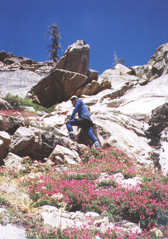
We had scouted the beginning of our route the night before, an easy trail up to Windy Gap. While returning from our reconnaissance, we came upon a pack of coyotes fiercely disputing dominance or territory. Now, in the cool light of dawn, the coyotes were sleeping off their battle, and we were looking over the gap at our destination. Still on trail, we dropped past Twin Lakes and overflowing Frog Lake. Just before reaching Maggie Lakes, we left the trail and headed west for the peak. We avoided most of the manzanita thicket that plagues parties that climb North Maggie Mountain from the Tule River. Still, we managed to lose our footing a couple of times on the smooth barked shrub. Tony gashed his shin and I slipped and punctured my water bottle. With my reading of the map reinforced by my brand new GPS receiver's directional clue, finding the 10235 foot summit was an easy matter. We were the first group to sign the summit register since the 20th century. There was a stunning view all the way to the still snowy Kaweah Range.
As we rested and ate lunch on the summit, we talked about the pioneers of the Sierra Nevada. Kirsten asked what was Kit Carson's full first name, then answered her own question: Kit is short for Katherine. Kirsten finally revealed the long hidden historical truth that Kit Carson was a woman. You heard it here first.
Our descent was not as charmed as our climb. We headed east, perpendicular to the Maggie Lakes trail. All we needed to do was to cross the trail at 9000 feet, take it back to Windy Gap, and then to our camp. Somehow, we managed to walk completely past the faint path without noticing it. We came upon a sturdy, well maintained trail at 8800 feet, but it headed down into Peck Canyon, not up to Windy Gap. Stephane wished that the trail concierge would come along just then, but that only happens in my dreams. I snapped a GPS waypoint. This unmistakable trail was absent on Stephane's current map, but present on my old 1955 era quadrangle. In spite of the fact that the USGS decided to omit mention of this trail, it was better and easier to find than the trail to Maggie Lakes. After a little scouting and a little consultation, we decided to follow the trail down into the canyon, then continue up the other side back up to Twin Lakes. This plan actually worked, though not before taking us through an inholding where the hostile rancher had posted alarming notices about using trespassers' horses as bear bait.
At Twin Lakes, we were back on route, and we should have made a quick return to our camp above Summit Lake. Yet somehow the flimsy trail eluded us a second time, and we ended up scrambling over a talus field to the pass just west of Windy Gap. I found the direction to my waypoint #30, which I remembered was at our camp. Too bad I remembered wrong! Old #30 was the spot where we ate lunch the day before, about 1/4 mile before Summit Lake. Although the etrek GPS allows the user to edit the name of a waypoint, I had been too lazy to use the editing feature, and instead had relied on the uninformative default name. There's a mistake I won't make again! When we saw the lake, we realized the error. It wasn't so bad going to the lake; we needed to stop for water anyway. Down at the lake, we found Damon Vincent and Corinne Hughes. We had planned to meet them mid-trip, so there was a second reason why my route finding accident was a fortunate one.
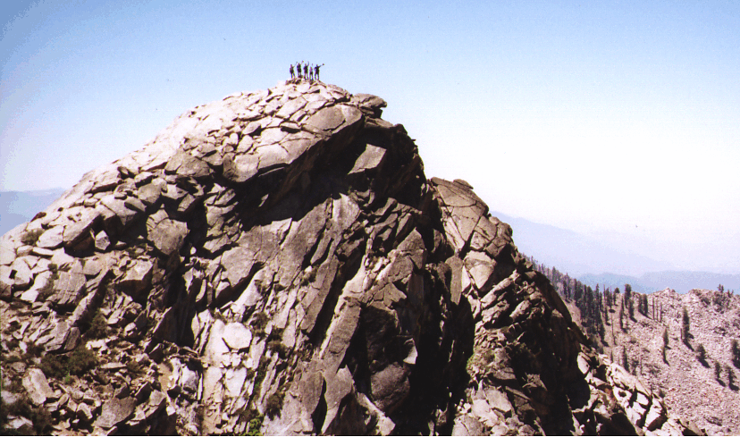
Sunday, our party, now seven people, packed up early and headed down the Tule River trail to the lower of two stream crossings. We stashed our backpacks in the woods and set out for Moses Mountain. In the steep forest, we found a bear's den, but the tenant was out foraging. On this mountain there was no avoiding wading eyeball deep through a furlong of brutal manzanita. We bypassed much of the brush by crossing it on the diagonal and clinging to the wall of the chute, but some whacking was just plain necessary. As we emerged from the flora onto a ridge, Tony decided to wait behind; he was bushed. After 700 feet of mixed class 2 and 3, we stood on the rugged rocky top, and gazed down at Porterville and Visalia. The final part of the climb was truly spectacular! The register revealed that we were again the first ascenders of 2001. We took some hokey posed photos, then descended to rejoin Tony and to reclaim our packs.
Back at the Tule River, we were surprised to encounter a group of our friends, led by Bob Suzuki, and including Joan Marshall, Ted Raczek, Joe Budman, and five others. Bob's party had set out to climb Rockhouse Dome that day, but found the charred Domelands Wilderness still closed to hikers since the huge blaze last August. They adjusted their plans and made a day hike up the brushy side of North Maggie from Mountain Home. We hiked all together through the giant sequoias for a distance, but split because Bob's group had started from Shake Camp instead of from closer-by Hidden Falls.
Then back at the road, we bathed in the river, and celebrated the end of a long weekend of exploration in a little visited corner of the western Sierra Nevada.
Hoping to beat the heat, I left camp near Summit Lake at 6am, soon saw snowshoe tracks in the mud and had to climb across 5' high snow mounds in Cyclone Meadow (which always gets more snow than elsewhere!). This area looks like Bubbs Creek except the creek is tiny. All downhill to the junction with the Windy Gap trail, where there are 3 streams instead of the one shown on the map. Once down this hill, I guess I was technically on the Hockett Plateau. All I know is that I walked about 25 miles that day, and only put in 2000' of gain (800 of it within an hour of camp on the way back).
From here to Atwell Mill (near Mineral King) the trail seems to be marked with red-on-white metal bits nailed to trees, 15' high. Coming over Windy Gap to Atwell Mill would be good winter ski route? This area isn't very map-friendly: the trail junction at Hunter Creek has signs for Blossom Lakes 4.2, Wet Mdw 4.5, Windy Gap 2.1, but nothing about the direction I'm actually traveling. Metal markers are now only 10' up - less snow here?
By luck I noticed use trails heading toward a meadow and went crashing over to find the Rock Camp sites, complete with bear boxes I thought were near Hunter Creek based on the Ranger's writeup. These campsites are quite nice, but only findable by looking for glimpses of meadow to your left as you walk north and assuming there must be camping in the trees. Between the southern and northern bear boxes the trail goes over a log-and-plank footbridge, and 50 yards north of the northern camp is a huge boulder field (east of the trail) with no trees and 10' boulders stacked against each other.
Southfork Meadow had ducks swimming in the lazy stream! Here the trail breaks free of the trees for the first time as you travel north, less than 2 hours from camp at my solo pace. The formal horse camp is just south of trail junction west to Touhy Creek, but that trail is not on the 7.5' topo so don't use the trail junction for navigation!
At the west end of Southfork Meadow you must cross to the southwest side of the stream to get to a large campsite with a small bear box. Hard to see through trees and across stream, but there is a horse-friendly ford and some downed trees I crossed near the outlet of the meadow. A use trail led to rocks one might cross on, but they were under water at this time of year.
It was a long and boring walk past Sand Meadow to the ranger station at Hockett Meadow. The buildings were boarded up, perhaps since the horse people hadn't started coming yet and hikers don't need rangers? This was the most mosquito free place I'd been since Southfork (because wind was blowing them to the far side of the meadow) so I had lunch here.
The backpacker's campsite is poorly defined, may be any of several sites along trail marked to Evelyn Lake, or may be right on meadow next to ranger station. The sign saying it's 0.1 miles "that way" may refer to the double steel pit toilets with privacy walls, but there's no sign other than "toilet" to indicate you've arrived! While I never found the cable said to be "100 yards north of the backpacker campsite", there IS a bear box about a third of the way to the ranger station from the log-and-plank footbridge where trail from the south enters Hockett Meadow. The box is just north of the trail in a well used campsite, along the stream which drains the meadow, very visible from trail.
East of Hockett ranger station there is a large metal box, not a food locker! Fading paint says "explosives" and it's padlocked. I kept going, cutting across the meadow and kicking up a swarm of mosquitoes that sounded like mad hornets! I dove into my goretex jacket and pants, but had trouble breathing because the damn things were thick as gnats and hard not to breathe in. The Horse Stockade bear box at Hockett Meadow is 1/4 mi across the meadow from the ranger station. You can find it by looking for the largest boulder just outside the tree line that defines the meadow. Closer up, the bear box is just behind an orange snow depth marker nailed to a tree and facing the meadow. Rather than risk being carried aloft by the humming hordes of hungry of mosquitoes, I crossed Hockett Meadow almost at a dead run by jumping braided streams. Some of the banks were undercut and some of the streams were amazingly deep, caution is advised after dark! Depending on which way the wind is blowing, pick the upwind bear box to minimize your loss of blood. (I'd ignore the fact that the stockade box is probably for horse packers only, and I'd definitely either carry a bear cannister or use these boxes: I saw fresh bear tracks and scat several times.)
The Horse Creek food storage cable DOES exist, in contrast to the one supposedly at Hockett Meadow, and there should be more like it in the backcountry. The cable is attached permanently to one tree, runs over to a pulley on a second tree, and then down to a latch which allows raising the food without a counterbalance. To get your food, the bear would have to break a quarter-inch cable, walk a tightrope, or pull a beefy-looking eye bolt out of the tree. Just north of Horse Creek, there are several campsites on the east side of the trail. The cable is in the LOWER campsite. Look for a 2' metal bar hanging from middle of the cable and/or a wooden sign announcing the cable. The sign had been hidden, for reasons I can not fathom, but I put it back in place. The cable is about 75' from trail, 60' elevation above the stream crossing.
Horse Heaven after Mosquito Hell between Hockett and Southfork. No bugs here at all, gorgeous warm temps, took a dip in Horse Creek at noon, fell asleep drying off, spent 1.5 hr on a large flat rock in middle of stream. The sound of the creek, the warm gentle breeze, the total lack of bugs and people, all made me want to stay the rest of the day... but I had to re-enter hell to get back to camp.
I tried the northern trail to Hockett Lakes, crossing the upper end of Sandy Meadow, hoping to find Upper Camp. Didn't, but it might be there and just not visible from the trail. Turned around, went cross country down Sandy Meadow proper (instead of returning to the trail) hoping to vector in on the bear box I'd missed when following the trail to the Touhy River before. I returned to the morning's Mosquito Hell by a new route, walked back and forth between potential campsites, found lots of fire rings and even more GREAT places to camp, but no bear box. I took a picture of the absolute swamp that makes this place beautiful to look at but also a place you must donate blood just to walk through.
12 hour day, got back to camp just before 6pm with no one else around! Ten minutes later my radio crackled to life as Aaron and his group hit Windy Gap and he checked in as arranged. I was pleased to find that my Audiovox radio (much like the Motorola Talkabout but lighter and smaller and cheaper) would punch through over a mile of trees, letting me know the group was safe and on the way to camp over an hour before they arrived.