The Bishop Pass trail runs roughly north-south through Bishop Creek Valley, and it's flanked on the West by Hurd Peak (12,219) and Mt. Goode (13,085), and on the east by Cloudripper (13,525) and Picture Puzzle Peak (13,280). On the weekend of June 16-17, nine of us set out to climb some of these peaks. The group included leader Bob Suzuki, Pat Callery, Jesse Hull, Arun Mahajan, Mike McDermitt, Ric Rattray, Sue Gygax and Wayne Martin from Bishop, and your scribe Jim Ramaker.
After a restful night at Deadman Summit, we met at South Lake at 7:30 on Saturday morning for the usual introductions and gear sorting. Departing at 8, we arrived at the far end of Long Lake (10,800) at 9:30 and set up camp. That was it -- 1.5 hours, our entire hike in!!! After a break, we hiked up the trail to the far end of Saddlerock Lake and then turned west toward Mt. Goode. The only mistake here was taking too direct a route, too close to the east ridge of Goode, which took us up sandy scree and steep brushy ledges. Circling around to the left onto the gentler southeast face would've made for easier climbing. Higher up we crossed talus fields and a couple of softening snowfields -- ice axes were helpful though not absolutely essential.
We topped out at 12:30 p.m., and after a nice rest, Bob proposed that we hike back to camp and then climb Hurd Peak. Most of us were already tired from our first day at altitude and preferred to remain horizontal for awhile. We pooh-poohed Bob's plan and started using various delaying tactics, such as taking photos and fiddling with gear, so that the Hurd Peak idea would have to be discarded. We also looked hopefully at some billowing clouds south of the Sierra crest, suggesting to Bob that even if we were to attempt Hurd, the peak would surely be raked by a vicious thunderstorm by the time we got there. But by 4 p.m. we were back at our camp, the clouds weren't doing anything, and the west slope of Hurd Peak was staring down at us from the other side of Long Lake.
"All right, who's going?" Bob asked. As usual on my first day in the mountains I felt weak and wanted only a nap, but for some reason I joined in along with Arun and Pat. My rationalizations were that there were a few bugs in camp and there wouldn't be any on the peak, and that it might be interesting to get so tired that my legs collapsed. The four of us trudged over to the base of the cliff and started up. "I feel like death," Bob mumbled by way of encouragement. We struggled uphill over some brushy ledges, negotiating a short vertical section by pulling on bushes. "Bob, why are we climbing this stupid peak?" we moaned, as Pat regained his sanity and headed back to camp. "It's not even on the list!" (meaning the sacred SPS list of 247 Sierra Peaks)
"Because," Bob explained, "Every time you hike up to Bishop Pass it hangs over you, and now you'll be able to say that you've climbed it."
As Arun and I contemplated this flawless logic, our second wind slowly kicked in, and we actually found ourselves making progress up the class 2-3 scree gully and getting in range of the summit ridge. I spotted a ramp off to the left that looked more solid than the gully and headed up it in a brilliant energy-saving move. In a few minutes I was on top of the narrow ridgetop with a 30' vertical dropoff between me and the summit. An old rappel sling circled a block at the lip of the dropoff -- I love finding rappel slings when I'm trying to downclimb unroped. I went back down the ramp for several hundred feet and circled around, finally joining Bob and Arun on the summit.
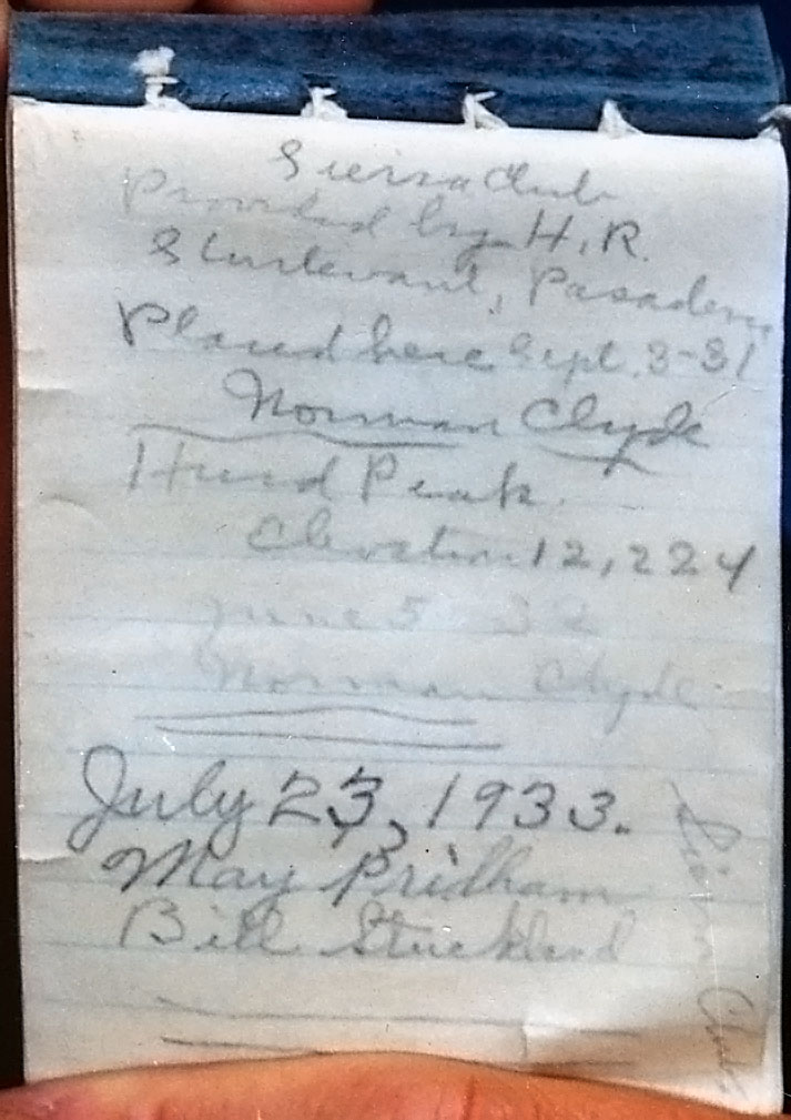
We couldn't find the summit register, so we checked a slightly lower summit to the north and then Bob traversed some class-4 to a third summit. Still no go. Bob seemed disappointed that there wasn't a fourth, fifth, and sixth summit tower for him to go and investigate. Back at the true summit, I finally found the register in a glass jar buried in the rocks, ending our torment. After a brief rest, we descended the gully just north of the one we'd climbed, which had nice scree for the descent and no vertical step at the bottom. We finally got back to camp at 8 p.m. Sleep was not long in coming that night.
Here's a picture by Steve Eckert, published here only after the old Hurd register vanished:
On Sunday morning we were up before 5 a.m. to have a go at Cloudripper (except for Arun, who set off to solo Agassiz). From our valley, Cloudripper appears as a long, almost level ridge with a consistently steep west face. We spotted two scree gullies that we thought might go -- an S-shaped gully to the left (north) of the summit, and another gully to the right of it. The headwalls of both looked steep, but we figured that our straight-on view was exaggerating the steepness. The S-shaped gully was lower angled at the bottom, but it had a hidden section we weren't sure about and was also further from our camp. The right-hand gully offered a more direct route, and was shorter than the S-shaped gully because it started from atop the low, rounded ridge between Ruwau Lake and the Chocolate Lakes that buts against the face of Cloudripper at right angles. After lengthy debate, we decided to try the right-hand gully, except for Sue and Wayne, who preferred the S-shaped gully.
We hiked cross-country and then via trail up past Ruwau Lake, then headed eastward up the rounded ridge to the base of our gully. From here the gully looked more reasonable -- just your basic Sierra Scree fest. We headed up, climbing slabs and blocks on the left when possible to avoid the loose rubble. There were a couple of thin snowfields in the gully, but we avoided them because we didn't have crampons. About 500 feet from the top of the gully, a more solid looking, class-3 gully branched off to the left, and Bob, Pat, Ric, and Jesse went that way, while Mike and I plodded onward.
The gully headwall that we had feared might be class-4 was actually class-2 scree, and Mike and I soon reached the ridgetop. Terrain on the other (east) side was moderately steep, with ribs of shattered rock plunging down to scree hundreds of feet below, and the summit tower plainly visible 500' feet to our left along the ridge. Luckily a beautiful system of sandy scree ledges led leftward, averaging about 30' below the ridgecrest, and the ledges took us all the way to the base of the easy class-3 summit tower.
From there, we saw Bob and crew several hundred feet back along the ridge. They'd encountered a couple of class-4 sections on the way up to the ridgetop, and were trying to climb a different summit tower, much steeper and harder than ours. A glance at the map confirmed that we were at the marked summit, so we yelled to them to come join us, then scrambled to the top. There we found the summit register and confirmed by sighting against the horizon that our (north) summit tower was a few feet higher than theirs. After 20 minutes or so they joined us, and then Sue and Wayne also appeared, having made excellent time in the S-shaped gully. By 10 a.m. all eight of us were relaxing in the warm sun, taking photos, eating, and reading the register. Because Cloudripper sticks out two miles from the Sierra Crest, it offers wonderful views of the major Palisade peaks and the Palisade Glacier. Views to the north were also excellent, with Goddard, Humphreys, the Abbot group, and dozens of lesser peaks in view. We scanned Agassiz for Arun but could see no movement on its slopes.
Sue and Wayne decided to descend their S-shaped gully, while the rest of us reversed the ledge system that Mike and I had used and then descended the scree gully. As is usually the case, especially when a party is tired, we got spread out vertically and dropped some scree bombs on one another, but luckily took no hits. Back in camp around 1 p.m., it was uncomfortably warm for almost 11,000'. We packed up and waited about 30 minutes for Sue, Wayne, and Arun to appear, then decided it would be okay to leave because they were all experienced and neither of their routes offered any real danger. In the event, they got to camp shortly after we left and got to the trailhead not long after we did at 3 p.m. All in all, a great trip -- three summits and home to the Bay Area at the uncharacteristically early hour of 11 p.m.
Arun Mahajan adds:
> On Sunday morning we were up before 5 a.m. to have a go at Cloudripper > (except for Arun, who set off to solo Agassiz).
A short note on this side trip to Mt Agassiz (13893 ft).
After bidding farewell to the PCS team as they went for Cloudripper, I set off at 6.30am from Long Lake on the trail towards Bishop Pass and topped it at 8 am. Agassiz is not much harder than class-2 from here and is a talus fest and resembles climbing Mt Dana for instance. There is some snow on the peak and if you would like to avoid the talus and are starting the climb at this morning hour, get your axe and crampons, the snow is sufficiently hard.
Starting at 8.15, I was at the summit at 11, my lame excuse for this slow time is still going to be that I was tired from the day before. The view from the top is astounding. Mt. Sill and North Palisade and the Palisade Glacier dominate the view.
Back at camp by 2.30 only to find that the rest of the PCS crew had already returned from their Cloudripper trip and had quietly folded their tents and stolen away. Wayne and Sue returned from Cloudripper at about the same time and we had a pleasant hike out to get back to the South Lake parking lot in just over an hour.
Many thanks to the leaders, Bob Suzuki and Pat Callery for their leading and for accomodating my request for a last moment sign-up and for letting me splinter off and do Agassiz.