The difficulties started at Willow Lake, in trying to find the use trail west of the lake. There are two streams which have to be crossed before picking up the main one feeding Willow Lake, and we messed around for a while getting across them. In the process we stumbled across the use trail which runs along the south side of the main creek. This trail is tricky to follow at times, but offers a pleasant way up the creek. That is, until we got to the boggy patch where the first major side creek comes in from the south. We didn't know it, but the trail crosses the main creek around here. There's a convenient log there if you look for it. This takes you on to boulders on the other side, instead of the easier walking to that point.
We continued on the south side, skirting right around the bog, which was replete with mosquitoes. This side is much more bushy than the north side, so the going is tougher. However, it made it easier to find the second major side creek, which is the one leading to Elinore Lake. If you're going on the north side, you really have to look out for the gulley to the south. We noticed it was just before the main creek tumbled down a particularly steep section, which is a good landmark.
We climbed up the east side of the gulley on boulders and arrived at Elinore Lake just in time for a few sprinkles of rain. This was not normal thunderstorm activity - tropical moisture was in the air and the clouds had been increasing all day. Luckily we never got more than the sprinkles, for which I was grateful as I had only my bivvy sack with me.
That evening we attempted to reconcile what we were looking at on the ridge leading up to Scimitar Pass, and the description in Secor saying to "head for the flat spot on the ridge". What flat spot? We saw several, all accessible only by climbing what looked like cliff faces. Well, oftentimes perfectly climbable faces look impossible from a distance, so we'd wait and see. We went to bed at the deliciously early hour of 8 pm - the clouds prevented any alpenglow so it wasn't worth waiting.
Next morning we headed out over the boulder fields. There was so much of this that John spontaneously burst into song "Boulder fields forever" to the tune of Strawberry Fields. Very appropriate: such was the boulder hoppping that I ended up with blisters where I'd never had them before, in old boots that had never given me troubles before. When we crested over the first hump we could see the snowfield and glacier that had been hidden at camp, barring our way to the ridge. Our route was going to be determined by what we could do with no ice axe or crampons, rather than what looked the best rock.
We picked what looked to have the shallowest angle at the top, kicking steps as the slope increased, but it soon became apparent we couldn't keep going as the snow was getting harder and the final bit was still in shadow, ensuring a hard, slick surface. We downclimbed a little, then traversed to a point where the snow had been in the sun longer and ascended again. This took us to a bergshrund which had to be negotiated, and the final exit from the snow was pretty steep (around 40 degrees or so). We didn't want to go back down that way. However, we weren't the first people to be there, as we saw a rappel sling attached to a rock right where we left the snow.
Leaving the snow was the beginning of the next challenge. Every rock we put our hand on came loose. This was some of the worst loose, unreliable rock that I've ever had the misfortune to climb on. Some class 5 moves were necessary on our way up the face to the ridge top, totally unprotected of course as there was nothing to get any pro into. No matter how careful we were, we couldn't help dislodging stuff as we climbed. John and Chris had helmets to protect them, and I had my Australian Akubra hat, which is (arguably) almost as good. It certainly warded off a few showers of stones. Paul Hogan would have been proud of me!
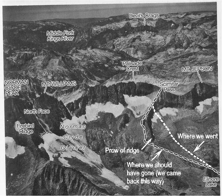
As I was about to pull myself over the final lip, John said "Peter, don't come up because you won't like what you see". He was referring to the gently sloping boulder field covered in snow. This was the route we SHOULD have taken. "I know the way we're going back", he said.
From there it was easy going to the pass - yes, it really is class 2. From there along the Sierra crest definitely isn't, though. It starts easily enough on the west (right) side, but soon the boulder scrambling stops when the boulders give way to vertical rock faces and one is forced on to the crest top. From that point all the way to the descent to the notch between this crest and Palisade Crest is very exposed class 3. We could have a discussion here about what constitutes class 3 and what class 4. I would call this a class 4 crest because although the moves aren't particularly difficult, in many places a slip or mistake would send you to certain death. Looking down the vertical north face of the crest to the snow below is awesome!
By the time we got to the point to descend to the notch it was lunchtime and we re-evaluated the situation. I was feeling low on energy, possibly due to the fact that this was my first time at altitude for 10 months. We still had a fairly significant downclimb to make, followed by the 160' inclined slab that we'd have to rope up for. It's one thing to make the summit, but one has to return, and I didn't want to compromise safety on the way back along the crest top due to tiredness. A mid-afternoon summitting did not feel very attractive so we stopped there and ate a leisurely lunch. This gave John plenty of time for his famous "power lounging" which he did so well he fell asleep. The weather was perfect, with none of the threatening clouds of the previous day.
As expected, the correct way back was a breeze. The snow was very deeply sun cupped so we had to be careful, but the slope was relatively gentle and posed no problems. Our route took us around the prow of the ridge, through what is effectively a gap, since the ridge continues on the other side of this gap for a way. I think a better description for the ascent from Elinore Lake is not to hear for a flat spot, but to head around the prow of the ridge, through the obvious gap there. The accompanying photo shows the details. This photo was copied from page 181 in R.J. Secor's book (with his approval) and it also appears on page 214 of the 2nd Edition.
There were no clouds to obscure the alpenglow this evening, but we went to bed early anyway. We'd all seen it before, and the particular mountains lit up weren't all that spectacular anyway. We preferred to go to sleep and dream about what it would have been like if we'd taken the correct route.
Our hike out the next morning took only 4 hours, since we knew where we were going this time. This put us in Bishop at a timely hour to eat lunch at Whiskey Creek - a restaurant that John and Chris convinced me to try. The service is fast and the portions enormous. It's more expensive than Sizzler but a darn sight higher quality. I waddled back to the car replete with fish and chips and beer. A great way to end our adventure.