18-19 Sep 1999, Needham Mtn (12,520'), private trip
Leader: Steve Eckert
Participants: Rebecca Eckert, Bill Isherwood, Tanya Knaus, Alex Sapozhnikov
![]()
Driving to the trailhead I knew we might be in trouble. The Mineral King road is always winding and narrow, but this time it had pine needles and evidence of temporary streams crossing it, indicating there had been a MAJOR rain/wind storm that afternoon. Not to be deterred, Rebecca and I pulled into the soggy campground under clearing skies and struggled to light a campfire on wet ashes... this was her first backpacking trip, and we were going to start it right (with s'mores and lawn chairs) even if it meant using our permit reservation to kindle the flames! A bushel of wood and a bag of marshmallows later, we turned in. No rain until just before dawn on Saturday, when lightning and a shower woke us up.
Everyone was at the appointed meeting place early, the ranger was friendly, and we were ready to walk when Larry Sokolsky and Denise Ellestad decided to back out. They had been chased down the same trail once before by a close lightning storm, and the early morning clouds had them running scared. (I hadn't seen any big storm forecast, the ranger said the worst was supposed to come through Saturday evening, and our departing members acknowledged that they might be making a mistake. They did!)
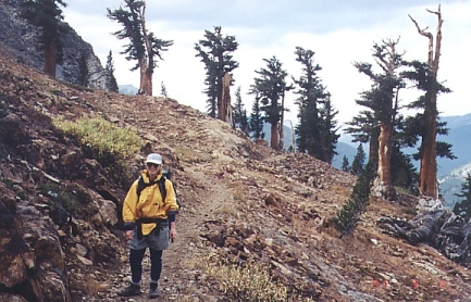
Choosing a one-mile-per-hour pace, we sauntered up the short trail to Monarch Lake (the signs say Sawtooth Pass) in about four hours. Once it threatened to rain, but rain jackets were mostly used as windbreakers. Neither Tanya nor Rebecca had climbed a Sierra peak before, so it was fun to enjoy the trail through their eyes as if I hadn't been up it half a dozen times before - see RebeccaOnMonarchTrail.jpg. We saw deer, grouse, squirrels, and marmots at close range (30' or less). Something about this area makes animals behave as if you're in a petting zoo. They don't run away! I never got Alex to pronounce his last name, but we talked about everything else along the way.
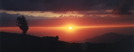
OK, so we're at camp and our food is in the bear boxes. Now what? It's early afternoon, I'd like to scout the passes above Upper Monarch Lake to see if we can bypass the sandy Sawtooth trail, but the clouds are heavy so we set up camp instead. Minutes after the tents are up the first shower hits and we dive inside for a nap. Sun, rain, sun, hail, all afternoon. We lunch on a rock overlooking the lake, but choose to sleep the afternoon away instead of getting wet and risking a lightning strike. The clouds broke just enough for a stunning sunset (MonarchLakeSunset.jpg) and we drifted to bed just after dark, ending the evening with a cake that Tanya BAKED IN CAMP. Those camp stove ovens actually work!
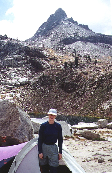
Sunday morning most of us left camp at first light (a cohesive and eager group that was a joy to climb with) while Rebecca slept in and read a book. (On her first backpack, it's enough to be camped at 10,400' and having a great time in a completely new environment, which you can visit vicariously by viewing MineralPeakFromMonarchLake.jpg) There are several use trails to Upper Monarch, from where we turned south to the lower saddle via an easy talus chute that Bill called a "shear zone". There was minor confusion over which lake was in view, but noting a lack of islands and checking with a compass verified that it was Crystal Lake. Next time I'm in the area I'll take the trail to Crystal instead of Monarch. It's a beautiful valley, not littered with trash like the Monarch area.
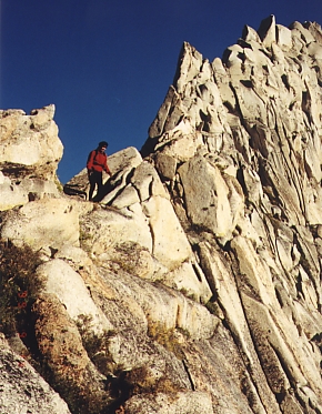
From the saddle between Upper Monarch and Crystal, we headed east on the ridge, then sidehilled a bit south to the saddle between Crystal and Amphitheater Lake. This saddle is high class 2 on the west side and VERY easy class 3 on the east side. (See CrystalAmphitheaterPassEast.jpg for a picture that makes it look a bit worse than it really was - remember that Tanya, in the picture, had never done class 3 before!) We zigzagged a bit, then dropped nearly to the lakeshore. I think it would be better to stay high and get on the ridge, to avoid some steep friction slabs, but either way you can almost do this without your hands. Going around Amphitheater's outlet is the best way to see the sights of the SE drainage, and the slab/tundra walking to the base of Needham is some of the finest the Sierra has to offer. This approach avoids the nasty sandy boulder slog from Sawtooth, and is highly recommended as more aesthetic (and far less up-and-down gain than the south Sawtooth ridge route recommended by Secor).
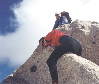
Bill turned his sights on Sawtooth, wanting to shorten the day, while we picked our way through a short boulder field, and found a use trail that traverses the sand to the first saddle west of Needham. From there it's a grunt to the peak, but not terribly hard going. The summit block is not really class 2, and neither Tanya nor Alex wanted to step up the last 4' onto a narrow block (only room for 2). Everyone touched the top, and I was pleased that inexperienced climbers kept their cool and took their time with the few class 3 moves required to get to the summit register. Have a look at NeedhamSummitBlock.jpg for a fun climbing technique that reminded me of Mark Adrian on Center Peak last year.
We savored the top for an hour, and while going down discovered that Alex had "hit the wall" with altitude problems. Slowly, with great determination, we made our way around the other side of Amphitheater to check out the saddle between Upper Monarch and Amphitheater. I got within 10' of the saddle, finding moderate class 3 ledges that lead almost to the south end of the low spot, but 5' of underclings with brush in them would have been required to top out. Bummer. Dropping down 150' we traversed back to our original saddle, staying high to go above the slabs that cliff into the lake. This direction is moderate class 3, but harder than going around the outlet side of the lake. See SawtoothAmphitheaterFromNeedham.pdf for a panorama with our routes traced over it.
Retracing our steps to camp, we arrived about 3:30pm without a single drop of rain. The pictures show patchy cloud cover, but the storm had roared through camp Saturday night (wind but no lightning) and left us alone. Poor Larry and Denise were on our minds as we packed out and the sun sank while cotton candy clouds settled over all the area peaks. Fall weather is never predictable, but if you're willing to risk the occasional shower you are rewarded with dramatic cloud accents. The drive out included sunset in steep canyons, and we finished the trip with a good dinner at the Noisy Water Cafe in Three Rivers.
I'm glad everyone had a good time, but I'm especially happy/proud that my wife had no problems and enjoyed her first trip. I now have only one more peak to finish the SPS Peaks List, and she'll be on that trip also. Stay tuned, and look for the Kern Peak list finish report in an upcoming SPS Echo. (If you don't get the Echo, contact SSullivan0@aol.com for an application.)