The weekend of the 15th was President's day weekend and a friend and I had planned on having our annual Death Valley trip this weekend. With a week to go he found out he had to work, leaving me all by myself with three free days, which I decided could be welt spent making an attempt at lonely miss Olancha. Once again I changed my mind right before I left, this time choosing to go to Death Valley anyway. After getting some information on possibilities through e-mail I decided on 8,953 foot Tin mountain, the northernmost peak of the Pannamint range.
I made a not-so-quick phone call to Alan at the Death Valley NP visitors center to get information on camping regulations and road conditions, packed and made it out the door at 8:00pm. On schedule for a change, I made Bakersfield by 9:30 and Mojave at 10:30, stopping for what could have been my last gas of the night. I then set off for Olancha, stopping at the 24-hour BP station on Gill Sta Coso (what ever that means...) Road. The sign at the junction of 395 and 190 in Olancha read "Death Valley 101 Miles" and it was already midnight. By the time I made it accross Owens Lake there were no longer any radio stations so I settled in for a long night of road noise. Soon after I passed over the unsigned crest of the Inyo Range I saw a sign announcing that I was now in Death Valley National Park. I was absolutely terrified. The the park boundary was at least 45 minutes away, if not more, and terrifying thoughts of alien abductions filled my head. The terror subsided as quickly as it came when I remembered that the park boudary was also extended westward by the Desert Protection Act. The trip down to the bottom of the Pannamint Valley was quite possibly the worst I've ever experienced, much worse at 1am than 168 over the Inyos was at 3am. Soon I whizzed past Stove Pipe Wells and then headed north to Ubehebe along a road with out a single reflector for over 40 miles. My brain was completely warped from the concentration of picking out the faded asphalt from the white sand of the valley floor when I arrived at the crater. This is when the fun began. At 3am I pulled off the Ubehebe loop onto what could easily win the "worst washboard" award, Racetrack road. I drove my 2 miles and then pulled off for my 3 hours of most uncomfortable sleep in the front seat of the car.
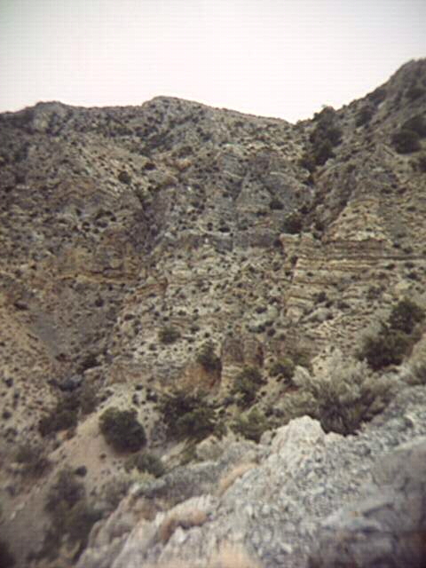
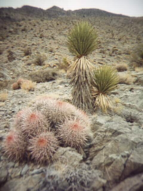
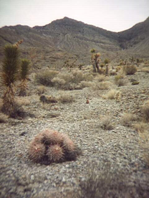
At first light I awakened cursing the sun, then slept for another hour. When my legs were completely numb from the contortionistic postition they were in I finally arose, only to find that I had another 8 miles to drive along the washboard, which only got worse the further I drove. Of course, nothing I do can go off without a hitch, and this time I was mapless. If all else failed, I could at least go on the Scotty's Castle Tour. Having no map, I had know way of knowing where the summit of the peak was and tried guessing where the highest point on the ridge was. This was task wasn't made any easier by the fact that Tin Mountain stands near the intersection of the Pannamints and the Cottonwoods and that the high spots that I was seeing could belong to cottonwood peaks instead. By 8:30am I had decided on a mountain to climb, whether or not it was Tin Mountain (as it turns out it wasn't) and started east, from a bend in the road north of peak 5,022, accross the most massive alluvial fan I had ever seen. The plants were amazing. The fan was covered with Joshua trees which although short by Mojave standards seemed to be thriving. Most striking though were the small barrell cacti with bright pink needles. It almost looked like a scene from some low budget science fiction movie with little no armed fuzzy headed men and little pink animals running around their feet. I guessed the fan would take me 15 minutes to cross. Over a thousand feet and half an hour later I was standing at the base of the range, the side of which was so steep that I could no longer see the peaks above. From my vantage point I could see part of my intended route, which followed a 50+ degree ridge between two drainages, each with massive crackless vertical solid rock walls. Clearly if my ridge didn't make the crest of the range I would've had to return to the car, for there would be no way to traverse accross to another ridge.
I made for the top of a small reddish drainage filled with terrible scree, which came off of a small flat 400 feet above the edge of the alluvial fan. From here the ridge headed northeast for a while until it reached another flat and turned back east. While on this second flat I paused for a snack and some much needed water and then planned my next leg, which would lead me up the crest of the ridge to the flat west of peak 8,200+. Accross the tops of the Last Chance Range I could see a steep range with a serious coat of snow that stood out from its dark composition. To steep to be the Sierras I decided they were they Inyos. There was no point in trying to identify any of the peaks because I didn't know any, so I pressed on. While on the flat I picked up what looked like a use trail and followed it as it snaked up the ridge for a while, but soon the hiking turned to climbing about 200 feet below the flat. As the ridge stepened the rock got worse, quickly turning into nasty scree covered class 3 rock. The rock was fractured in such a way that it formed hundreds of little knifes, making good holds hard to find. Finally I climbed through a keyhole to find myself on the flat. Looming dead ahead was the rocky summit of peak 8,200, still over a thousand feet up, but close enough to see that the top was sheer rock and the sides were even worse.
After deciding against crossing the canyon and ascend the slope to the north which ended in peak 8,600+, I headed north again to contour around and see if there was anything easier on the side of the ridge I was on. Once again, I found a use trail aimed right where I wanted to go so I followed it. After meandering around the edge of the canyon and then switchbacking up the side of the peak on loose scree slopes, the use trail, hard to follow at times, completely disappered, leaving me stranded atop a giant outcrop jutting out above the canyon far below. Here, wallowing in my failed attempt, I had lunch among the birds, which taunted me, crying out "I can make it and you can't!"
I paused before heading back to the car to look west accross the valley at a giant dark pyramid rising from behind what I thought was Dry Mountain. From my vantage point it was clear that what I was now seeing was in fact the peak of Dry Mountain (8,674) and what I had seen from below was one of the lesser peaks (8,432) on the edge of the ridge top plateau so common of the desert ranges. After taking a compass shot and finding that I was south of Dry Mountain, I felt reassured that I was infact on Tin Mountain and for a short moment my spirits were lifted enough that I decided to climb on. With no trail to follow I went the only way possible, down into a scree chute comming from the top of peak 8,200. A few quick class three rib traverses later, I found my self in a wide talus filled depression. The first step I took onto the talus sent a three foot boulder crashing 400 feet into the bottom of the canyon. I was foiled once again. As I was turning back I noticed that the headwall seemed to have a ledge along the bottom where it met the talus. I aimed for the ledge, knocking off countless boulders but managing to hang on. Finally I made the ledge and walked near it, finding that the talus there was quite stable. Here, again, I was faced with heading down to the canyon or climbing 30 feet up a rotten scree chute, and again I chose up over down. At the head of the chute I climbed east over a large outcrop and stood gloriously overlooking the giant canyon at what I thought was Tin Mountain, this time though with a clear route in sight.
Now invigorated I paused to duck the proper chute and then pressed on, ducking my route as I went. I took a moment to climb the easy class 2 summit of peak 8,200+ and then strolled quickly along the flat ridge separating the two menacing canyons and then up the gentle south facing slope of what I thought was Tin Mountain. Triumphantly, at 12:00pm, after over 4000 and only 3 and half hours of climbing, I found my self standing atop....peak 8760+....staring at the forested summit of Tin Mountain half a mile to the northeast. To the north was peak 8,810, which was what I had guessed was my destination.
Without hesitation I practically ran up the remaining 200 feet, finally petering out at tree line. The wind quickly picked up and the pinyon weeds (for those that do not share my view of pinyon trees, take a look at the 15' minute toppo from the 1950s and you will see no trees indicated at all on the entire map and now they occupy almost all of the north facing slopes) were whipping around furiously. One tree on top, which was wearing a ball cap, was actually blowing so hard that it appeared to be walking up and down the ridge. I quickly realized that after all of my effort I was not alone. As I ground out the last few feet I took notice of a party of at least 10 people, all huddled around the summit register. After all of my effort I didn't even get to do my normal summit routine (yelling, screaming, eating Spagetti-Os, etc).
After I consumed a whole quart of water in a matter of seconds I turned around and saw one of the most breath taking views I had ever seen. Sprawled out before me were the great heights of the Sierras and the Inyos, from Bear Mountain (east of kennedy meadows) to Mt. Tom and White Mountain in the north. To the northeast were so many ranges I couldn't count them if I tried, and to the south east were the Grapevines and far off snow capped Mt. Charleston. Far south was the highest peak of the Pannamints, snow clad Telescope Peak. I've seen my share of views, but this one topped most of them, if not them all.
The party was from the desert survival league or something along those lines. They asked how I came up, where I was from and all the normal questions. After a few minutes of conversation I looked at my watch and found it to not even be 12:30 yet. Although I found them quite pleasureable, and picked their brains about which peak was which, I really would have preferred to have been lucky enough to share that view with only myself. I shot a whole roll of film and, took some panoramics, and then relaxed. At one I headed north to summit peak 8810, which took all of 10 minutes and then headed back the way I came.
Once again the class 3 sections threatend to ruin my good time but I carefully passed them without incident, takiing more time to go down than up, and then continued down hill. After a few wrong turns I located a use trail which took me back to the highest flat on the ridge, and then continued on around the south side of the ridge, bypassing the class 3 rocks on the ridge crest. Altough very faint it was clear where the path went and in no time at all I was at the next lower flat. I would have saved at least half an hour by taking the use path, but thats the 20/20 vision of hindsight. My knees ached terribly as I navigated the steeper part of the ridge, once again loosing the path. After reaching the lowest flat I decided that it would be easier on my knees to follow the ridge to its terminus and then climb down to the fan instead of taking that scree chute again. At the end of the ridge, where it met up with the one of those nasty canyons, was a big sandy chute complete with use trail at the bottom. I was back at the car before 5. On this day I was not only rewarded with a most remarkable climb of a wonderful mountain, but I was given an opportunity to watch the most beautiful sunset I'd ever seen. I then drove home watching the moon light dance with the clouds.