As with everything else, there is a right way and a wrong way to climb a mountain, as I learned Saturday, January 11th on my solo ascent of the southernmost Sawtooth Peak (7970).
As goes the story of my life, I left two hours late from home, near Reedley. What is normally a 90 minute drive down J19 and HWY 99 to Bakersfield turned out to be a 3+ hour trip through tule fog so thick that I couldn't even see the fog visibility test signs. Finally the fog disippated, but only after I entered the Kern Canyon, where I couldn't make up any lost time. As usual there was a member of our highly esteemed state law enforcement agency waiting at the begining of the four lanes, and again I couldn't make up any lost time. It was now 10:15 and I was finally making up my lost time flying through settlements with names like Weldon and Onyx.
It turned out I made up a little too much time, as I found my self climbing to Walker Pass, leaving Canebrake road, my intended route, far behind. 5 minutes later I veered right onto a dirt road, in the middle of possibly the biggest grove of Joshua trees in the Sierra, signed "Chimney Peak Fire Station". It was nearly 10:45 and still there was no sign of the PCT, where I was to begin the first leg of my trip. Once again I went whizzing past my destination. This time however, I didn't miss the sign, as there was none. My only clue that the trail was in the area was a pickup parked next to the brush.
Finally at 11:00, I began my hike to the Sierra crest along the PCT. The views along the trail were outstanding. Far below, one of Lamont Meadow's brushy fingers pointed out the way for me. The mixed oak/pinyon forest gradually gave way to pinyons with willows in the canyon bottoms.
As 11:30 came near the rumblings in my belly became more pronounced and I paused for a snack in the shade of some willows in the bottom of a small canyon. If only I could have seen through the willow trees......
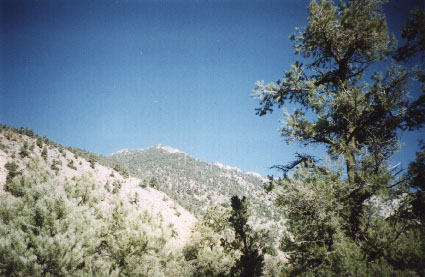
At 12:00 I was finally at the Sierra crest, overlooking steep sided Sand Canyon. Off in the distance was the town of Ridgecrest and the Coso, El Paso and Pannamint mountains. West were the summits of Lamont Point and the nipple shaped Pilot Knob, and far to the north was the rocky summit of my goal, Sawtooth Peak, only 1 mile and 2,000 feet to go. I paused to take on some water and plan my next leg.
The southwest ridge of Sawtooth Peak was very exposed at the 6,000 ft level but as the elevation increased, so did the brush. Soon the rocky summit block was completely obscured by the Pinyons and snow patches were becoming more frequent in the shady areas. As the Sierra crest rose to the peak it wandered aimlessly as did I, picking my way through the trees. Two thirds to the top the grade steepened and an army of false summits challenged me, one after another.
Finally, I was standing next to the summit block. From my viewpoint it was a 40 foot block of solid rock with a few class 5 cracks. This couldn't be the right peak I thought to myself, as 2:30 neared. I walked through the trees to the north side and found it to be much easier, but still nowhere was there any class 2 rock to be found. After giving up looking for the class 2 rocks I hoisted my pack up a couple of short class 3 moves and found my self standing atop Sawtooth Peak, the second highest point in the Owens Peak group. The view was absolutely amazing: far off Telescope Peak, the hulking mass of Owens Peak, the striking spires of Lamont Peak, the lonely summit of Olancha Peak, the snow covered heights of Mts. Whitney and Langley, and to the northwest Mineral King. Most striking were the snowless summits of the Kaweahs, with the Black Kaweah bare from top to bottom. I had lunch, took my photos and signed the book.
Up until this point I had been loosely following the outline given in the book "Exploring The Southern Sierra East Side" and had found it accurate enough. The trip as outlined in the book was a loop that descended the west face of the peak. Sounded good enough. Following the book (this is where the wrong way begins) once again I descended through the trees to the opening of a canyon with steep rock walls. As I followed the canyon the walls got steeper and it got much colder. There was a noticeable snowpack in the bottom and there was ice in places.
The trip down was actually quite fun, right up until I hit the 60 foot ice fall! It was now 3:30 and the sun would be down at four. With nowhere left to go I walked out onto a ledge, at the end of which I had two choices: climb up or climb down. I soon found myself in a class 4 chute tossing my pack down to lower ledges while stemming down between rocks. At the bottom of the chute was a frozen stream thickly lined with willows. After 10 minutes of picking my way through the tangle of branches I found myself back on the PCT, where I had that snack seemingly so long ago. I will never understand why the authors of the book listed the peak as class 2. Even more mind boggling is why anyone would choose to go down that canyon! This was the first time I had ever taken longer to go down than I had to go up.
After a nice hike I was back at my car in only 20 minutes. After watching the last rays of light dancing behind the valley fog disappear I made the long winding trip back home.
Look north towards the summit [41 KB] of the southernmost Sawtooth Peak (7970) from the Sawtooth - Lamont saddle along the Sierra Crest.