18-20 Oct 97, bagging Vandever/Coyote/Angora/N. Maggie, mostly a solo trip. This report is too long and too detailed, but few people go to this area and I've had several requests for information. If you don't like documentaries, stop reading here!
Grunting up from Mineral King to Farewell Gap with Schuman's dayhike group I had to question my decision to carry a full pack with four days solo supplies. It was much colder than overnight at Atwell Mill, perhaps because a "controlled" burn had warmed the valley? Anyway, we took only 3 hours to reach the Gap, and happily ditched gear for a quick run up Vandever (OK, not so quick, over 90 minutes up).
Alone, I headed south from Farewell after saying farewell to my friends. I looked down this trail once before, when I was much younger and much less prepared. The memories of a sudden storm flooded over me: failing to reach Vandever, returning to the Gap, sitting down in hypothermic confusion over which way to turn, dimly understanding that my partner was saving my life by forcing me to get up, and stumbling back to the car at 11pm. Not this time - more gear and more experience!
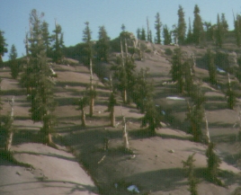
The trail south of Farewell is grown over by weeds. It's a nice place, but fairly dry. Some streams on the map (like south Rifle) are not actually there. I made camp by the last trickle before the trail climbs to Coyote Pass, forced to camp on the trail itself due to the impenetrable brush cover in the area. The signs are wacko here, as around Vidette Meadow, with widely varying distances to trailheads from sign to sign. I think the first day was around 14 miles and 4700', but who really knows?
The moon lit my breakfast and packing, and I was walking at first light. October daylight can't be wasted, especially when you are in unfamiliar terrain. There was a trickle of water near Coyote Pass, but I think this was fall snow melt-off. This is a dangerously dry place if you don't plan ahead! The trail appears to have been re-routed, climbing hundreds of feet above the pass and then dropping in sandy soil. Junctions are impossible to find unless you get lucky and see a sign, but cross-country travel is easy here so just head for where the trail should go and you'll find it soon enough.
As I approached Coyote Peaks, the amount of fresh snow increased rapidly. I kept losing the trail, and I saw what looked like several feet of snow in the saddle, so I cut left around the western summit and hit the saddle between the Peaks (not the trail saddle). From there it's a quick no-pack scramble on fun boulders to the summit. Only one other person signed in this year, a ranger tired of hand-splitting roof shakes. Back to my pack, over the west summit, to the saddle where the topo shows a trail junction. I couldn't see any evidence of trails, but I spotted at least 5 signs here! I took the ridge south. Hell with the trail.
Back on trail near Angora, I ditched my pack for the 2-mile round trip, wondering what would happen if I failed to find it on the way back? Angora is boring compared to Coyote. I was the only register signer this year, but enjoyed Doug Mantle's 1992 Halloween entry: "Boo. Actually boo hoo. Too much wet snow, I give up on Coyote." I scurried down the trail to Lion Meadow, out of water. There had been no stream since the north fork of Rifle Creek (where I camped) so I really tanked up when I hit water around 8000' on the way down. Remember that if you're here when it's hot!
Also remember the trails are NOT as marked on the map. I crossed the stream to stay on the trail, and that's the last time I knew where I was until I saw a cow-shit-studded patch of fenced grass with a sign reading "Lion Meadow - Private Property". Ah, the wilderness! The trail from the meadow to Little Kern does not exist, and I was out of daylight, so I pumped water from the cattle effluent and ate by moonlight. Unknown mileage, but about 12 hours and 5000' of gain made getting up to 20 degree temps the next morning painful. I really should have stayed in bed, because it was downhill up from there.
The trail along the Little Kern does not exist. At least I couldn't find it. There is no brush here, just sandy soil and tall trees covering rolling bumps of hills just barely tall enough to block your view of any useful landmarks. I wandered around for a while, then took a page from Storkman's playbook: Just take a compass bearing and make sure you go in one direction for a long time. You'll climb SOMETHING eventually. My goal was to go up Pecks Canyon, but that failed. Between the brush and the cliffs, it looked real bad from the ridge where I finally got a look at it. Staying on the ridge was great above 7500'. Below that was badly brushy and I almost bumped into a bear. Oops. Nice bear. Bye now!
In my concern to find the right route, I neglected to fill my water bottles. Now that I was on a tall ridge, I had to put in 3000' of rough cross country with a full pack but only a pint of water. The map shows a trail crossing my ridge (the one northeast of Pecks) but that trail now consists of two cairns at the saddle and about five tree blazes. No trail. Lots of brush on the west side of the ridge, but most of it can be avoided by steering for the bigger trees.
Just off the saddle there was a green patch. Upon investigation it turned out to have a tiny spring which ran on the surface for several hundred feet. I'M SAVED! Just as I started pumping, I became aware of a general hum and a sense of movement. Oops again. The bear had been nice to me, but this swarm of yellowjackets were not. I got away with only one sting, but was left helplessly standing in the distance while 50-100 of them swarmed my pack, my water bottles, and my pump. Gee, I thought I was prepared for everything. I've never trained for wasp warfare (pun intended). After 10 minutes or so, they all went away. I never figured out why they attacked, but I snatched my pack and moved it a significant distance away before returning to pump water at the far end of the wet spot.
Down in Pecks Canyon I crossed a trail NOT on my map, and continued cross country to Maggie Lakes (crossing yet another trail which WAS on my map). These lakes are heavily used by horse people, judging from the stout stone fireplaces, but no one was there on this trip. The weather was turning for the worse, with Coyote and Angora already gone in the clouds. I still had to climb out over North Maggie to get to my car at Mountain Home, but I decided to head for the ridge instead of going straight for the peak. It was a shorter escape route if the weather hit, but turned out to be a bad choice. The ridge is a tedious pile of very large boulders which requires an occasional third class move (still carrying my full pack). Ugh.
The snow started just below the summit and just after 5pm. I dropped my pack and raced to sign in as it started to accumulate. At about 10,000', I could have stayed the night comfortably tucked behind one of those huge boulders. The words "Donner Party" kept playing in my head, however, and I decided to keep moving rather than squat for the night and see how much snow was there in the morning. There are quite a few boulders to jump before you get to the brush, but I made it down to snow level (8k) before running out of light. One serious fall sprained my finger, but all the other slips were recoverable with trekking poles. I hit the Tule River trail just a few minutes north of the river crossing between Moses and N. Maggie. Somehow I had found a mostly brush-free way down an unfamiliar drainage after dark and stayed on course.
Speaking of dark, "dark" is being in a steep tall canyon, with tall thick trees, with solid cloud cover, with no moon, and 5 hours after sunset. It was dark. I really could not see my hand in front of my face, even after switching off my headlamp and having a bite to eat. I'd been walking 15 hours, my Avocet clocked over 6000' of gain with a pack, and the trail was again not matching the map below the southern crossing of the Tule. I reluctantly crashed in my bivy bag and listened to the wind tearing needles out of the trees. It turns out I should have quit earlier, or not quit at all, because the next morning was clear and calm and I was only 20 minutes from my car. Springville is a good place for breakfast!
Overall, this was a great trip. It's remote without being high and exposed to the weather. You could build a fire almost anywhere along the route if you had to, but there's so little traffic that you're not constantly exposed to smoke and noise from tourists. I think it's different mid-summer when the pack trains are plopping through the main trails, but late October is heavenly and I saw no one after Farewell. My only regret is that I did not camp as soon as I hit the Tule, and climb Moses on the way out the next day. (I was scheduled to lead Moses the next weekend, but all the participants canceled at the last minute and I wound up doing it as a solo dayhike.)
Birgitte Jensen remarks:
Just read Steve's fun trip report on Coyote etc; just thought I'd add another perspective, in case some folks get turned off the area.
I did about the same hike earlier this year, tho from different TH's. My goal was camping/exploring (tho I hit all the peaks on his itinerary except Moses, which I'd been up previously), so I managed to utilize all the trails/ "non-existent" trails mentioned in the story, and a couple others besides. Saw no one for seven days/ a group of hikers on the eighth, which is often the case there, except in the Maggie area.
Of course, because it was early summer, there was much more water, but I also found the trail situation vastly different than Steve did. I admit not having a constant eye on the (USGS 7.5') map, but I didn't notice any major discrepancies (the part below Deep Ck was being rebuilt), and I found the trails all pretty good (no recent bootprints/signs of maintenance, but easily followable and in good condition). All the marked trails seemed to be extant and there were a number of no longer maintained "historic" trails that could be followed well enough in places. I found hiking along the Little Kern ok, also.
One of the problems of that area is that the heavy past-use of such divergent groups as hikers, loggers, fishermen, hunters, resort entrepreneurs and various asocial or shady types have made numerous pathways leading to rather unpredictable destinations. And as Steve found out, tho the altitudes aren't particularly impressive and there are so many reminders of past human-use, the terrain isn't particularly "easy", especially if you're looking for the kind of simple short-cut that is usually so uncomplicated in the High(er) Sierra. Better to stay-on-the-trails - you save time (& adrenaline) in the long run. For instance, It's only hours on the regular trail from the Little Kern to Maggie on the excellent Mountaineer Ck Tr, (the Alpine Ck path heads into private land), and if you need something even more direct (& exciting), there's the abandoned trail from the Newlywed site. I don't think anybody ever routinely used Peck Cyn, and Steve found out why [G].
Please son't let one person's mishap-filled hike discourage you from visiting the South Sierra Wilderness. It's a wonderful area, especially for solitude-seeking adventurers, and the travel doesn't have to be that taxing or perilous if you use your head!
Steve rebuts:
> I also found the trail situation vastly different than Steve did.
> I admit not having a constant eye on the (USGS 7.5') map, but I
> didn't notice any major discrepancies
I was carrying the 15' topo, and now that I have the TOPO! cdrom I can verify that the 15' trails are nowhere close to the 7.5' trails. (The cdrom uses scans of the various maps for the various magnifications, which I did not figure out until AFTER this trip!) For instance, the 15' topo shows a trail following Alpine Creek, and another trail that leaves Soda Springs Creek to cross the "Ridge of the Yellowjackets" (northwest of Point 9440) and then up Peck's Canyon. I don't think you'll find those trails on the 7.5' map, and I'm sure you won't find them on the ground. Been there, done that, got the t-shirt!
> stay-on-the-trails - you save time (& adrenaline) in the long run. For
> instance, It's only hours on the regular trail from the Little Kern to
> Maggie on the excellent Mountaineer Ck Tr
I wasn't headed for Maggie. That was the trail I mentioned crossing... but I was headed for the high point (dubbed North Maggie on the SPS list) several miles northwest of the Maggie named on the map. By that time I knew where the trails were and where they went, but I could not use them without a major detour from my intended route. Also by that point the cross country travel was easy and fun (out of the brush, in the tall trees, with plenty of water). Your trail would miss the beautiful Maggie Lakes, literally "by a mile", which were the jumping-off point of my climb over the ridge to the Tule River.
Perhaps my writeup hid the fact that I was never more than one mile from the route I chose looking at the 15' map here in town. Not too bad considering the intentional cross country at low elevation in a place I'd never seen before... with the extra high stakes of doing it as a one-way trip in late fall. It was SUPPOSED to be a challenge!
> Please son't let one person's mishap-filled hike discourage you from
> visiting the South Sierra Wilderness. It's a wonderful area, especially
> for solitude-seeking adventurers, and the travel doesn't have to be
> that taxing or perilous if you use your head!
Oh, come on now, I used my head! (trying not to take offense here) I had several backup strategies, enough food for at least 1.5 more days than I took, plenty of clothes, and a "proper mental attitude". As Ron Hudson stated so well on this list:
"Those risky situations are times that I have really experienced life's maxima! Those are the memories I live (I hope not to die) for. They are the thrill, the energy, the vivid scenes that make life a pleasure. I like the great feeling of knowing I came through a difficult situation, if not mastered it, and am all the more savvy for the next time."
Taxing? Perilous? ADVENTURE! I'm not at all displeased with the way it went, except I should have done Moses along the way and I wish the yellowjackets would learn to share their water. Others may wish to use an extra day (which I prepared for but did not use) to slow the pace or shorten the days. I like 'em long and stimulating! (grin)
Joseph Stephens adds:
In the Spring of '90 I remember a cross-country/peakbagging trip in the area. We had the 15' Hockett Peak and Kern Peak topos. About 4 miles south of Angora Peak there was a bridge across the Little Kern River, near the fork with Fish Creek. The Hockett Peak topo shows the crossing ~1/3 mile West of the fork. In reality the bridge was ~1/2 mile East of there - a little East of the fork with Fish Creek, as shown on the Golden Trout Wilderness map. That was a problem we figured out "in the field." I haven't seen the 7.5' topos for the area.
Photo: