Mountain Home State Forest
and Dillonwood Grove
Revised 25 May 2015 - please send updates to the webmaster
RELATED FILES:
Should I approach from the north via Visalia,
or from the south via Porterville?
The Visalia approach (Yokohl Valley Dr) is shorter for those coming
from the north, but may take longer to drive because it is narrow
and winding (20mph will scare your passengers in places - but
aggressive drivers will prefer this as the more exciting drive).
The roads through Porterville and Springville are straighter,
wider, and easier to find - they are the obvious choice for
those coming from the south, and a reasonable option for everyone.
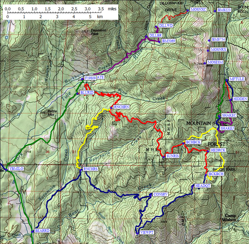
Here's a highway map showing the freeway exits and an overview. The two waypoints YBMILO and BEARRD are where this highway map matches the more detailed topo map below:
Here's a topo overview on which you can locate the maps and waypoints below. Be careful that your printer doesn't cut off the right side! The two waypoints YBMILO and BEARRD are where this topo map matches the highway map above:
Leave Hwy 99 (south of Visalia/Tulare) on Hwy 190 east, near the
town of Tipton (waypoint TIPTON). Go east through Porterville
(waypoint PORTER is at the intersection of Hwy 190 and Hwy 65.
Hwy 190 continues east to Springville via the Success Dam
and Pleasant Valley (waypoints SUCCES, PLESNT, TULERV). Continue
northeast from Springville for just under a mile until you see the
"Mountain Home State Forest" sign. Turn north (left)
onto Balch Park Road at the sign (waypoint BALCHR). Different maps
name the road leaving Hwy 190 differently! Some call it Bear Creek
Road, some call it J24, but the sign says Balch Park Road.
Click here for popup
highway or
area topo maps,
or scroll to the ones above.
Go north at waypoint BALCHR just east of Springville for all of the
trailheads described below. Bear Creek Road goes east and Balch Park
continues north about 6 miles from Springville (waypoint BEARRD).
Balch Creek Road stays fast and wide until after the Yokohl Vally Dr
turnoff (waypoint YBMILO) roughly another 2.5 miles north of Bear Creek Road.
Exit Hwy 99 at Hwy 198 (waypoint 099198), following signs for
Sequoia / Kings Canyon national park. Go through Visalia on freeway,
which is 65mph and below grade so you don't see anything like filling
stations or restaurants. Cross Hwy 63 at waypoint 198063 and continue
out of town - yes, that was Visalia you didn't see.
Click here for popup
highway or
area topo maps,
or scroll to the ones above.
Once the freeway ends, there are a couple of flashing lights so you don't drive
through the stop signs in the dense fog. There are a couple of filling stations
with fast food outlets at the stop signs, the last of which is at Hwy 245.
Two miles after Hwy 245 is an easy-to-miss right turn on Yokohl Valley Dr
(waypoint YOKOHL). There is a green sign saying Yokohl Drive and Balch Park
42 miles, but the best way to find it is either a GPS or keeping in mind that
Hwy 198 goes due east until Yokohl Drive. When 198 turns to the north,
you've gone to far.
At Myer Road there is a yellow "T" intersection sign,
and you must turn left to stay on Yokohl Valley Dr. This is
where the road starts to narrow and become twisty. It's all paved,
but very narrow and with corners that will scare some people
at 20mph. Once Yokohl Dr goes over Blue Ridge, it gets wider
but there are lots of ranch houses (not open country road).
Keep going on the main road until you reach a stop sign
(waypoint YBMILO) where Yokohl T's into a broad corner of the
much wider Balch Park Rd near the invisible town of Milo. At this
stop sign there is a sign saying Balch Park 19 miles to the left,
Bear Creek Rd intersection (waypoint BEARRD) 3 miles to the right,
Springville (waypoing SPRING) 6 miles to the right.
From waypoint YBMILO, turn left to reach the Dillonwood
trailhead, turn right to reach Mountain Home trailheads
(Hidden Falls and Shake Camp). Remember this
intersection on the way back or use a GPS to locate YBMILO -
it's easy to miss. About 2.5 miles further south on Balch Park Road
is a left turn on Bear Creek Road (waypoint BEARRD) if you're headed
to Shake Camp or Hidden Falls. Continue about 6 miles south past
Bear Creek Rd to Hwy 190 (waypoint BALCHR) and Springville (waypoint
SPRING) if you need food or gas.
See this 2013 trip report
for details of climbing Moses via the west face or north ridge.
Starting at waypoint YBMILO, near the tiny
town of Milo, go northeast staying on Balch Park Road.
(Northwest from Milo is Yohohl Valley Road toward Visalia,
south from Milo is Balch Park Rd toward Porterville.)
Follow the green line on the map above (Balch Park Rd) from waypoint
YBMILO to waypoint BLURID
and turn left (north) onto Blue Ridge Rd at a yellow "T" intersection sign.
Blue Ridge Rd soon crosses the North Fork of the Tule River.
(Staying on Balch Park takes you the
back way to Mountain Home and the Shake Camp or Hidden Falls trailheads,
but is winding and steep. If you start hitting hairpins and climbing out
of the drainage you'll know you missed the turn onto Blue Ridge Rd.)
The paved Blue Ridge Road goes across the North Fork of the Tule River
on a small bridge just over half a mile from Balch Park Road.
About a tenth of a mile beyond that bridge is a very small paved road
at a completely UNMARKED INTERSECTION - this is Forest Road 19S09
(waypoint F19S09). Check your mileage at the bridge, or use a GPS.
If you stay Blue Ridge Rd for a mile past the FS 19S09 turn, you'll
hit a cattle guard and a Sequoia National Forest sign together: if
so, you've gone too far and you should turn around!
From Blue Ridge Rd, turn right (northeast) on FS 19S09 and follow
this road to its end. A small marker stick says "FR 19S09"
after you've made the proper turn, and the cattle guard you cross
will be at a gate (waypoint NFGATE) that marks the National Forest
Boundary, but there will be no sign by the gate. The pavement ends
less than a tenth of a mile from Blue Ridge Rd, and the gate
(NFGATE) is about a quarter of a mile
from the Tule River bridge. High clearance vehicles can drive the
first three quarters of a mile from Blue Ridge Rd, but it's
very tough going past that. It was possible to get passenger cars
to the top in 2004, but they scraped hard on rocks and brush doing it.
In 2013 the road looked impassable without real 4WD, because deep
ruts with steep sides would lift one or more wheels.
There are no more junctions and you are never far from the river
as you follow this formerly-paved-but-now-4WD road to the Dillonwood
Entrance to Sequoia National Park. There are several unimproved
campsites near small creeks, the nicese of which is at the bridge
across Dillon Creek (waypoint DILLBR).
This is near where you leave the road (waypoint BM5069)
if you're doing the short route up the west face of Moses.
The Dillonwood trailhead and car camp area is at a permanently locked gate
(waypoint DILLWD), 5 miles up FR19S09 at the 5700'
hairpin corner. The gate may be closed, but lots of tracks indicate people
drive around it. Your fines may vary! A sign says "Dillonwood Entrance to
Sequoia National Park" and there is a single large bear box here, but there
are no other facilities.
Starting on Balch Creek Road (the green line on the
map below) turn northeast onto Bear Creek Road (the blue line on the
map below) at waypoint BEARRD, about 4 miles north of Hwy 190.
There is a sign at this intersection (waypoint BEARRD) pointing to
Mountain Home. Follow Bear Creek Rd northeast across Rancheria Creek
(waypoint RNCHRS) and then east to the conservation camp (waypoint CONSRV),
winds south to a great overlook (waypoint VIEWPT), to the Mountain Home
State Forest headquarters (waypoint HEADQT). This facility is closed in the
winter. Online and software maps are probably wrong in this area.
Follow the main road, follow the GPS waypoints provided here,
and keep looking for Balch Park or Shake Camp signs.
Don't get confused by Balch Park Road north of the headquarters. At
waypoint BCKBCH Balch Park Road goes north past Hedrick Pond (the
red line through waypoint HEDRCK) and off toward Sunrise Point (waypoint
SUNRIS) after intersecting Bear Creek Road again at waypoint BCHBCK.
That's not the road you want, unless you're looking for the Indian
Baths and the Giant Sequoias and such, but following it far enough
will eventually lead you back out to the nice part of Balch Park Road.
Hwy 99 to Hwy 190 to Balch Park Road - southern approach
GPS Route VIA PORTERVILLE
Hwy 99 to Hwy 198 to Balch Park Road - northern approach
GPS Route VIA VISALIA
Dillonwood Grove - Moses and Dennison from the west
GPS Route DILLONWOOD GROVE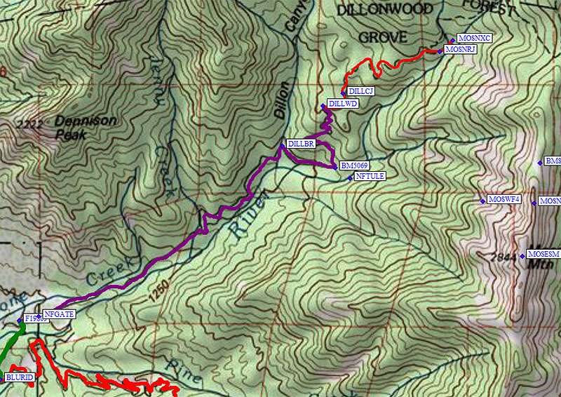
Shake Camp and Hidden Falls - standard Moses and Maggie approach
GPS Routes HIDDEN FALLS and SHAKE CAMP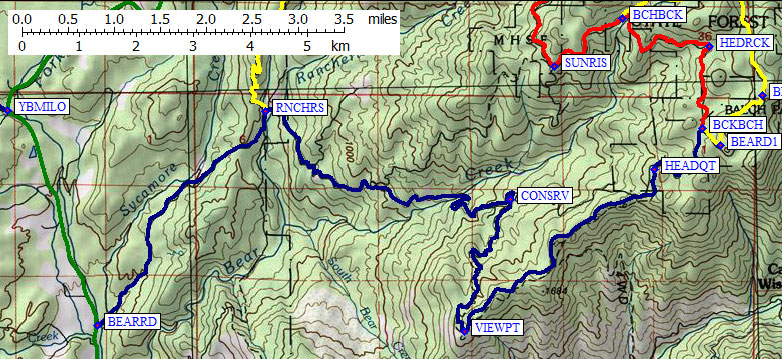
(continued at bottom of right map)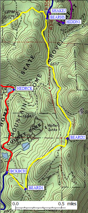
| To reach the Hidden Falls and Shake Camp trailheads, turn southeast
at waypoint BCKBCH and stay on Bear Creek Road past waypoints
BEARC1 and BEARC2 (the yellow line on the left map). Turn north (right)
onto a well-maintained dirt road at the junction with a sign for Shake Camp
(waypoint BEARHS, the blue line at the top of the left map). To reach Hidden
Valley Campground you go the same way at this point, but not for long!
The last road junction is at waypoint SHAKEJ, where you choose left (staying on the blue line at the top of the left map and the bottom of the right map) for Shake Camp or choose right (onto the purple line) for Hidden Falls. Waypoint HIDDN1 is provided only so your GPS points in the proper direction immediately after waypoint SHAKEJ if you are headed to the Hidden Falls trailhead. | 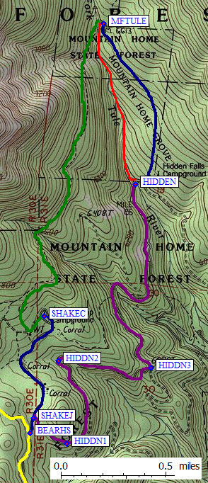 (continued from top of left map) |
There are THREE trails up the Middle Fork of the Tule River, only one of which is shown on any map I've seen. The three trails converge at waypoint MFTULE, which is an unsigned junction at a stream crossing. There are two parking lots for these three trails. It's no big deal which trail you take... unless you are coming down after dark. Taking the wrong trail downriver can leave you far from your car and the trail signs were vague or missing when I was last there. Pay attention on the way in!
The "Hidden Falls" are visible from the campground downstream from the road, not from the trail going uphill. They're very impressive and well worth the 5 minutes it takes to find them!
Useful Links: