Superstition Mountain and Weavers Needle
Revised 6 Mar 2014 - please send updates to the webmaster
For either trailhead, drive or fly to Phoenix, then take Hwy 60 east through Mesa and Apache Junction. The two trailheads leave Hwy 60 about two miles from each other, roughly 7 and 9 miles from Apache Junction.
Overview map: (see detailed maps for Superstition and Weaver's Needle below)
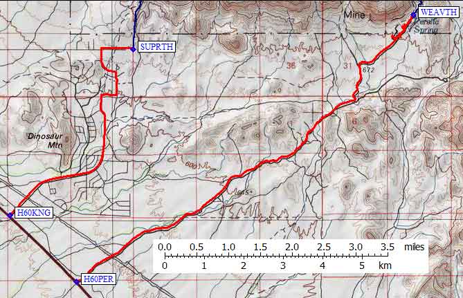
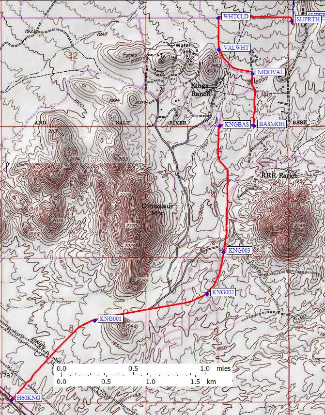
Turn north from Hwy 60 on Kings Ranch Rd (waypoint H60KNG), which is
roughly 7 miles southeast from Apache Junction. Ignore the DPS guide
instructions! The road is entirely paved, there is now only one
cattle guard, and there are trailhead signs at most intersections.
Follow the map below, using your GPS if you have one and are worried,
to the large parking lot at waypoint SUPRTH.
Driving map: (scroll down for climbing information)
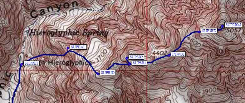
There is an information
sign and an obvious trail leading north up the canyon to the petroglyphs.
Leave the trail at the petroglyphs (waypoint SUPPET) and head east,
climbing up a small valley to the ridgeline 50 yards right of an
obvious balanced rock (waypoint SUPBAL). You more or less follow the
ridge from that rock to the summit. Around waypoint SUPSB1 the trail
cuts sharply left to go under a cliff face, and at waypoint SUP3RD
there is 10' of 3rd class climbing. Other than that it's a walkup!
The GPS waypoints file contains waypoints all the way to the summit,
which is most easily approached from the south on easy friction slabs.
Warning from Matt Hengst in 2012:
We had US Marshals pull us over and threaten to arrest us Easter morning
while coming out Peralta Road. I’d been told by the superstition wilderness
office we were fine accessing the trailhead without any sort of permit but
according to the guys with flak jackets and guns (yes, really) you need to
have a permit to even drive back there. Here's the
permit form.
You’re supposed to have the $15 Noncommercial & Noncompetative Group Permit.
Cash or check only sadly, though it claims you can go get it in Phoenix.
Superstition Mountain - GPS route SUPERSTITION MTN
Weaver's Needle - GPS route WEAVERS NEEDLE
|
Turn north from Hwy 60 on Peralta Rd (waypoint H60PER), which is
roughly 9 miles southeast from Apache Junction. Ignore the DPS guide
instructions! The road is paved as it goes past a school and new tract
housing. The pavement ends at waypoint PERPAV, and the rest of the
road is suitable for any vehicle.
Shortly after the pavement ends there is a sign that says the Peralta Trailhead is 7 miles away. At waypoint PERJCT turn left, following another sign for the Peralta Trailhead. Between the pavement and this sign, there are numerous turnouts which appears to be open camping. At waypoint PERCRN there is a parking area for Carney Springs Campground. Carney Springs Road is closed as of 2012, but this used to lead to a trailhead which got you to Superstition with about a 10 mile round trip trail hike and little or no cross-country hiking. The Peralta Trailhead road continues to the right from PERCRN. Go past the Lost Goldmine Trailhead (waypoint PERGLD), a day-use-only trailhead for a trail that's not on the map. | Most of the drive: (remainder of drive and climbing route are below)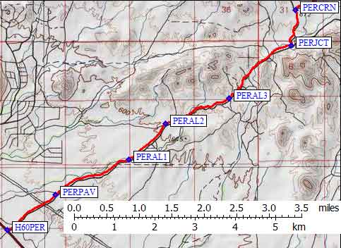
|
|
The former Peralta Campground is at waypoint PERCMP,
just before the cattle guard that marks the entrance to Tonto National Forest.
Matt Hengst says "It is damn easy to miss but once you pass the signed
Lost Goldmine Trailhead start looking on your right for a turnoff that barely
looks like a jeep started jumping over brush. There were about three sites
with fire rings and the only bathroom is a very badly maintained portapotty
off at the Lost Goldmine trailhead. Nice enough camping though."
You can drive a bit off the road to the southeast for some nice campsites with fire rings, or you can pull off to the northwest in open gravel that seems to be horse trailer parking now. There is a sign that might have been for the former campground, and some loops that might have been the campground itself, just inside the forest boundary. No fees are collected here or at the trailhead as of 2008. The road ends in a parking lot and nice restroom at waypoint WEAVTH, at the edge of the Superstition Wilderness. Ignore the confusing DPS guide wording about how to find the right trail. Go right at the first trail junction, then left at the next junction, to keep heading north (over Point 2958) to the saddle and trail junction at WEAVR4. Drop into the canyon on the east side of this ridge, toward Bluff Spring, paying attention at waypoint WEAVR6 to go right where the wash forks. The only good campsite we saw, if you wanted to camp out here, was at waypoint WEAVCS where there was some water and sand/gravel without thorns. The trail is in the wash between waypoints WEAVR6 and WEAVCS, and if you stay in the wash too long you will miss the trail as it climbs up the east canyon wall (pick it up before waypoint WEAVR7). Leave the trail at WEAVXC, go through vague washes to waypoint WEAVR9, and head for the ramp that ascends up and right toward the Needle's notch. At the white stripe of rock (waypoint WEAVWS) you'll need to stay right of a chockstone to the left of the stripe (bypass it on small ledges). The base east face (waypoint WEAVEF) is where the technical climb starts. | 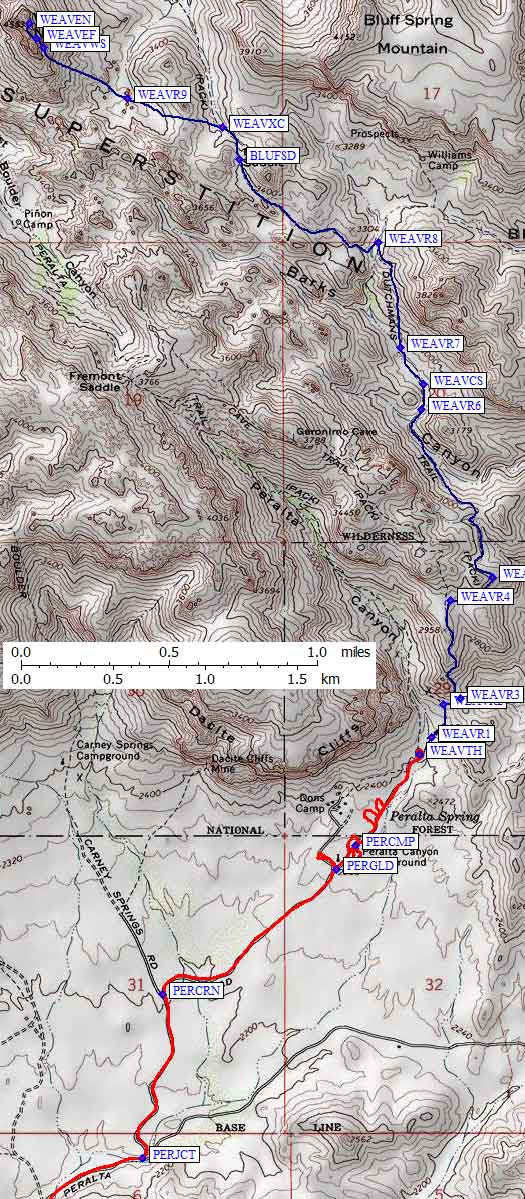
|
Useful Links: