Arc Dome and Mt Jefferson
Revised 8 Sep 2013 - please send updates to the webmaster
This trailhead page is for both Arc Dome and Mt Jefferson. Even though there is a considerable drive between them, enough people climb them on successive days that it's worth documenting the roads to and between them in the same place. Note that many of the roads described below are "Open Range"... take care not to hit half-ton cows that jump onto the road from nowhere after dark.
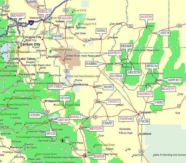
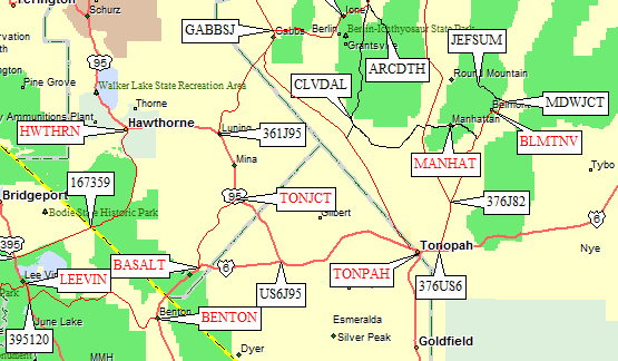
Here's an overview, including an area map:
Click on these links to jump to more details.
Area Map of Highways: (see links above for trailhead details)
Arc Dome from Jefferson - GPS route JEFFERSON TO ARC DOME
When driving from Jefferson to Arc Dome, it is possible to avoid
going all the way north to Hwy 50 or south to Hwy 6 by taking a dirt
road around Rainier Mtn. No, not Mt Rainier (the big tall snow-capped
volcano), THIS Rainier is only 6662'.
The Rainier Bypass - From Mt Jefferson to Arc Dome: (see area map above)
Refer to the instructions below for more details on the
Jefferson and Arc Dome trailheads.
Starting at Jefferson Summit, go east from the trailhead to Hwy 82 (waypoint MDWJCT),
then follow Hwy 82 south through Belmont (waypoint BLMTNV) to the Manhattan
turnoff (waypoint MAN082). Go east through Manhattan (waypoint MANHAT) to
Hwy 376 (waypoint MAN376). Go south on Hwy 376, turning west at a sign for
Peavine Canyon Campground (waypoint RAN376). This good dirt road, which
I have dubbed the Rainier Bypass can be taken slightly south and mostly
west around Rainier to Cloverdale Creek.
Bear left at RANBY6, where a sign for Peavine Canyon had the arrows
broken off in 2009, turning southwest at RANBY5. Follow the main road
to waypoint RANBY4, where it bends west to RANBY3 (which is close to Rainier,
that unspectacular lump to the north).
The road turns northwest and braids the split shown on some maps around
RANBY2 seems not to actually exist on the ground. Turn right (north) on
Hwy 21 at RANBY1, then go north through the grassy Cloverdale Ranch
area (waypoint CLVDAL). At a completely unmarked intersection just north
of the ranch (wayopint 21J427) stay right on Hwy 21 as it narrows and
follows Cloverdale Creek north.
At a cattle guard and intersection (waypoint 21J121) the road, never a
problem for passenger cars, improves as it enters a broad ranching valley.
Continue north past some houses associated with the Yomira Indian Reservation
(waypoint YOMIRA), and eventually the road along the Reese River goes from
dirt to pavement (waypoint REESEP) and reaches the turn-off for Arc Dome
(waypoint REESER) where you go east and south to the Columbine Campground.
Refer to the instructions below for more details on the
Jefferson and Arc Dome trailheads.
Arc Dome from Reno - GPS routes RENO TO REESE RIVER and REESE TO ARC DOME
From Reno through Gabbs to Reese River and the Arc Dome trailhead: (see area map above)
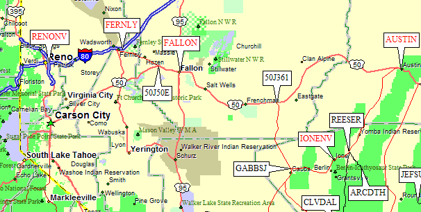
Go go east on I-80 to the town of Fernley (waypoint FERNLY), where
there are two exits from I-80 that both say Alt US 95 and one or both
exits say Alt US 50. There can be some reasonable confusion here!
Imagine an intersection of US 50 and Alt US 50, and then imagine
there are TWO highways each marked Alt US 50 and each intersecting
US 50 at different places! Nothing beats a waypoint for that situation.
Take Fernley Exit 48 south from I-80, following the brown sign for
Great Basin National Park. Enter a roundabout less than a mile south
of the freeway, watch the signs for the Fallon and Ely exit,
and take Alt US 50 east (waypoint FERN50). Go through Fallon
(waypoint FALLON) and turn south from US 50 on Hwy 361 at Middlegate
(waypoint 50J361). This junction is marked with Berlin and Ichthyosaur
signs, and seems to have a cafe/motel (which I didn't investigate).
From Gabbs to Reese River - part of GPS route RENO TO REESE RIVER
Matt Hengst adds in 2013: There's gas in Gabbs for those who need it though you have to chase down
the guy who runs the cafe. It was only 1 cent more expensive than Tonopah
and he even took credit cards. Hours were 'Monday though Saturday'.
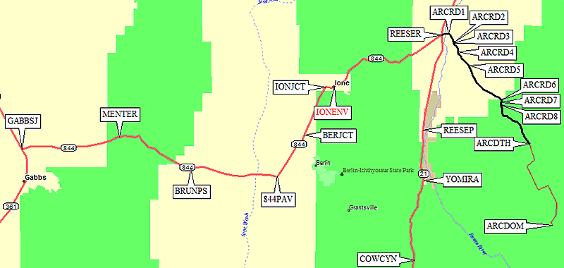
Turn east on Hwy 844 just north of Gabbs (waypoint GABBSJ) and
drive through Menter Canyon (waypoint MENTER), over Brunton Pass
(waypoint BRUNPS) into the next vally. When Hwy 844 turns north
the pavement ends (waypoint 844PAV) but the dirt road is excellent.
Those who have the DPS guide should note that this pavement break
is nowhere near the break described in the guide. Watch out for
the herds of pronghorn here! Go past the Berlin-Ichthyosaur park
turnoff (waypoint BERJCT) and through the town of Ione (waypoint IONENV).
Just west of Ione there is a junction (waypoint IONJCT) that's
almost not noticeable when heading east toward the peak. When
heading west toward Gabbs, however, you must turn south following
the sign for Berlin Ichthyosaur State Park. There is about 1.5 miles of
paved road around Ione (waypoints IONEPE to IONEPW), then it's
back to dirt road suitable for all vehicles. The road goes over
a pass and down into the Reese River valley where it ends at
Hwy 21 (a few yards south of waypoint REESER).
Coming from Ione, the intersection with Hwy 21 is poorly marked
but you'll jog left (north) a few yards on Hwy 21 to reach the
trailhead turnoff. Heading south on Hwy 21, the turn southwest
toward Ione (a few yards south of waypoint REESER) is marked
for Ione and Gabbs, and is slightly south of where the road to
Columbine Campground intersects Hwy 21 (at waypoint REESER).
From Gabbs to Reese River and the Arc Dome trailhead: (see area map above)
From Reese River to Arc Dome Trailhead - GPS route REESE TO ARC DOME
There is no sign at the intersection where you leave Hwy 21 for
the Arc Dome trailhead (waypoint REESER), but immediately after
you turn east you should see a Hwy 2 sign. This paved road crosses
the Reese River near Hwy 21, then bends southeast (waypoint ARCRD1).
Follow the pavement around that bend... but don't go too far!
Turn right on a dirt road marked Columbine Campground (waypoint ARCRD2).
This road fords Clear Creek (waypoint ARCRD3), then immediately bears
left (at another Columbine Campground sign) to follow the south side
of Clear Ck on the north and east of a significant ridge.
Keep straight at waypoint ARCRD4, where the roads don't match
the USGS maps. Look for a sign that says Road 119 and follow the
main dirt road. Note the fork at waypoint ARCRD5, which isn't
obvious on the way in but requires you to bear left on the way out.
Follow the sign to Stewart Creek. Turn right toward Stewart again
at waypoint ARCRD6, marked as Road 119, and ford Stewart Creek at
waypoint ARCRD7. Keep left on the main road at ARCRD8, again following
the sign for Road 119.
The Columbine Campground and the trailhead for the Toiyabe Crest Trail
are at the end of the road (waypoint ARCDTH at 8600'). The trail leaves
south from between the first two campsites on the right-hand campground
loop, just uphill from the outhouse. Camping is free, there are fire
rings and picnic tables but no water.
For details of the climb, refer to my 2009 trip report.
Arc Dome from Lee Vining - GPS routes LEE VINING TO REESE and REESE TO ARC DOME
Proof is left to the student that these directions can work in the other direction!
Proof is left to the student that these directions can work in the other direction!
|
From the intersection of Hwy 120 and Hwy 395 in Lee Vining (waypoint LEEVIN),
go north a few miles on Hwy 395 and turn east on Hwy 167 (waypoint LUN395).
Hwy 167 becomes Hwy 359 at the state line (waypoint 167359), and Hwy 359 turns north to Hawthorne (waypoint HWTHRN). Turn east on Hwy 95 in Hawthorne, following it to Hwy 361 (waypoint 361J95), then turn north on Hwy 361 about halfway to US 50 at the mining town of Gabbs. Matt Hengst adds in 2013: There's gas in Gabbs for those who need it though you have to chase down the guy who runs the cafe. It was only 1 cent more expensive than Tonopah and he even took credit cards. Hours were 'Monday though Saturday'. Just north of Gabbs (waypoint GABBSJ) turn east on Hwy 844 and follow the Gabbs - Reese River - Arc Dome instructions above. |
From Lee Vining through Gabbs to Reese River and the Arc Dome trailhead: (see area map above)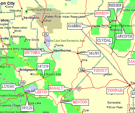
|
Arc Dome from Bishop - GPS routes BISHOP TO BENTON, BENTON TO REESE and REESE TO ARC DOME
|
From the intersection of Hwy 6 and Hwy 395 in Bishop, go north on Hwy 6
through Benton (waypoint BENTON) to the tiny village of Basalt (waypoint BASALT).
From Basalt, take Hwy 360 to Tonopah Junction (waypoint TONJCT), not to be confused with the TOWN of Tonopah! Take Hwy 95 north to the intersection with Hwy 361 (waypoint 361J95), and follow Hwy 361 about halfway to US 50 at the mining town of Gabbs. Matt Hengst adds in 2013: There's gas in Gabbs for those who need it though you have to chase down the guy who runs the cafe. It was only 1 cent more expensive than Tonopah and he even took credit cards. Hours were 'Monday though Saturday'. Just north of Gabbs (waypoint GABBSJ) turn east on Hwy 844 and follow the Gabbs - Reese River - Arc Dome instructions above. |
From Lee Vining through Gabbs to Reese River and the Arc Dome trailhead: (see area map above)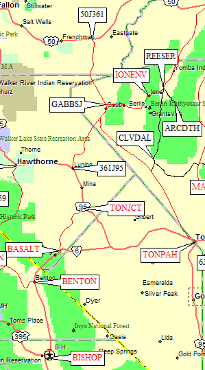
|
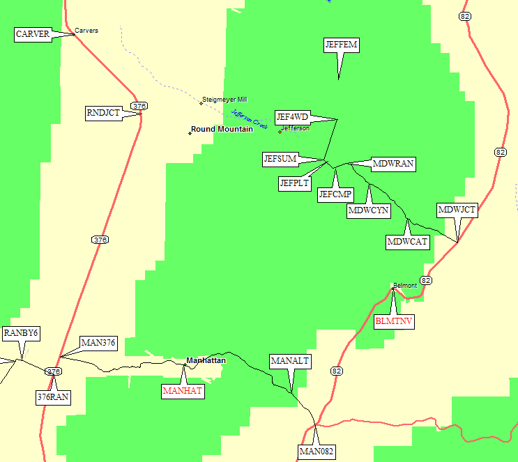
Jefferson from Reno - GPS routes RENO TO BELMONT and BELMONT TO JEFFERSON
From Reno through Austin and Manhattan to Belmont and the Arc Dome trailhead: (see area map above)
Go go east on I-80 to the town of Fernley (waypoint FERNLY), where
there are two exits from I-80 that both say Alt US 95 and one or both
exits say Alt US 50. There can be some reasonable confusion here!
Imagine an intersection of US 50 and Alt US 50, and then imagine
there are TWO highways each marked Alt US 50 and each intersecting
US 50 at different places! Nothing beats a waypoint for that situation.
Take Fernley Exit 48 south from I-80, following the brown sign for
Great Basin National Park. Enter a roundabout less than a mile south
of the freeway, watch the signs for the Fallon and Ely exit,
and take Alt US 50 east (waypoint FERN50). Go through Fallon
(waypoint FALLON) and Austin (waypoint AUSTIN).
Austin bills itself as "The most isolated town in the contintal US",
and a sign on the cafe there says US 50 is the "loneliest road in the nation".
There are hotels and restaurants and gas stations here. Last chance!
Turn south from Hwy 50 onto Hwy 376 (waypoint 50J376) at signs for
Tonopah and Round Valley. Hwy 376 is paved. We chickened out on Belmont Road
because other reports indicated it might be a bad unpaved road, so this
route description involves driving around the south end of Jefferson's range.
From Hwy 376 to Belmont - part of GPS route RENO TO BELMONT
What looks like the village of Carvers has a restaurant and rest stop,
but if you need gas or supplies go just south of town (waypoint CARVER)
to the saloon / restaurant / filling station. Carvers seemed to have
the only services anywhere near here. We didn't go over to the mining
town of Round Mtn (waypoint RNDJCT).
Continue south on Hwy 376 to the Manhattan turnoff (waypoint MAN376)
marked Nevada 377 with a sign indicating 19 miles to Belmont.
Stay left at the 'Y' intersection on the east edge of Manhattan
(waypoint MANHAT) to continue over the pass to Hwy 82 and Belmont.
There appeared to be no services of any kind in Manhattan. It's more
ramshackle than ghost town, and the pavement ends just east of town.
The dirt road is OK for any vehicle.
At waypoint MANALT there is a good dirt road that heads northeast, but
we continued southeast and downhill on the slightly wider main road
that drops to Hwy 82 (at waypoint MAN082). The alternate may be shorter,
but it's not on my maps and we didn't try it out.
Turn north on Hwy 82 (waypoint MAN082), which is paved. This intersection
can also be reached by heading east from Tonopah (waypoint TONPAH) on Hwy 6,
then north on Hwy 376 (waypoint 376US6), and continuing north on Hwy 83
(waypoint 376J82).
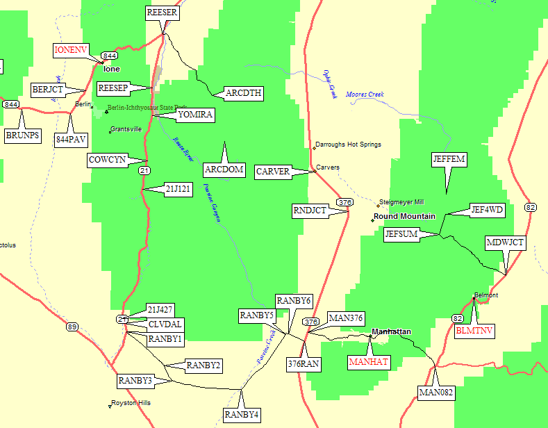
From Hwy 376 to Belmont and Jefferson Summit:
(see area map above
and trailhead detail map below)
From Belmont to the Jefferson trailhead: - GPS route BELMONT TO JEFFERSON
Go north on Hwy 82 to the cute town of Belmont Nevada. The
town appears to be a vacation and dude ranch sort of a place, well
kept with a rest stop and saloons (waypoint BLMTNV, southwest of
where the map shows the old town) plus a classic church on the hill.
As with Manhattan, the pavement ends at the east edge of town.

|
Past the ranger station turnoff the road worsens again, becoming
rocky and bumpy but still passenger-car accessible.
A dirt side road leads a short distance to some reasonable campsites
(waypoint JEFCMP) out of the way and out of the wind compared
to camping at Jefferson Summit. Matt Hengst adds in 2013: We camped at the Camp Jefferson waypoint. There were a number of good spots though we should have continued on to the next rise for something
slightly more protected. No fire rings but we had a pit.
There is a steep rocky place near waypoint JEFPLT, which may stop passenger cars, and then you're on the plateau-like pass called Jefferson Summit (waypoint JEFSUM at 8800'). Just before the road drops on the west side of Jefferson Summit, turn north on the 4WD road that drops slightly as it heads toward the peak (waypoint JEFSUM). Passenger cars should park near this intersection or soon after it (no further than waypoint JEF2WD, and even getting there may be risking your passenger car). The track starts climbing steeply, gets more rocky, and crosses from west of the fence to east of the fence (waypoint FENCEX at 8900'). There is no gate and there are no signs indicating which side of the fence (if any) is private land. You can stop there, or continue up the east side of the fence line to an outcropping where even good 4WD vehicles must stop (waypoint JEF4WD at 9400'). For details of the climb, refer to my 2009 trip report. NOTE: The inconsistencies in the DPS Guide mileages appear to center on whether you drive all the way to 9400' or stop at the fence crossing. |
Details of the Jefferson trailhead: (see area map above)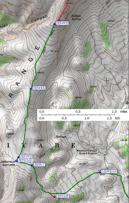
|
Jefferson from Lee Vining - GPS routes LEE VINING TO BENTON,
BENTON TO BELMONT and BELMONT TO JEFFERSON
From Lee Vining to Jefferson: (see area map above)
From the intersection of Hwy 120 and Hwy 395 in Lee Vining (waypoint LEEVIN),
go south a few miles on Hwy 395 and turn east on Hwy 120 (waypoint 395120).
From the intersection of Hwy 120 and Hwy 6 in Benton (waypoint BENTON),
go north on Hwy 6 through the tiny village of Basalt (waypoint BASALT).
Stay on Hwy 6 as it turns east through the town of Tonopah (waypoint TONPAH),
not to be confused with Tonopah JUNCTION!
A few miles east of Tonopah, go north on Hwy 376 (waypoint 376US6),
following it to the intersection of Hwy 376 and Hwy 82 (waypoint 376J82),
where you branch right (northeast) on Hwy 82.
Once on Hwy 82, follow the Belmont to Jefferson instructions above.
Jefferson from Bishop - GPS routes BISHOP TO BENTON,
BENTON TO BELMONT and BELMONT TO JEFFERSON
|
From the intersection of Hwy 6 and Hwy 395 in Bishop, go north on Hwy 6
through Benton (waypoint BENTON) to the tiny village of Basalt (waypoint BASALT).
Stay on Hwy 6 as it turns east through the town of Tonopah (waypoint TONPAH), not to be confused with Tonopah JUNCTION! A few miles east of Tonopah, go north on Hwy 376 (waypoint 376US6), following it to the intersection of Hwy 376 and Hwy 82 (waypoint 376J82), where you branch right (northeast) on Hwy 82. Once on Hwy 82, follow the Belmont to Jefferson instructions above. |
From Bishop to Jefferson: (see area map above)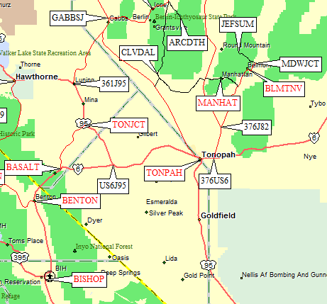
|
Useful Links: