Picacho Peak in California
Revised 17 Apr 2013 - please send updates to the webmaster
"Picacho" means "big peak" in Spanish! This isn't the only place named Picacho, and it's not the same as Picacho Peak State Park in Arizona.
|
I-8 passes north of Yuma, crossing between California and Arizona
on a bridge over the Colorado River. The first exit on the California
side (waypoint WINJI8) is marked for Winterhaven... but you're not
headed for either the road or the town with that name! Winterhaven Drive
actually connects the first two California exists, so don't be confused.
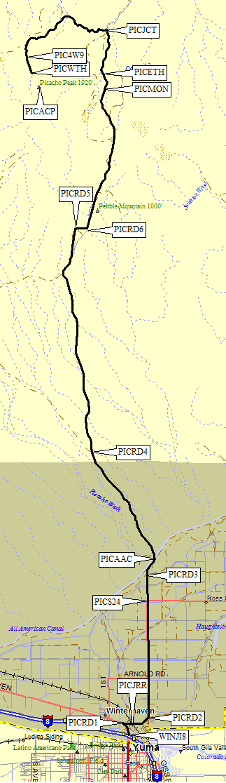
Take Exit 171 from I-8 (waypoint WINJI8, the first one on the California side) and go north 0.3 miles to the first intersection (waypoint PICRD1). We saw no street name signs. Turn sharply right at that first stop. Immediately after you complete this hairpin, there's an S24 sign confirming you're on State Route 24, also known as Picacho Road. Go 0.2 miles and bear left at the next intersection (waypoint PICJRR). There is a green sign, easily missed, that says Picacho across the intersection as you approach from the freeway. Look for the low railroad bridge which Picacho Road goes under. Follow Picacho Road east and northeast 0.4 miles until it turns due north (waypoint PICRD2). Go north past a school and straight through a stop sign, still seeing S24 signs but really following Picacho Road. Continue straight north past the sign where S24 turns right (waypoint PICS24, 4.3 miles from I-8). S24 goes to Ross Corners and past the Imperial Dam, eventually leading you to Hwy 85 - this is a nice shortcut if you're headed to Castle and Signal and don't want to go back to Yuma. At waypoint PICRD3 the pavement ends and a green sign says "County of Imperial / Picacho Landfill". Further on, a brown sign says "Picacho State Recreation Area Ahead". Continue straight north until the road bends northeast (waypoint PICRD3) along the All American Canal for a short distance. Go aross the Picacho Wash flume 5.5 miles from I-8 and turn left at the yellow 15mph arrow (waypoint PICAAC) to cross the canal. As a side note, I think it's odd that a canal has to be protected from the influx of water from a wash, and that the wash's water flows OVER the canal but under the road! See Google Maps for a satellite image. Picacho Rd is gravel, very wide, with fairly bad washboards here. It will narrow slowly as you go north. Stay right at the firstfork in the road (waypoint PICRD4, 8.7 miles from I-8) following the sign to Picacho. The road no longer follows the maps, going across "Unnamed Wash" at the PICRD5-6 dogleg 15 miles from I-8. A sign says Picacho State park is now 9 miles away. PICRD5 is a great overlook, and you can see Picacho Peak from here. The road again diverges from the map at Picach Mine about where a chain link fence with razor wire appears to the west (waypoint PICFEN). The unsigned mine entrance (waypoint PICMIN) doesn't seem to be where the DPS Guide indicates it should be... and there is no sign like the DPS Guide says there will be! Don't bet on their mileages. Soon there's ANOTHER recreation area sign, this time with a boating symbol on it. Yes, people drag boats up this bumpy dusty road! The final marker for the mine area is a monument across from the chain link fence (at waypoint PICMON). The mine was opened by placer miners extracting gold after 1852. (Apparently gold and copper are often found near each other, which explains all the green rocks around the trailhead.) The monument is 19.2 miles from I-8. |
|
Those who (like us) wanted to be as lazy as possible about the approach hike will continue north past waypoint PICETH. Hopefully you'll do better than we did at spotting the turnoff now that you have solid GPS waypoints. If you see a sign for the Picacho State Rec Area boundary, like we did, you've gone about 1.3 miles too far! Turn around and go 1.3 miles south to PICJCT.
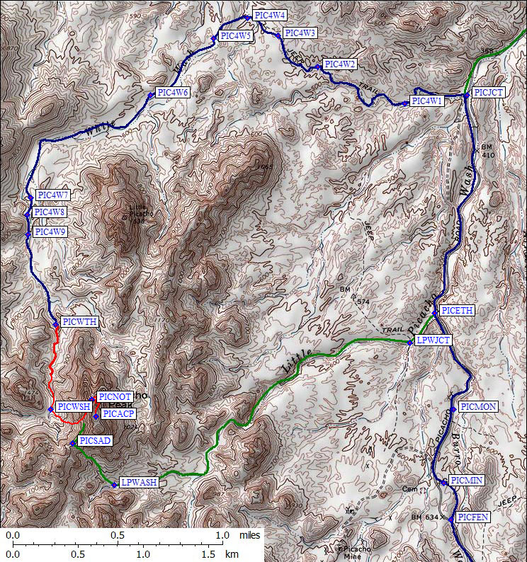
1.7 miles north from the mine monument (at waypoint PICJCT) there are TWO dirt tracks leaving the main road... but there's a twist. Between the main road (Picacho Road, but it hasn't said that for miles) and the 4WD road (A659, but not signed) you have to go across a 75 foot wide graded gravel area after driving over a foot high berm of graded sand along the main road! There's no way this looks like an intersection. At night your headlights won't shine far enough sideways to see the 4WD road.
The correct side road, slightly north of the wrong one, has a sign WELL BACK FROM THE MAIN ROAD (remember that 75' gap and the 1' berm?). This sign doesn't give a road number, it just says Limited Use Area. You won't see the Limited Use sign until you've already turned! The wrong side road has no sign at all. (The DPS Guide says there will be an A278 sign, but it wasn't there in 2009 and we NEVER saw ANY sign with the number 278 on it.) John, without a GPS, took the wrong road which goes southwest instead of due west, and he wandered all over the place before finding the trailhead. He's sure the DPS mileage directs you to the wrong one.
In the Limited Use Area, vehicles must stay on marked routes. Good luck! There are lots of branches here. Hopefully the GPS track log and waypoints will help. We made only one or two wrong turns, and quickly discovered our mistakes. If we had not been driving at night it would have been much easier. This road had some soft sand, some rocks, and some places with serious clearance requirements. Definitely not a 2WD road (as the DPS Guide indicates), although 2WD pickups with great clearance might be able to get most of the way.
OK, so here's the turn: Go west at PICJCT, 21 miles from I-8, on the northernmost track, the one with the Limited Use sign. Remember there is no sign saying which road you're turning on.
The 4WD road Winds thru badlands, going west, southwest, and finally a short south stretch to the trailhead. You're driving around the peak. Ignore the side road going south in smaller wash at PIC4W1 - stay in the main east-west wash here. At PIC4W2 (21.8 miles from I-8) we followed an arrow on a sign saying road A659 and took the left fork of a poorly defined junction (staying in the wash). We never saw any sign with road 278 on it, but we saw several signs saying road A659. Follow those. Ignore the DPS Guide.
At PIC4W3 we re-joined the fork that had split off at PIC4W2 (0.3 miles earlier). Be sure to take the right one on the way out - the other one is a dead end. This braided road, and probably others, are re-routes around wash-outs. Waypoint PIC4W4 is the northernmost point of the drive, where you turn southwest. At waypoint PIC4W5 we dropped into "White Wash" and turned left - this junction was easy to miss on the way out since a track continued northeast in White Wash. There's an A659 stake visible while driving out, but it's off to the side.
At waypoint PIC4W6 (23 miles from I-8) there were tracks up out of the wash - don't be fooled! The DPS Guide describes the road as climbing 'steeply out of the wash' at some point, but all side tracks match that. At waypoint PIC4W7 (23.9 miles from I-8) there was a fork in the road, and we climbed out of the wash on the right. At waypoint PIC4W8 we came back down into what seemed to be a DIFFERENT wash, with another road A659 sign. We missed this sign on the way out, when it's a right turn up a sharp hill with a sign behind a bush, and the GPS told us to go back.
The final fork is at waypoint PIC4W9, 24 miles from I-8. This is the 2WD trailhead, if you're a gonzo pickup driver. Otherwise it's the 4WD trailhead. When we first got there, going straight in the wash seemed ridiculously hard, so we took the right branch and climbed out of the wash. Wrong. Doesn't go to toward the peak. We camped at the junction, where there's a shade tree and nice flat sand.
The Jeep Cherokee wasn't confident about going on to what the DPS Guide calls a 2WD trailhead. The Toyota FJ Cruiser bottomed out 3-4 times but got us to the ultimate west-side trailhead at waypoint PICWTH. It's less than a half mile further, 100' higher, and probably not worth risking your vehicle.
|
Note that the peak is NOT where the USGS map shows it, it's at the south end
of the ridge beyond the famous rap notch. I corrected the waypoints for this
trailhead file and roughly drew a better line to the summit in 2013 because
'hwstock' says: I'm guessing the waypoint listed for the summit was picked off the usgs map after the trip. The map is very wrong. See SummitPost for a description and photo of the error. | 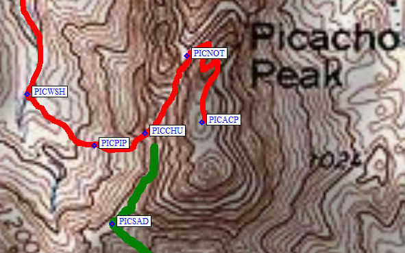
|
Useful Links: