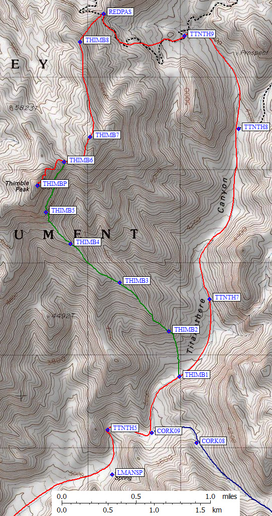
See more detailed maps below, with waypoints and a link to interactive waypoints map!
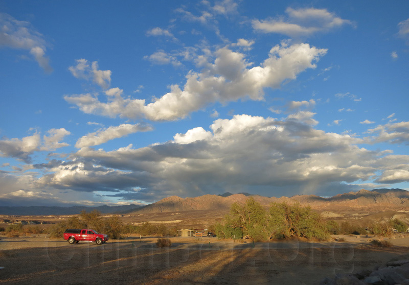
Walking up the Titanothere Canyon alluvial fan (from waypoint TTNTH1) wasn't bad in terms of brush and sand, but one needs to stay on the higher islands with the smaller rocks (think gravel with cement) rather than down in the washes (think grapefruit) to make good time. I dragged that overly heavy pack a mile or two and settled into a small hollow just as full darkness fell. It had been 80 degrees at 5pm, and was still 70 degrees at 7pm. The ground felt warm through my pad all night!
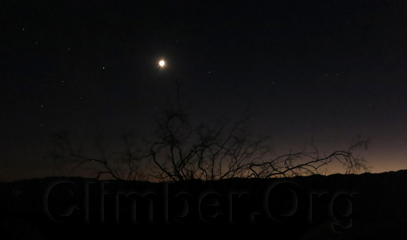
Time exposure, taken after the sky was completely black to the naked eye.
It was hotter than I like, so when I found a dike that cut across the canyon (waypoint TTNTH5), providing both level sand and afternoon shade... well, I called it a day and napped in perfect silent solitude. 3000' was plenty of gain for a cross-country backpack day, but it really didn't feel like that much because the footing was great and I stopped often to take the weight off my back. By the way, Lost Man Spring (waypoint LMANSP) has trees and bushes, but I failed to find any running or pooled water or even any real shade.
Look closely for my camp in the shadow of this canyon-shaping dike.
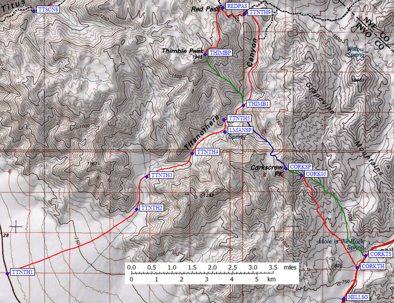
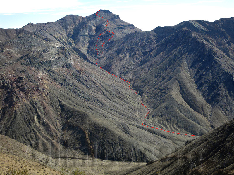
Up at dawn the next day, I headed east (leaving Titanothere at waypoint CORK09) and then southeast in a canyon below the north ridge of Corkscrew (the red line on the picture immediately below, the blue line on the map at the bottom). Again there was great footing with little or no brush. The canyon steepens and I picked my way through some outcroppings to the 4800' saddle (waypoint CORK06) northwest of the peak. The cliff bands that make the screwtop on Corkscrew are as easy to breach on this side as on the standard route. I sidehilled a bit under a cliff band, to a weak spot where I easily gained the summit ridge.
My route up Corkscrew, drawn on a picture taken near Thimble.
The top (waypoint CORKSP) has a nice view, and I contemplated trying for Thimble the same day. I had 4 days food and water, and I rather like being away from civilization, so I ended up doing another siesta for the hot part of the day. The days were just right in the shade, the nights were windless and my 45 degree bag was more than warm enough. How often does that happen?
I started up Titanothere Canyon well before dawn, reaching the Titus Canyon road (waypoint TTNTH9) before the sun actually touched me. There were thin clouds the evening before and again this morning, but it was still another perfect day.
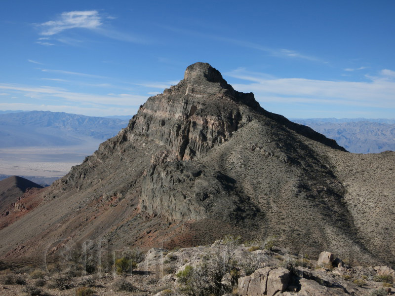
The upper part of Thimble, from the bump northeast of the saddle.
I went to Red Pass (waypoint REDPAS), cutting switchbacks on the Titus Canyon road, and followed the faint use trail from there south along the ridge. There's a significant drop just before the peak (from waypoint THIMB7 to THIMB6) and a bunch of ledges on the final approach (which is mostly to climber's right of the ridge line but has one semi-exposed area left of the ridge). The good views are to the north, between Titus Canyon and the Palmer-Grapevine area which is wooded.
Coming down I wanted to take a shorter route I had scoped out on the way up, so from the saddle (waypoint THIMB6) I traversed under the southeast face of Thimble to a prominent southeast ridge (waypoint THIMB5). Wow. Tough going! It's not scree, it's rubble on hard clay and it will slice you to shreds if you fall. Still, once on that ridge (where there is a HUGE cairn with no apparent purpose) it's a cake-walk from 5000' down into the canyon (waypoint THIMB1). You could ride a bike down it, and it's miles shorter! See the green line south and east of Thimble Peak on the map at the bottom.
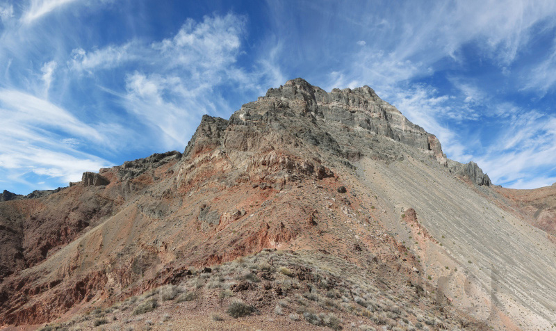
The upper part of Thimble, from the ridge southeast of the peak.
I took a long break in camp, then packed all the way out. The clouds were increasing, and the weather update I got by sat phone indicated rain was coming. I didn't want to be in that canyon when it turned loose, but I didn't get to my car until well after dark. Hard to be efficient when you can only see as far as a headlamp will travel in rolling washes, and in the end the rain didn't show up until the next evening so I could have stayed longer.
After a layover day, I made my way to the DPS List Finish group campsite where we sweltered in the heat until late at night when the wind came up and filled our tents with sand.
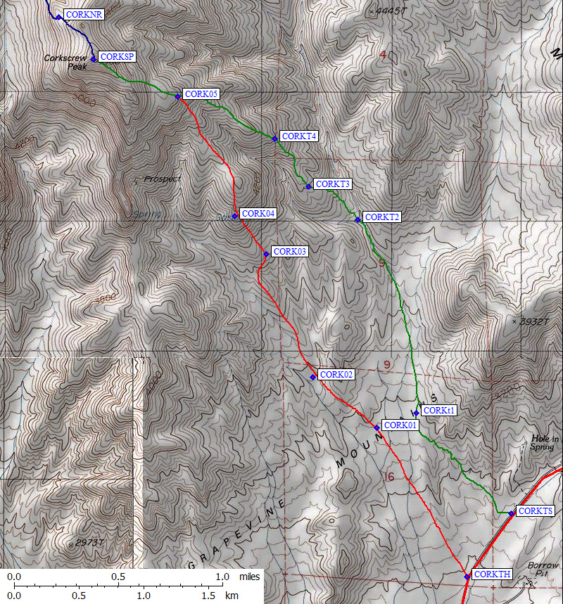
Saturday's climb of Corkscrew was made less chaotic by splitting the group into two, one doing the traditional DPS route (from waypoint CORKTH) and the other walking up the trail from a sign on the highway (the green line going northwest from waypoint CORKTS on the map at the bottom). It was cold and windy, a huge change from the hot and calm conditions I had on my backpack trip.
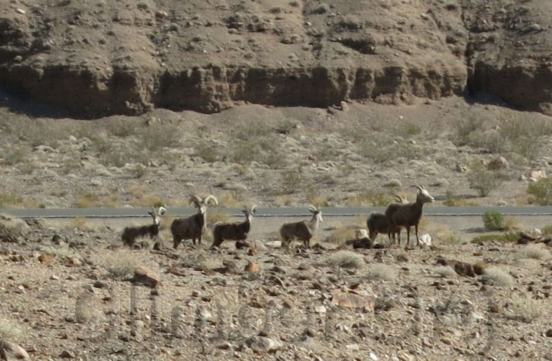
Sheep near Daylight Pass Road.
That evening the campsite was nicely cooler, and we watched with envy as rain soaked the ridge to our east. The wind kicked up again, we had no campfire, and many people cut out early to drive home instead of dealing with blowing sand. A group of young men pulled up in the neighboring group site and blasted their car stereo at midnight. Sigh. Can't wait to camp in a developed campsite again!
Brief showers overnight left the air clear for a beautiful drive home the next day.
Datum,North America 1983,GRS 80,0,-1.6E-7,0,0,0
RouteName,1 ,TITANOTHER CYN
RoutePoint,D,TTNTH1, 36.7326600552,-117.1294499636,10/26/2014,01:59:02,TITANOTHERE PAVED PULLOUT 100
RoutePoint,D,TTNTH2, 36.7558699846,-117.0712499619,10/26/2014,02:00:12,1600
RoutePoint,D,TTNTH3, 36.7677099705,-117.0667500496,10/26/2014,02:00:41,2000
RoutePoint,D,TTNTH4, 36.7761800289,-117.0462399721,10/26/2014,02:01:15,2600
RoutePoint,D,LMANSP, 36.7839100361,-117.0314699411,10/26/2014,02:01:37,LOST MAN SPR 3100
RoutePoint,D,TTNTH5, 36.7882399559,-117.0319800377,10/26/2014,02:01:57,3200
RoutePoint,D,CORK09, 36.7879699469,-117.0266499519,10/26/2014,01:58:14,TITANOTHER CYN 3300
RoutePoint,D,THIMB1, 36.7934499979,-117.0232800245,11/17/2014,21:30:20,SOUTH RIDGE TO THIMBLE
RoutePoint,D,TTNTH7, 36.8009699583,-117.0196599960,10/26/2014,02:02:26,3800
RoutePoint,D,TTNTH8, 36.8175300360,-117.0161299706,10/26/2014,02:02:44,FORK AT 4300
RoutePoint,D,TTNTH9, 36.8265999556,-117.0226600170,10/26/2014,02:03:57,JCT TITUS CYN RD
RouteName,2 ,CORKSCREW PK DPS
RoutePoint,D,CORKTH, 36.7347500324,-116.9719899893,03/04/2008,17:30:41,CORKSCREW TH 2600
RoutePoint,D,CORK01, 36.7450900078,-116.9797500372,03/04/2008,17:30:42,CORK01
RoutePoint,D,CORK02, 36.7486200333,-116.9852900505,03/04/2008,17:30:42,CORK02
RoutePoint,D,CORK03, 36.7571500540,-116.9893200397,03/04/2008,17:30:41,CORK03
RoutePoint,D,CORK04, 36.7597899437,-116.9920699596,03/04/2008,17:30:41,CORK04
RoutePoint,D,CORK05, 36.7681200504,-116.9969899654,03/04/2008,17:30:41,CORK05
RoutePoint,D,CORKSP, 36.7706999779,-117.0042599440,01/26/2008,10:29:40,2_14 CORKSCREW PK 5804
RoutePoint,D,CORKNR, 36.7736500502,-117.0072300434,10/26/2014,01:55:53,NORTH RIDGE 5600
RoutePoint,D,CORK06, 36.7755700350,-117.0109599829,10/26/2014,01:56:30,5000
RoutePoint,D,CORK07, 36.7783800364,-117.0101300478,10/26/2014,01:57:16,4600
RoutePoint,D,CORK08, 36.7870099545,-117.0212199688,10/26/2014,01:57:48,3600
RoutePoint,D,CORK09, 36.7879699469,-117.0266499519,10/26/2014,01:58:14,TITANOTHER CYN 3300
RouteName,3 ,CORKSCREW PK TRAIL
RoutePoint,D,CORKTS, 36.7391599417,-116.9681500196,11/17/2014,05:50:22,CORKSCREW TH WITH SIGN 2700
RoutePoint,D,CORKt1, 36.7461199760,-116.9763699770,11/17/2014,05:54:04,CORKt1
RoutePoint,D,CORKT2, 36.7595900297,-116.9814100266,11/17/2014,05:54:40,CORKT2
RoutePoint,D,CORKT3, 36.7618900537,-116.9856300354,11/17/2014,05:55:01,CORKT3
RoutePoint,D,CORKT4, 36.7651799917,-116.9885499477,11/17/2014,05:55:12,CORKT4
RoutePoint,D,CORK05, 36.7681200504,-116.9969899654,03/04/2008,17:30:41,CORK05
RoutePoint,D,CORKSP, 36.7706999779,-117.0042599440,01/26/2008,10:29:40,2_14 CORKSCREW PK 5804
RouteName,4 ,THIMBLE PEAK
RoutePoint,D,THIMB1, 36.7934499979,-117.0232800245,11/17/2014,21:30:20,SOUTH RIDGE TO THIMBLE
RoutePoint,D,THIMB2, 36.7978600264,-117.0245599747,11/17/2014,21:31:29,
RoutePoint,D,THIMB3, 36.8025799990,-117.0305199623,11/17/2014,21:31:47,
RoutePoint,D,THIMB4, 36.8063499928,-117.0364799500,10/26/2014,19:02:04,5200
RoutePoint,D,THIMB5, 36.8094199896,-117.0394799709,11/17/2014,21:32:33,TRAVERSE
RoutePoint,D,THIMBP, 36.8120000362,-117.0405000448,10/26/2014,02:13:20,2X24THIMBLE PK 6381
RoutePoint,D,THIMB6, 36.8142999411,-117.0372799635,10/30/2014,17:14:34,TRAVERSE OR RIDGE
RoutePoint,D,THIMB7, 36.8167699575,-117.0341099501,10/26/2014,19:00:24,6100
RoutePoint,D,THIMB8, 36.8259899616,-117.0353399515,10/26/2014,19:00:06,5700
RoutePoint,D,REDPAS, 36.8287299871,-117.0324699879,10/26/2014,02:06:36,RED PASS 5200
RouteName,5 ,TITUS CYN
RoutePoint,D,TTSCN1, 36.8593000174,-116.8456699848,10/26/2014,02:04:45,TITUS CYN EAST END PAVEMENT 3400
RoutePoint,D,TTSCN2, 36.8470300436,-116.9546500444,10/26/2014,02:05:22,TTSCN2
RoutePoint,D,TTSCN3, 36.8243299723,-116.9821499586,10/26/2014,02:06:02,TTSCN3
RoutePoint,D,TTSCN4, 36.8286399841,-117.0079599619,10/26/2014,02:06:21,JCT TITANOTHER CYN
RoutePoint,D,TTNTH9, 36.8265999556,-117.0226600170,10/26/2014,02:03:57,JCT TITUS CYN RD
RoutePoint,D,REDPAS, 36.8287299871,-117.0324699879,10/26/2014,02:06:36,RED PASS 5200
RoutePoint,D,TTSCN5, 36.8341300488,-117.0329300165,10/26/2014,02:07:51,TTSCN5
RoutePoint,D,TTSCN6, 36.8361300230,-117.0465500355,10/26/2014,02:07:57,TTSCN6
RoutePoint,D,LEDFLD, 36.8481299877,-117.0610699654,10/26/2014,02:08:38,LEADFIELD GHOST TOWN 4000
RoutePoint,D,TTSCN7, 36.8531700373,-117.0667300224,10/26/2014,02:08:10,JCT UPPER TITUS CYN
RoutePoint,D,KLASPR, 36.8406800032,-117.0914900303,10/26/2014,02:09:07,CLARE SPR 3100
RoutePoint,D,TTSCN8, 36.8274600506,-117.1176099777,10/26/2014,02:09:29,TTSCN8
RoutePoint,D,TTSCN9, 36.8188999891,-117.1495100260,10/26/2014,02:09:56,NARROW BELOW HERE
RoutePoint,D,TTS2WD, 36.8220299482,-117.1736500263,10/26/2014,02:10:13,TITUS CYN 2WD TH 1000
RoutePoint,D,TITUSC, 36.7875000238,-117.1913700104,03/15/2008,20:11:17,TITUS CANYON JCT NORTH HWY
RouteName,6 ,GRAPEVINE ROAD LOOP
RoutePoint,D,STOVEP, 36.6066099405,-117.1466799974,03/15/2008,20:09:52,STOVEPIPE WELLS SEA LEVEL
RoutePoint,D,178NHW, 36.6389199495,-117.0360399485,03/15/2008,20:10:28,HWY 178 JCT NORTH HWY
RoutePoint,D,NHWDPR, 36.6463500261,-117.0413700342,03/15/2008,20:10:48,NORTH HWY JCT DAYLIGHT PASS RD
RoutePoint,D,TTNTH1, 36.7326600552,-117.1294499636,10/26/2014,01:59:02,TITANOTHERE PAVED PULLOUT 100
RoutePoint,D,TITUSC, 36.7875000238,-117.1913700104,03/15/2008,20:11:17,TITUS CANYON JCT NORTH HWY
RoutePoint,D,SCOTTY, 36.9984999895,-117.3667600155,03/15/2008,20:12:04,TURNOFF TO SCOTTYS CASTLE
RoutePoint,D,SCOTTJ, 37.2987899780,-117.0531899929,03/15/2008,22:48:55,SCOTTYS JUNCTION HWY 95
RoutePoint,D,PHINNY, 37.0492999554,-116.7717900276,03/04/2008,18:09:53,HWY 95 JCT PHINNEY CYN RD
RoutePoint,D,BEATTY, 36.9084199667,-116.7595499754,03/15/2008,22:51:44,DOWNTOWN BEATTY NV
RoutePoint,D,DAYLIT, 36.7886931896,-116.9316017628,03/15/2008,22:52:29,DAYLIGHT PASS 4300
RoutePoint,D,CORKTS, 36.7391599417,-116.9681500196,11/17/2014,05:50:22,CORKSCREW TH WITH SIGN 2700
RoutePoint,D,CORKTH, 36.7347500324,-116.9719899893,03/04/2008,17:30:41,CORKSCREW TH 2600
RoutePoint,D,HELLSG, 36.7236200571,-116.9781500101,03/15/2008,22:53:28,HELLS GATE JCT
RoutePoint,D,NHWDPR, 36.6463500261,-117.0413700342,03/15/2008,20:10:48,NORTH HWY JCT DAYLIGHT PASS RD
RoutePoint,D,178NHW, 36.6389199495,-117.0360399485,03/15/2008,20:10:28,HWY 178 JCT NORTH HWY
RoutePoint,D,STOVEP, 36.6066099405,-117.1466799974,03/15/2008,20:09:52,STOVEPIPE WELLS SEA LEVEL
Thimble Map - see overall map above for context
Corkscrew (north) Map - see overall map above for context
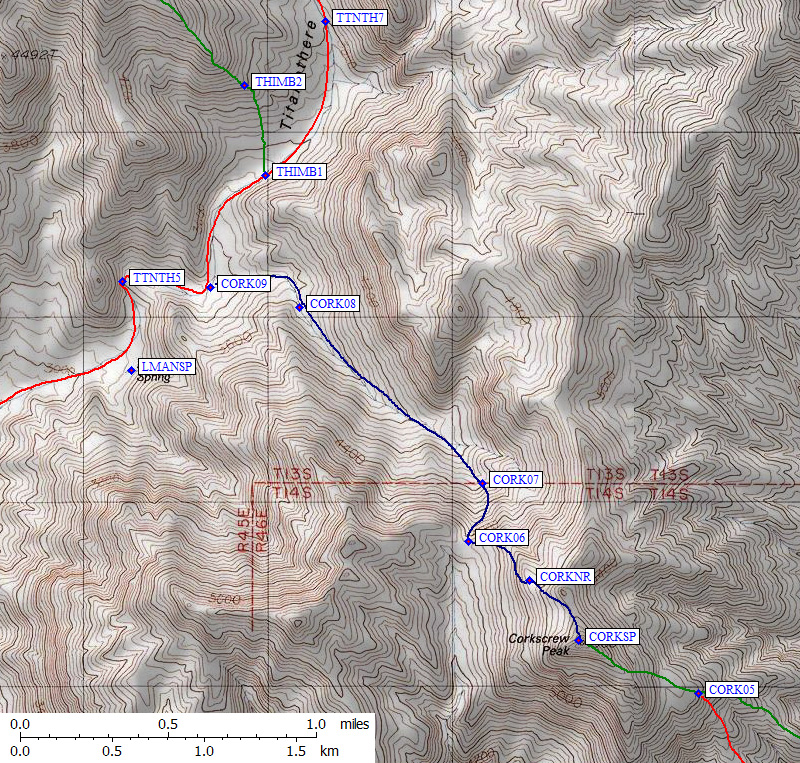
Corkscrew (south) Map - see overall map above for context