The general plan was to attempt the peaks that surround the Little Lakes basin. On the 21st I headed up the drainage past Mills Lake to attempt Mt. Mills. Weather- mostly clear. I had heard a lot about how others had either not enjoyed this climb, or had difficulty finding the correct chute to follow to the summit, or had troubles with the chockstone at the base of the chute, or a combination thereof. I brought along a photo of the chockstone which I later found to be very helpful.
Mt. Mills from the north ridge of Mt. Abbot
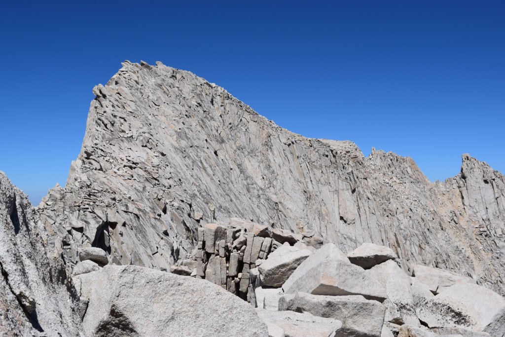
The climb up the drainage itself is very pleasant but heading up the loose scree slope to the base of the chute is tiring. Once at the base of the chockstone I found I couldn't quite make the last move up and over due to an overstuffed daypack so I rested here, ate lunch, and removed some of the bulk. The second try after lunch was successful with a slimmed down daypack.
Immediately above the chockstone the chute forks. I remembered someone saying the left fork leads up a narrow death alley full of large, loose rock although Secor's description has no mention of this intersection. Maybe in the next edition this should be noted. It would be very easy to go up the left chute by mistake and I'm sure many have.
Once past the chockstone, the right chute looked horribly loose, steep, and cruddy. In early season with a good snow cover, maybe it's ok. Just not now. Probably would have had to burn about 5000 more calories to reach the top from here and I may have turned back at this point had I not seen a large duck on the right marking the start of the Van Dalsem variation. I hadn't planned on going this way but it turned out to be the saving grace of the day. There is absolutely no doubt that this variation should be the standard route up the east face as opposed to the chute itself in snowless conditions.
As one meanders up the fairly decent class 3 rock that parallels the chute, one has continuous views down into the chute, constantly confirming they made the right choice by staying out of it. There were no route finding issues. Near the top, an obvious, wide ledge system leads south (left) to the summit plateau and the highpoint. The views from the summit were fantastic and I retraced the route on the descent.
There's always a certain satisfaction when one finds a way up something that looked unattainable or completely miserable somewhere along the way. And I think we all know that feeling at some point.
The climb up Mills took a physical toll and the following day was clear with wind gusts 40 mph plus so I decided to take a rest day. I lounged by the lake all day, socializing with Tim and his son Eric who were fishing the lake. Nice guys. I was hoping they could catch us all some dinner but the winds were causing too much turbulence for that to happen.
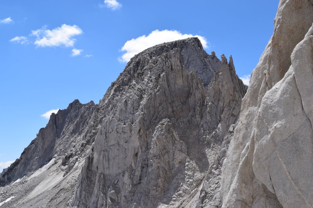
The following day, Aug.23, I retraced my footsteps further up the drainage to the base of the north couloir beneath Mt. Abbot. In this dry year the couloir was completely devoid of snow or ice. Starting up was ok, but it soon turned into muddy slush on a steepening slope. I thought it might be amusing to yell out "mud!!" when it started to sluff downwards 2-3 feet but somehow refrained from the frolic. Above the mud was a mix of dry sand on downsloping, rounded ledges which in turn led to a horribly steep, loose traverse across to the class 3 rock on the right (north) side of the couloir. It was here that I had to dig all 10 fingers into the loose sand like claws, not only to make headway, but to keep from losing ground and sliding. As with Mills, I decided that if the climbing does not improve once out of the couloir that I would not continue. It was actually beginning to feel dangerous at this point.
Once on the class 3 rock, the route began to gradually improve. The north ridge crest, the airy catwalk, and summit area were all spectacular. I looked all over for a summit register but found nothing. After an enjoyable hour on top I retraced my steps down to find a group of 10 or so climber's having difficulties traversing out of the couloir, still on their way up. One of the group was frozen in place and asking for a rope so I stopped in place above them and waited while the group tried to rig something up, not wanting to kick down any rock. After 20 minutes the climber was still unable to move on so I gingerly crossed over above them, entered the couloir, and descended back to Ruby Lake.
Mt. Abbot from the north
Aug. 24- Headed back down to Bishop for a shower and motel room. Got the permit for the next half of the outing.
Aug. 25- Drove back up to Mosquito Flats and backpacked up to Treasure Lakes where I made camp under mostly cloudy, calm skies. A lot of talus hopping between Long and Treasure lakes. Arrived in late afternoon. Made camp at the small N.W. lake, elevation 11,200 ft. approx.
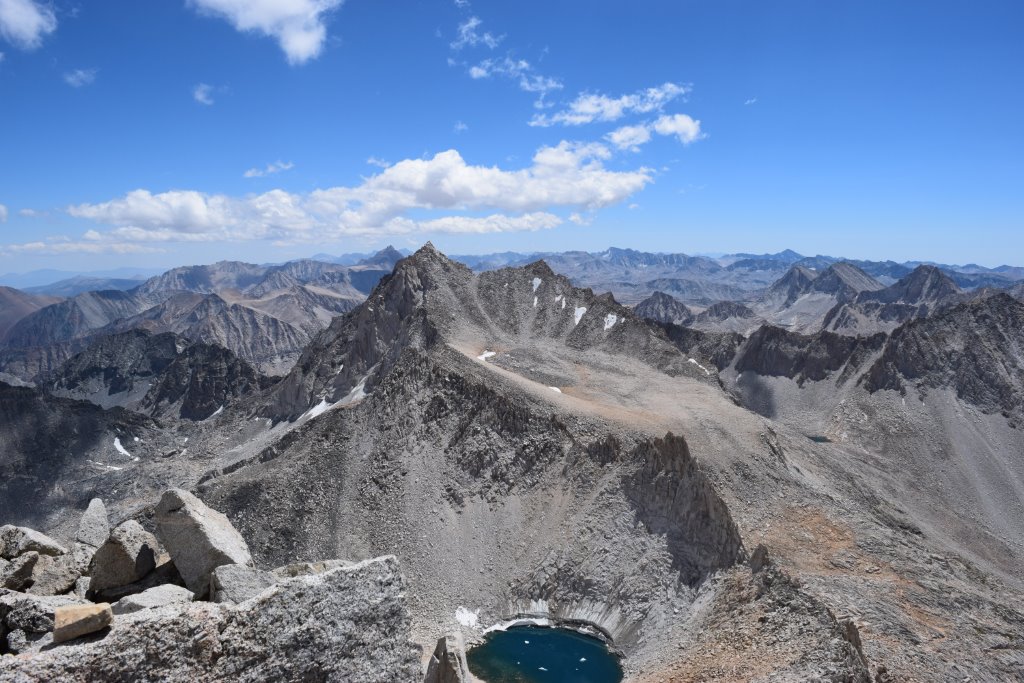
Aug. 26- Climbed Mt. Dade via a direct route from the N.W. lake, staying just right (west) of, and out of, the Hourglass couloir. First a lot of talus, then a lot of sand from the crest of the couloir all the way to the summit. A mediocre route at best, although the views of Bear Creek Spire and Mt. Abbot from the summit were outstanding under clear blue skies in all directions. I probably should have descended via the couloir but didn't.
Bear Creek Spire from Mt. Dade
Aug. 27- Bear Creek Spire. I wasn't too sure about Bear Creek Spire. I'd never done a climb this technical before. The east ridge of Mt. Russell, twice, Mt. LeConte, 3 times via the Waterfall pitch, Carl Heller, Mendel's east face, and Darwin were probably some of my toughest climbs to date. My only plan was to proceed as far as possible via the class 4 Ulrich route and maybe I had a 50-50 chance of success. I was ok with that. I brought along rock shoes but no climbing gear.
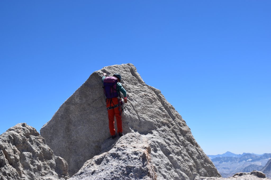
I started early. Probably about 6 AM. (I didn't have a watch on hand). The talus climb up to Dade Lake went well. As I traversed around the east side of the lake I was constantly staring up at the northeast ridge of Bear Creek Spire. Actually, it appeared quite doable to the headwall which supposedly requires 200 ft. of class 4 at the summit wall. I watched 2 climbers making their way up that route. I, instead, headed up the drainage, and then ascended the weak ridge towards North Col, as planned, avoiding Cox col as per Secor's recommendations. (He's right. This route is a cakewalk compared to Cox col.) Once over the col, the climb up the west side of the Sierra crest to the summit wall is class 2. I watched the 2 roped climbers above me traversing the base of the summit wall. (I thought they had already reached the summit and were heading down but that turned out to be incorrect. They hadn't attempted the summit yet.) Now, at the base of the wall, I put on the rock shoes. The roped climber's were now 40 feet below me, eating lunch as I started up the diagonal class 4 crack. This also went very well. Great handholds, knobs, sticky granite. Above the crack system, I continued along the horizontal ledge to the second left facing "easy" chimney. (The first chimney looked pretty rough and I declined it.) Once up the easy 5 ft. chimney, brings one to the spine of the summit ridge, maybe 40 ft. from the 5.6(?) summit block. I continued along the airy ridge towards the base of the summit block, stood on the lower perch at the base of the block, found a good hand hold, lifted my right foot onto the sticky west facing side, and pulled myself onto the summit block in a fairly doable fashion. I was now sitting atop the summit block. The climb was over.
Climber at the base of the summit block of Bear Creek Spire
I descended the block by reversing the same moves as it took to climb it and then sat on the summit ridge and had lunch while watching the 2 roped climbers ascend the wall. Steve and Cristen. We spoke awhile but they choose not to climb the summit block and then rapped down the summit wall on the descent. They had done this as a day hike from Mosquito Flats and were eager to get back to the car.
Afterwards, I descended the class 4 route exactly as I had climbed it. It left me just a little shaky and exhausted, although at no point did I feel overwhelmed by it. I would most certainly do it all again. Bear Creek Spire- thanks for the memories.