Overview Map (see below for west face details and interactive map link)
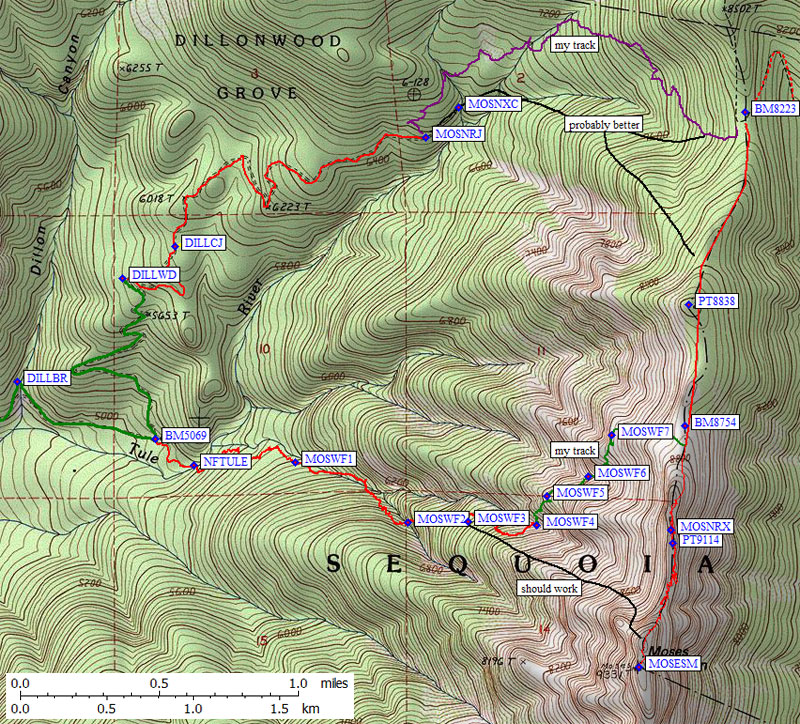
Without the benefit of Mike's 4WD this time, I had to leave my car in the parking area where the pavement ends (waypoint F19S09 on the Dillonwood trailhead page) and trudge up the road. At 8am it was already hot and the gnats were out in force. Long stretches of Dillonwood road are still paved, but most is reverting to rocks and dirt. You'll need high clearance from near the start, and given the deep ruts with steep sides it is no longer possible to reach the Sequoia entrance gate without a real 4WD.
The wooden bridge below Dillon Mill (waypoint DILLBR) is starting to rot, and even on foot it was disconcerting to go over boards that have fallen through. The only person I saw on this entire trip was a gold prospector who drove over the bridge while I was basking on the slabs and soaking my feet. Just after bridge I got my first view of the west face of Moses, which still had snow in late April on a dry year.
The North Fork Tule River makes a lot of noise in the spring. Hoping to find a good way to cross it where the canyon walls weren't too steep, I left the road near BM5069 by going straight where the road turns away from the river. The brush wasn't bad and I crossed at NFTULE on very slippery rocks to reach the even less brushy northwest slopes. I intended to follow the river but quickly abandoned that plan in favor of the dry duff under big trees which tended to minimize brush. The red line on my map is the track log recorded by my GPS. Some of the squiggles must be positional error, I can't have walked that un-straight of a line!
Lower West Face Map (see below for interactive map link)
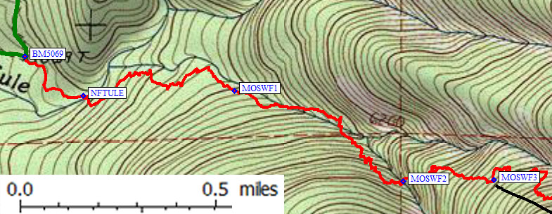
Around the 5.6k contour (waypoint MOSWF1) the terrain opened up a bit, switching from pines to leafy trees and very little brush. Seeking the best terrain for walking always pushed me to the south, away from my intended route. Oh well, so much for guessing where to draw a line on the map! The un-named stream to my left was running on slabs, with nice water slides but steep sides into the stream cut. I really wanted to walk on solid rock, but it was a mistake to scramble down into the streambed because I soon hit a mossy waterfall and had to climb back out around 5.9k.
I climbed very steeply in the trees until about 6.3k, where I forced a stream crossing (waypoint MOSWF2) because I didn't want to keep angling south. It was a marginal crossing due to brush on the other side, but the stream cut sides were the easiest in the area. All the ribs here climb to the southwest, but I wanted to go northwest so I kept trying to see where I could cross the next stream which also had steep cliffy sides.
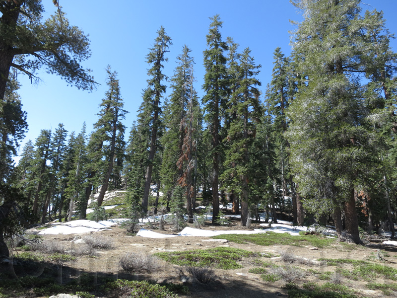
View above camp
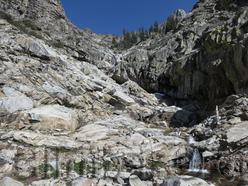
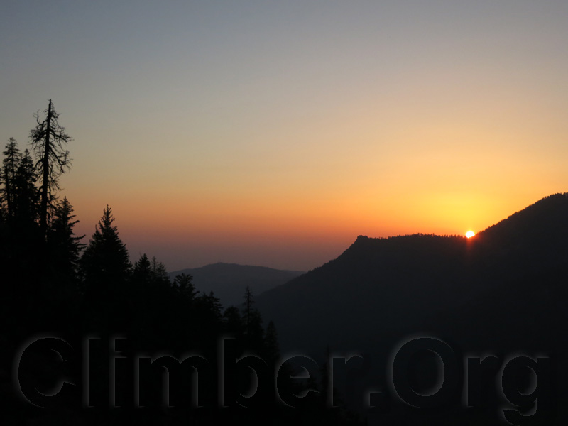
I found a reasonable ramp which angled down to a good campsite (waypoint MOSWF4), with only minor bushwhacking and a reasonably small drop. To find this place without a GPS, climb until the trees thin out and drop to the stream between two sets of cliffs. It took about 8 hours from the car to camp, so I had plenty of time to enjoy the babbling brook which cascades from pool to pool, take a dip, and enjoy the sunset.
Central Valley Sunset
Day hikers should NOT come down to where I camped! See the black line on the map below, starting at waypoint MOSWF3: Stay on the north side of the rib which rises directly to the peak, angling left into a bowl when the rib gets rocky. Exit the bowl by turning south behind a huge pinnacle and reach the bump just north of the peak from the saddle above the pinnacle. When I was there this bowl was a mix of boulders and snow, so bring an ice axe if you're climbing in the spring.
Upper West Face Map (see below for interactive map link)
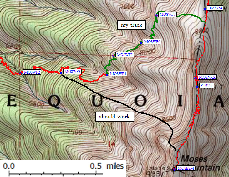
I was worried about hauling a full pack along the summit ridge, so I left what I assumed would be the last water and climbed north up through thick brush to the live tree left of the prominent large dead tree. It's tricky going here, with brush taller than me surrounding even larger boulders that are hard to scramble up with full pack. From the big tree I traversed level to the left below an outcropping. Once on rib north of my camp (waypoint MOSWF5) the footing improved (boulder hopping instead of brush) as I dropped slightly to cross one final tiny stream (waypoint MOSWF6). If anyone ever repeats this route, they should fill up on water here, if it's running, but there are no good places to camp.
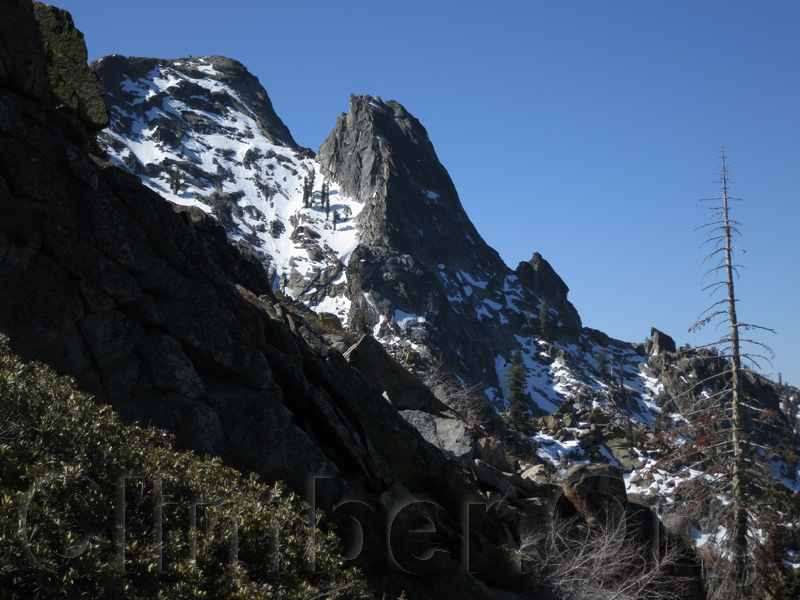
Moses and the Pinnacle
Easy terrain from that stream leads up slabs and talus. I left the stream and angled left below obviously bad brush to the ridge. Even more bad brush convinced me to traverse level (waypoint MOSWF7) to the north side of the rib, which is well worth the detour! It was boulders and then pine duff to the ridge, which I reached just south of BM8754, about 3 hours from camp. There were patches of snow and flat dry sand on the ridge, making this an excellent place to camp if you don't mind melting snow for water.
The easy part of the ridge!
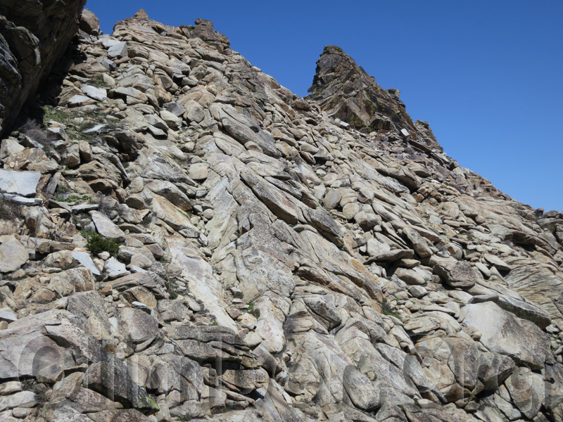
After a long break, I strolled south up the easy ridge which quickly becomes class 2-3. Gullies cut impossible gashes from the class 5 ridge hundreds of feet down to class 2 boulder fields choked with brush. Route finding was not obvious, but I built a few ducks and I figured my GPS track would bail me out on the way down. I always stayed east of the ridgeline, with very few exceptions where I was on the ridgetop, and while I didn't think the class 3 moves were horrible I was very glad I didn't have to deal with a full pack.
Finally, the summit of Moses
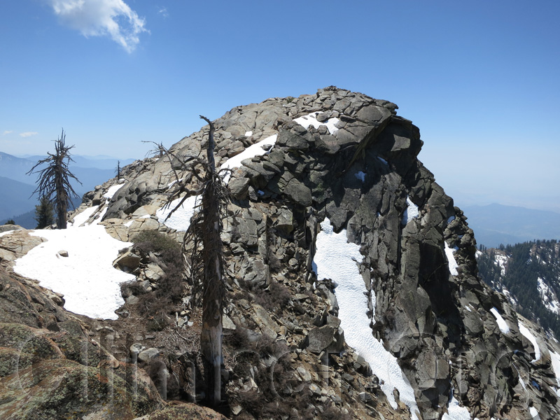
I reached the 9331' summit at 1pm and (as usual) spent an hour on top. Less than a mile away and 500 feet up from my pack, which had taken almost 3 hours to climb. Yuck! Either I've slowed way down or that was really hard to figure out. (By the way, my altimeter accumulated over 400' of gain going back down, so it's not just about the net gain when climbing.) I was the first to climb Moses this year, the previous climber was Matt Hengst in October 2012. He also took a non-standard approach, from the Summit Trailhead further east. Hey, if you're gonna climb bumps, you might as well make the approach interesting!
My GPS track was essentially useless on the way down, but generally route finding was no harder in that direction except near waypoint MOSNRX, 70 yards north of PT9114. There is a square saddle with a bright yellow lichen face to the south, near which I had to downclimb sharply 50-100' into a notch (which didn't look great) to reach a dirt patch on the other side and then climb back up. On the way out I couldn't find the route I took going up, even though the track log said I was on top of it. Perhaps the GPS made a mistake, maybe I didn't want to downclimb something I went up, but I hunted half an hour before finding a way around the pinnacle north of that square notch. I may have gone around the west side of it going up, but that didn't look good either on the way down.
I got back to my back to pack after 4pm, much slower than expected, and made the poor decision to pack on down the ridge to camp. There were no sites as good as the one I walked away from, with a view and flat sand and slabs, but lots of places in the trees and duff that were OK. I camped just above the saddle where the USGS map shows a trail crossing the ridge (waypoint BM8223). I slept in, waiting for the sun to hit my bivy before getting up, and enjoyed the warm morning knowing it would be hot at the car. (And it was, about 5 hours later.)
Easy walking below 9k
There is no trail I could find on either side of the ridge, there is no sign, and I should have left the ridge further south. I traversed northwest and occasionally caught a glimpse of a former trail, but it was totally not worth the effort since at this altitude the footing was all pine duff with no brush and I wished I had dropped straight down the drainage (from near PT8838, as shown by the northern black lines on the overview map above, marked "probably better"). The purple line (my track log) shows some major detours as I hunted in places the trail should be. At about 7k I crossed a stream and hit fairly bad brush... which is predictable in this area because it's a south-facing slope. I found old roads and trails so overgrown with large trees and brush that it was easier to walk elsewhere, but eventually I got on a dirt road which went south to the main 4WD road (waypoint MOSNRJ). If you take this route going up, stay right at MOSNRJ to avoid the nasty brush I found, and save me a waypoint where the road actually ends (near waypoint MOSNXC ?).
The road above the former Dillonwood trailhead (waypoint DILLWD) doesn't match the map, and there is a junction (waypoint DILLCJ) which isn't on the map. Going up, stay left (north) there unless you want to go explore the abandoned cabins. The trailhead sports a large bear box and a gate which (according to all the fresh tracks) is widely ignoed. The apparent "trail" visible beyond this gate on Google Earth is an active 4WD road, which the prospector told me was only used by bear hunters. I guess that's why I didn't see any sign of bears the entire trip, eh?
Datum,North America 1983,GRS 80,0,-1.6E-7,0,0,0
RouteName,1 ,MOSES WEST FACE
RoutePoint,D,BM5069, 36.2904499769,-118.7120800018,04/26/2013,18:45:50,MOSES WEST LEAVE RD NEAR BM
RoutePoint,D,NFTULE, 36.2890700102,-118.7095700502,05/18/2013,12:16:38,CROSS NORTH FORK TULE RIVER
RoutePoint,D,MOSWF1, 36.2892400026,-118.7030600309,04/26/2013,18:46:11,
RoutePoint,D,MOSWF2, 36.2860900164,-118.6957999468,04/26/2013,18:46:28,
RoutePoint,D,MOSWF3, 36.2861399651,-118.6919100285,05/19/2013,16:51:08,
RoutePoint,D,MOSWF4, 36.2859799862,-118.6874899864,04/27/2013,23:16:23,CAMPSITE GOOD WATER
RoutePoint,D,MOSWF5, 36.2874599695,-118.6868300438,05/19/2013,17:34:07,
RoutePoint,D,MOSWF6, 36.2884999514,-118.6841800213,05/19/2013,17:37:25,LAST TINY STREAM
RoutePoint,D,MOSWF7, 36.2906500101,-118.6826900244,05/19/2013,17:37:52,TRAVERSE BELOW BRUSH
RoutePoint,D,BM8754, 36.2911410332,-118.6779698133,05/19/2013,17:48:42,RIDGE NORTH OF MOSES
RoutePoint,D,MOSNRX, 36.2856999636,-118.6788799763,04/28/2013,18:19:04,HARDEST PLACE TO FIND ROUTE
RoutePoint,D,PT9114, 36.2850570679,-118.6787396669,04/26/2013,18:14:30,
RoutePoint,D,MOSESM, 36.2785600424,-118.6809400320,09/02/2005,14:31:54,2_5 MOSES MTN 9331
RouteName,2 ,MOSES NORTH RIDGE
RoutePoint,D,DILLWD, 36.2988400459,-118.7141400576,09/18/2004,22:56:46,DILLONWOOD ENTRANCE SEQUOIA
RoutePoint,D,DILLCJ, 36.3004900217,-118.7107800245,04/26/2013,18:45:24,JCT NEAR CABINS STAY LEFT
RoutePoint,D,MOSNRJ, 36.3061599731,-118.6946500540,04/26/2013,18:44:51,HIGHEST KNOWN JCT STAY RIGHT
RoutePoint,D,MOSNXC, 36.3077000380,-118.6925300360,04/29/2013,16:39:24,END OF OLD ROAD ON MAP
RoutePoint,D,BM8223, 36.3074599504,-118.6740900278,10/01/2004,18:37:11,MOSES TRAIL SADDLE 8223
RoutePoint,D,PT8838, 36.2974528074,-118.6777524948,04/26/2013,18:14:16,
RoutePoint,D,BM8754, 36.2911410332,-118.6779698133,05/19/2013,17:48:42,RIDGE NORTH OF MOSES
RoutePoint,D,MOSNRX, 36.2856999636,-118.6788799763,04/28/2013,18:19:04,HARDEST PLACE TO FIND ROUTE
RoutePoint,D,PT9114, 36.2850570679,-118.6787396669,04/26/2013,18:14:30,
RoutePoint,D,MOSESM, 36.2785600424,-118.6809400320,09/02/2005,14:31:54,2_5 MOSES MTN 9331