|
Several years ago I started wanting to get my last "hard" state high point. The "hard ones" list, according to one highpointer, is Denali,
Ranier, Hood, Borah, Gannett and Granite (maybe I'll write those other reports some day). Some consider Granite the hardest except Denali, others generally put it down as harder than Rainier, all because they don't know about the route(s) described below. It's really not bad once you get over all the guide book routes.
Everyone I know who has considered or done Granite says you have to approach from Froze to Death Plateau and there's a Class 4-5 section with a rap on the way down. I wanted to do it solo so I kept looking for another way. I found several reports on the so-called Southwest Couloir route buried in a blizzard of "I did it too!" and "I did it faster!" reports on the normal route and decided to go for it. See the bottom of this report for links to reports I actually found useful. Weather killed my solo trip in 2010, a bad back killed a group trip I was going to lead in 2011, and this year I signed up for an August group trip with consensus turmoil instead of a designated leader. After my Seattle-area glacier-climbing multi-peak trip fell apart in July, and it started raining in Portland, I realized I had more than enough supplies and gear for Granite. I had convinced the group to try the SWCol route, but there had been several suggestions to split the group and I didn't really feel included, so instead of going home and waiting for the group trip I pointed my car east and went back to my original plan of doing Granite solo. (Visualize one of those corny movie maps with a red line that crawls up the Columbia River, across Idaho, then through Bozeman and Yellowstone before bumping into a backcountry bistro.)
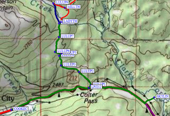
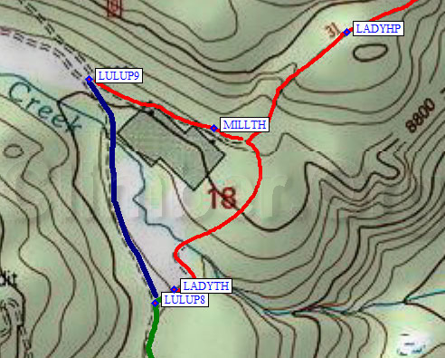
The road toward Lulu Pass (waypoints LULUP1-9) is an excellent dirt road, suitable for any vehicle. There are many unmarked side roads, just follow the obvious main one. It's only a 15 minute drive from the highway to the trailhead. The turn to the official Lady of the Lake trailhead (waypoint LADYTH, 8.7k) is NOT marked, and at night the trailhead sign is not visible from the main road. Turn right at waypoint LULUP8 and drive slightly downhill toward Fisher Creek. The trailhead sign and ample parking comes first; if you continue a bit further you'll find a nice campground in the trees. I didn't see any fee collection signs, but I didn't look very hard since I didn't see the trailhead until I was driving home.
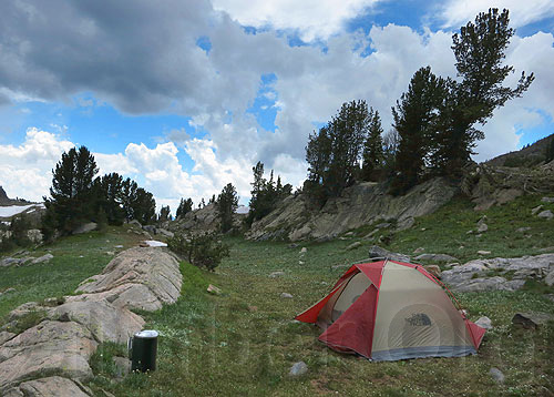
There are good campsites along the west side of the lake, but it's only 2 miles from the car. I spread my tent out to dry and took a break. It's worth mentioning that I had packed for a glacier trip with a group: I had my 5-pound 3-season tent, warm pad, 15 degree bag, 5 days of food, steel crampons and ice axe, snowshoes, etc. I was overprepared and I knew it, but I wasn't trying to set any speed records and that 60 pound pack meant I could sit out or climb through just about anything. The one thing I almost didn't take but was really glad to have? Five Fingers Vibram shoes for stream crossings!
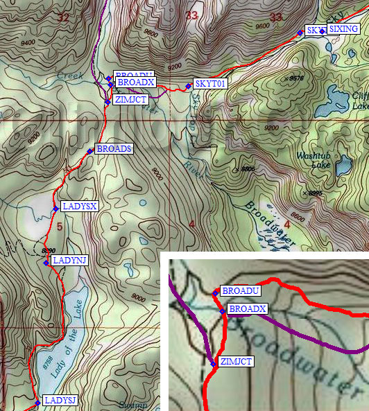
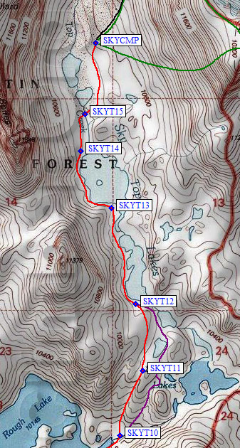
Descend about 150' along the north side of Broadwater, then follow the use trail as it cuts across to the much larger Sky Top River (waypoint SKYT01, half a mile from ZIMJCT). This is a scenic gorge with a good trail that tops out at an overlook (waypoint SKYT02, just over a mile from ZIMJCT) of your first tough stream crossing. Descend slightly to where the side stream from Aero Lake braids (waypoint SIXING) and start wading. This was the first crossing where my Five Fingers shoes really were great, because the water is fast and the rocks are slippery, and because there were 6 braids to cross! Perhaps later in the season this stream would be easier. Note that the braided stream is 100 yards from where the map shows a single stream, so we can assume there was a serious flood some time ago. Also note that the USGS uses both Aero and Areo, but I think it's really Aero Lake.
[It was pointed out to me in 2014 that not everyone knows 'duck' means the same thing as 'small cairn'... it's probably a regional term, but a big rock with a couple little ones on top of it can look a little like a duck if you're tired enough!] Feeling the altitude, knowing the weather would improve, and not being pushed by a group, I camped just after crossing the outlet of Shelter Lake (waypoint SKYT05) on a cool bench with good backrest rocks and a light breeze to keep the mosquitoes away. I had walked about 6.5 miles in 5 hours (not counting the rain shower). Rather leisurely! Others have camped at Lone Elk Lake (less than half a mile from where I camped) and done the peak from there, but I wanted to camp high and be off the peak before noon.
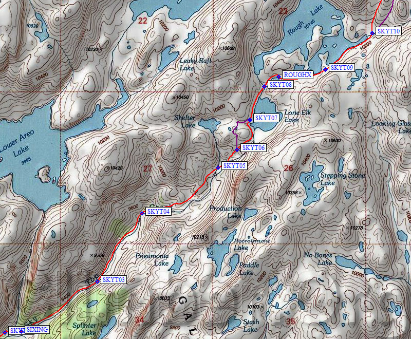
The use trail basically vanished at Lone Elk Lake (waypoints SKYT06-7), where there was some steep snow which might have covered it up. There were some ducks above that but I'm guessing lots of people come to Lone Elk lake or Rough Lake for fishing and camping. You can go around either side of the bump southwest of Lone Elk Lake, but stay west of the lake and cross the direct outlet of Rough Lake at waypoint SKYT08. There is a second (indirect) outlet of Rough Lake further east, and that's the really rough crossing (pun intended). On the way in I followed ducks to the outlet of the small lake which is only slightly detached from Rough Lake, and found a deep channel in the middle of a stream I had to wade. I stepped between two submerged boulders across the deepest part, in a strong current, but that was an unnecessary risk. On the way out I ignored the ducks and crossed at waypoint ROUGHX where the wading was simple. Hopping rocks might be possible later in the season, but they're slick and I'd still plan to wade.
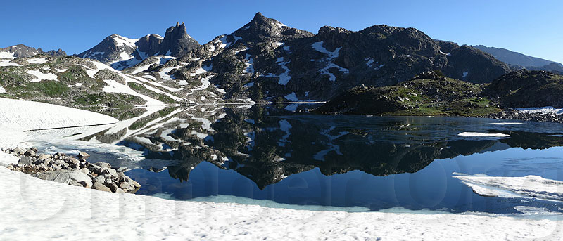
Rough Lake reflection Be sure to stay right (south) of all the water! It's easy to end up on the Rough Lake peninsula, which is worth a side trip just to look over the lake (see above) but not worth carrying a pack. Close to the Rough Lake inlet (waypoint SKYT10) the outlet of Sky Top Lakes is wide and tame, and I managed to cross it without getting my feet wet. There were large snow patches here (at 10.2k) and no trees. There are places to camp, but none as good as in the upper Sky Top drainage.
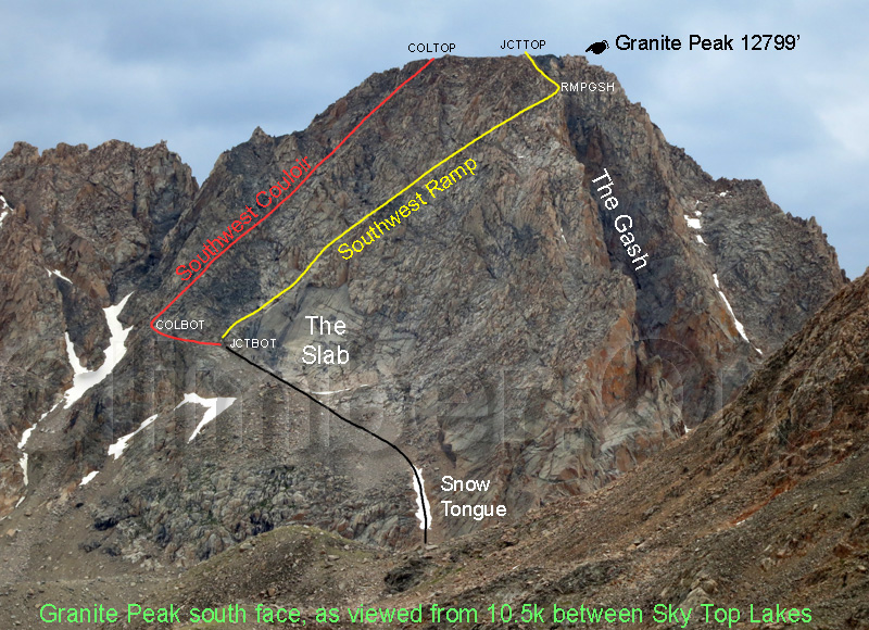
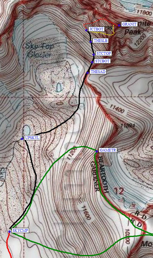
I left camp around 6am, walking mostly on snow all the way from the lakes. Later in the year boulders and moraine may mean another route is better. The highest Sky Top Lake (waypoint UPSKYL at 10.8k) is fed by a spring coming out of the moraine, and is the highest reliable place to get water. From there I angled over to The Saddle south of Granite (waypoint THESAD). Above The Saddle, there are huge boulders, an unstable talus field, a chute which often has a Snow Tongue, a more stable talus field, and finally The Slab which marks the start of both routes described below: the Southwest Couloir and the Southwest Ramp. (I made up the "Ramp" name to reduce confusion, since the report links below describe two completely different routes but call it the same thing. I went up one of them and came down the other.)
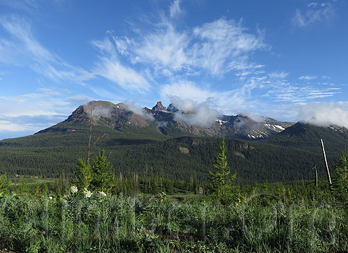
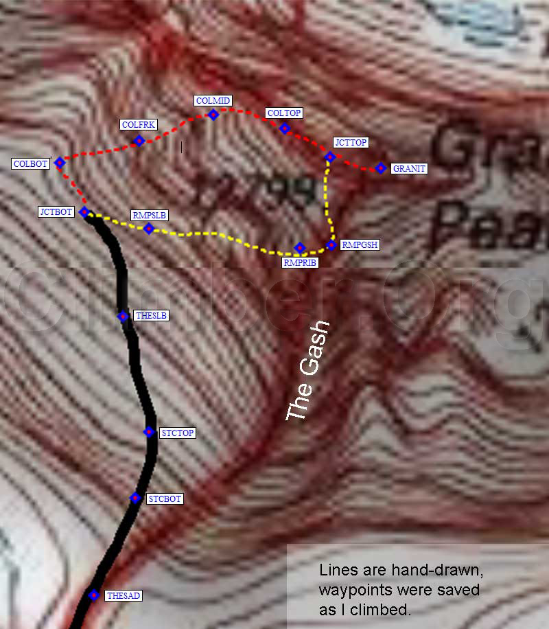
Refer to the picture above for the south face of Granite. This was taken from the inlet of highest Sky Top Lake, a good place to get your bearings. I also took sunlit pictures, but the high contrast obscures some of the important features so I'm publishing this rather ugly but utilitarian image instead. The lines are about right, but only intended to give you a feel for where you'll be on the face. Use the GPS waypoints and descriptions below to follow the routes described, or check out the interactive map for a 3D view of the actual waypoints in Google Earth. The Southwest Ramp turns left at the edge of The Gash (RMPGSH), and tops out just left of the black patch on summit ridge (JCTTOP). The Southwest Couloir hits the summit ridge (COLTOP) west of the Ramp route, but it's an easy scramble to the summit. The high point is the light patch on the extreme right of summit ridge, maybe not where you'd expect it! About "The Gash" (a name I made up just for convenient reference): On the USGS map (below) there is a Beartooth-Gardiner boundary line that follows the south ridge of Granite Peak and encircles the Sky Top Glacier. That line forms the west edge of The Gash, a deep chute that runs from top to bottom on Granite's south side. It often shows as a shadow on the right side of summit photos. It's more prominent when viewed from Cairn Mtn. The upper west side of The Gash is a rib that forms the upper portion of the Southwest Ramp route, where splattski's report mentions looking across a "yawning abyss" to the summit face. You will never get that view from the actual Southwest Couloir route!
Below you will find an extremely enlarged details map and descriptions of both routes, since I descended the easy route after climbing the hard one. Hopefully these two descriptions will help future climbers find and stay on whichever route they choose! Note that each route follows a defect that's visible in the topo lines if you zoom in far enough. See below for an interactive map link, with which you can overlay these waypoints on satellite images in Google Earth!
The Real Southwest Couloir:
|
|
The high point is at the far east end of the summit ridge, a light colored patch of rock to the east of a dark patch. When viewed from the Sky Top drainage, these color variations should help you believe it's really that far over (and make you wonder if the lines on those photos are correct). There were several ducks along the ridge, either marking the way to the summit or marking where other routes reach the ridge. Several entries in the summit register indicate people found this route harder than they expected, probably because there are two completely different routes which are called the same thing.
I reached the summit (waypoint GRANIT) at 1030am. My altimeter read 500' low all day (I seldom calibrate), but surprisingly my GPS said only 12060' on top. That's a huge error from the 12799' shown on the map and it makes me wonder if the map elevations are accurate in this area. |
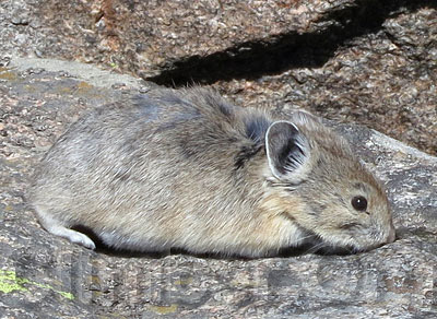
I had the top to myself until a pika showed up in search of salt. I soaked up the sun for a long time, took dozens of pictures, and updated Stella via sat phone. Finally my thoughts turned to the descent, and I peered over various edges trying to decide if there was a viable alternative to my ascent route. I know, I know, it's bad to descend a different way than you climbed, but the wind had stopped and the clouds had cleared and it was still before noon. I had 10 hours of daylight left, plenty of time to climb back up and go the other way if I cliffed out. Also, because of my relaxed approach and warm-up climb of Cairn, I was not feeling the altitude as I often do.
I found ducks leading down onto the rib at the edge of The Gash, which is closer to the summit than where I hit the ridge, and decided I'd give it a go. This turned out to be far easier than the Real SW Col, more of a broad chute and/or a ramp than a couloir... so I'm calling it the Southwest Ramp! (See below for more notes on this distinction.)
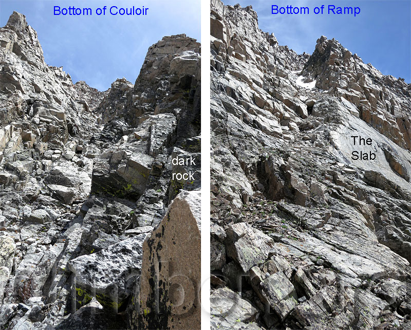
When climbing, turn up at big piles of rocks IMMEDIATELY after you pass under The Slab. I found ducks in three directions from this point, but NOT in the direction of the easy route. Strange. The defect under the slab levels and continues into darker rock for the SW Col, but you want to look up right at the left (west) edge of The Slab (waypoint JCTBOT, just below 12k) for the SW Ramp. From here the base of the SW Ramp does NOT look like a chute at all, much less a couloir, which confused me and convinced me to keep traversing! Go up the ramp formed by the left upper edge of The Slab, as pictured above. You'll end up in a broad chute which gradually narrows above The Slab. Waypoint RMPSLB is about where I got off the solid rock of The Slab and into rubble, below the snow in the picture above.
This wide rubble-filled chute soon narrows, where I found ice (visible in the picture above) still hard enough to require crampons and an ice axe but not as steep as the SW Col. The narrowest section (around 12.3k) features polished bedrock, probably from continual rockfall. Someone left a piton here long ago, so there's at least one rap anchor if you trust it! This bit would be tricky if wet or icy. WARNING: Just above the polished rock section, a rock I dislodged in spite of my best efforts bounded all the way down the face of the slab at high speed. Take those reports about low risk of rockfall with a grain of rock salt. Shortly after I was there, one group kicked rocks on another and a helicopter rescue resulted.
The polished narrow section is the hardest part, and I did some of it with crampons so I'm not sure what it's like when completely melted out. Get through that and you're back in unstable talus and boulders. The bad news is that they move. The good news is that they don't move very far because it's not that steep. Drift right in this chute, choosing the easiest terrain, until you end up on the rib (waypoint RMPRIB, 12.5k) which forms its right (southeast) edge. There was a pile of rocks at this crossing and more ducks above it, but no ducks below it (perhaps due to avalanches wiping the chutes clean every winter). Take note of this rib crossing for your return, because going further down the upper chute will cliff you out!
Once across the rib, you are near the upper end of another broad chute. Portions of both chutes are visible from the summit ridge, which means you've been looking at the summit for a while now without really knowing it. Traverse right onto the improbably easy edge of The Gash which also forms the right (east) edge of this upper chute, less than 50 yards from the rib crossing. From here (waypoint RMPGSH) you can look across The Gash to the dark summit face. Once you see this black summit face it's time to traverse left. Follow the edge of The Gash or traverse on the west side. Continue north until you reach the main summit ridge before turning right (east), and following the summit ridge over a patch of black rock to the light-rock summit.
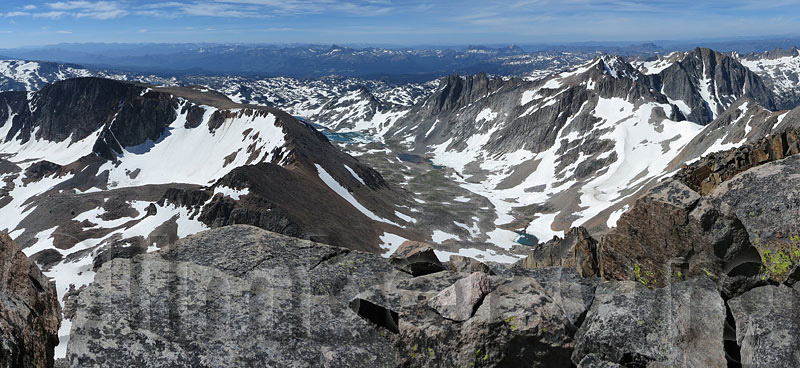
Looking south from Granite, down the Sky Top drainage
I got back to camp at 230pm after spending half an hour on the summit and wasting time finding routes in both directions. Now that I know the easy route (SW Ramp) and assuming no crampon use, I could easily shave a couple hours off my 6-hour climb.
|
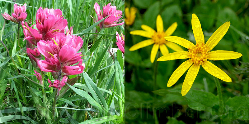
Rather than hiking down into bug and bear territory, I relaxed all afternoon, taking a dip in the lake, reading, napping, and thinking about climbing Mt Villard the next day. Almost no mosquitoes, a very gentle breeze, warm temps, a few early morning and late afternoon clouds drifting by, wildflowers, ground-nesting birds guarding unseen offspring, water cascading off The Spires... it was a very idyllic setting that I was loathe to leave. I'm sure things would have been different had I been with a group.
That was summit day. A perfect day. The next morning I awoke to rain on the tent before first light and ditched my vague plan to bag Villard. The rain let up long enough for the tent to dry while I packed and had breakfast, then a light drizzle started under really threatening skies as I started the hike out at 630am. |
Just before noon I parked my pack under a tree and ate lunch hoping the rain would stop. It did! Then it was hot and there were more mosquitoes. It took 9 hours to hike all the way back to my car from Upper Sky Top, including several long breaks. I met only 3 people on the way out, none at all on the way in.
Got spare time? Want some effortless sightseeing? Beartooth Highway (from Cooke City to Red Lodge) goes over a very scenic 10.5k pass with amazing drop-offs and alpine scenery. Unfortunately, the parking areas tend to be away from the greatest views, so people slow down and gawk instead of pulling off.
Datum,North America 1983,GRS 80,0,-1.6E-7,0,0,0
RN,1 ,LOWER SKY TOP
RP,D,ZIMJCT, 45.0864299536,-109.8859900236,07/20/2012,19:25:58,ZIMMER CK TRAIL JCT
RP,D,BROADX, 45.0876799822,-109.8856999874,07/20/2012,19:12:38,BROADWATER CK XING
RP,D,BROADU, 45.0880999565,-109.8859200478,08/25/2010,05:43:44,USE TR N OF BROADWATER
RP,D,SKYT01, 45.0875699520,-109.8780299425,07/20/2012,18:44:03,ENTER SKYTOP RAVINE
RP,D,SKYT02, 45.0913399458,-109.8668899536,08/25/2010,05:44:22,OVERLOOK
RP,D,SIXING, 45.0914299488,-109.8647500277,07/17/2012,18:07:59,SIX BRAIDS AERO XING
RP,D,SKYT03, 45.0961577892,-109.8545031548,08/25/2010,05:44:45,
RP,D,SKYT04, 45.1026577950,-109.8485442400,08/25/2010,05:45:04,
RP,D,SKYT05, 45.1070220470,-109.8383373022,08/25/2010,05:45:09,
RP,D,SKYT06, 45.1087533236,-109.8357963562,08/25/2010,05:45:29,
RP,D,SKYT07, 45.1115651131,-109.8340332508,08/25/2010,05:45:39,
RP,D,SKYT08, 45.1147269011,-109.8320939541,08/25/2010,05:45:48,
RP,D,ROUGHX, 45.1155188084,-109.8301094770,07/20/2012,15:45:08,ROUGH LK XING
RN,2 ,UPPER SKY TOP
RP,D,ROUGHX, 45.1155188084,-109.8301094770,07/20/2012,15:45:08,ROUGH LK XING
RP,D,SKYT09, 45.1163783073,-109.8239213228,08/25/2010,05:45:56,
RP,D,SKYT10, 45.1198163033,-109.8176640272,08/25/2010,05:46:09,
RP,D,SKYT11, 45.1242734194,-109.8154687881,08/25/2010,05:46:24,
RP,D,SKYT12, 45.1288655996,-109.8161602020,08/25/2010,05:46:47,
RP,D,SKYT13, 45.1354714632,-109.8185110092,08/25/2010,05:46:52,
RP,D,SKYT14, 45.1393514872,-109.8214668036,08/25/2010,05:47:02,
RP,D,SKYT15, 45.1419199705,-109.8210500479,07/20/2012,13:23:57,BEST SKY TOP XING
RP,D,SKYCMP, 45.1468100548,-109.8199700117,07/19/2012,01:00:16,GREAT HIGH CAMP 10600
RP,D,CAIRNM, 45.1464999914,-109.8001600504,07/18/2012,21:28:21,CAIRN MTN 12200
RP,D,GAMETR, 45.1532800198,-109.8100500107,07/18/2012,22:08:59,GAME TRAIL BELOW
RN,3 ,GRANITE PK MONTANA
RP,D,SKYCMP, 45.1468100548,-109.8199700117,07/19/2012,01:00:16,GREAT HIGH CAMP 10600
RP,D,UPSKYL, 45.1542700529,-109.8185700178,07/19/2012,12:42:40,HIGHEST SKY TOP LAKE
RP,D,THESAD, 45.1595742702,-109.8111128807,07/19/2012,13:20:11,THE SADDLE 11300
RP,D,STCBOT, 45.1604399681,-109.8105800152,07/19/2012,13:43:18,SNOW TONGUE CHUTE BOTTOM
RP,D,STCTOP, 45.1610300541,-109.8104200363,07/19/2012,14:06:56,SNOW TONGUE CHUTE TOP
RP,D,THESLB, 45.1620600224,-109.8107399940,07/19/2012,14:22:57,THE SLAB FACE 11800
RP,D,JCTBOT, 45.1629999876,-109.8112299442,07/19/2012,18:53:29,ROUTE JCT BESIDE SLAB
RP,D,COLBOT, 45.1634399891,-109.8115299940,07/19/2012,14:41:40,BOTTOM OF SW COL
RP,D,COLFRK, 45.1636300087,-109.8105399609,07/19/2012,15:07:48,FORK TO CLIMBERS RIGHT
RP,D,COLMID, 45.1638599634,-109.8095999956,07/19/2012,16:01:12,BETWEEN ICE PATCHES
RP,D,COLTOP, 45.1637400389,-109.8086999655,07/19/2012,16:23:07,SW COL JCT SUMMIT RIDGE
RP,D,JCTTOP, 45.1634911299,-109.8081398010,07/19/2012,17:24:25,ROUTE JCT ON RIDGE
RP,D,GRANIT, 45.1633929014,-109.8075002432,08/25/2010,05:19:12,GRANITE PK 12799
RP,D,JCTTOP, 45.1634911299,-109.8081398010,07/19/2012,17:24:25,ROUTE JCT ON RIDGE
RP,D,RMPGSH, 45.1627000570,-109.8081200123,07/19/2012,17:43:10,EDGE OF THE GASH
RP,D,RMPRIB, 45.1626700163,-109.8085099459,07/19/2012,17:48:57,CROSS RIB BETWEEN CHUTES
RP,D,RMPSLB, 45.1628500223,-109.8104100227,07/19/2012,18:45:56,TOP OF SLAB
RP,D,JCTBOT, 45.1629999876,-109.8112299442,07/19/2012,18:53:29,ROUTE JCT BESIDE SLAB
RN,4 ,LADY OF THE LAKE TR
RP,D,LADYTH, 45.0462800264,-109.9117900133,08/05/2012,17:29:34,LADY OF THE LAKE TH 8700
RP,D,MILLTH, 45.0506199598,-109.9102799892,07/17/2012,13:49:29,STAMPING MILL CABIN TH 8800
RP,D,LADYHP, 45.0532300472,-109.9052000046,08/25/2010,05:31:21,HIGH POINT BEFORE LAKE
RP,D,LADYSJ, 45.0652400255,-109.8929699659,08/25/2010,05:31:48,TRAIL JCT SOUTH OF LAKE
RP,D,LADYNJ, 45.0750900507,-109.8921200037,07/17/2012,15:20:54,TR JCT N OF LAKE
RP,D,LADYSX, 45.0789300203,-109.8911999464,08/25/2010,05:33:13,INLET STREAM CROSSING
RP,D,BROADS, 45.0829499960,-109.8877899647,08/25/2010,05:34:28,SADDLE BEFORE BROADWATER
RP,D,ZIMJCT, 45.0864299536,-109.8859900236,07/20/2012,19:25:58,ZIMMER CK TRAIL JCT
RN,5 ,LULU PASS ROAD
RP,D,SKYLIN, 45.0235999823,-109.8722399473,08/05/2012,17:29:34,SKYLINE GUEST RANCH
RP,D,COOKEC, 45.0199199915,-109.9328999519,07/16/2012,16:39:23,COOKE CITY
RP,D,LPJ212, 45.0264699459,-109.8999799490,07/16/2012,16:42:20,HWY 212 JCT LULU PASS
RP,D,LULUP1, 45.0272699594,-109.8991600275,08/25/2010,06:06:30,
RP,D,LULUP2, 45.0312600136,-109.9042199850,08/25/2010,06:06:38,
RP,D,LULUP3, 45.0332299471,-109.9118399620,08/25/2010,06:06:54,
RP,D,LULUP4, 45.0361100435,-109.9126000404,08/25/2010,06:07:04,
RP,D,LULUP5, 45.0368100405,-109.9115200043,08/25/2010,06:07:10,
RP,D,LULUP6, 45.0373100042,-109.9143199921,08/25/2010,06:07:15,
RP,D,LULUP7, 45.0418100357,-109.9126399755,08/25/2010,06:07:24,
RP,D,LULUP8, 45.0459100008,-109.9125299454,08/25/2010,06:07:35,LADY OF THE LAKE TH JCT
RP,D,LULUP9, 45.0519499779,-109.9150300026,08/25/2010,06:05:46,OLD MILL TH JCT
2004 (updated 2011)
Southwest Couloir route by Larry V
on SummitPost.org
This describes the easy route I'm calling the Southwest Ramp.
It has a picture with a route line drawn in, which may have been duplicated from splattski.com.
(That line doesn't seem to match my waypoints.)
2007
report on splattski.com
This describes the easy route I'm calling the Southwest Ramp.
It has a picture with a route line drawn in, which may have been duplicated on Larry V's SummitPost route.
(That line doesn't seem to match my waypoints.)
2009
Laser Strike report by Moogie737
on SummitPost.org
I thought this report describes the harder route I'm calling the Southwest Couloir... but Braden wrote me a note saying "I guess the
only evidence I see in that report of reaching the SW Couloir is that they
'passed below the slab and beyond the section which was blackened with
seepage stains.' Is that why you think they did the Couloir route? I
wonder if they meant the darker part of the slab and then went right above
it into the Ramp.", which made me think again!