|
The first time I tried this route was on 13 Mar 2004 with
Pat and Stephane.
I broke my leg (the first broken bone ever), I got locked out of my car (onboard computer failure), and everyone else got the peak.
The second time I tried this route was immediately after a big storm, on 24 Feb 2007, with Tim and Tony. All we did was grind half a mile through powder and spend the night before driving home. Neither snowshoes nor backcountry skis could really keep our knees above the surface, and we all realized instantly that we could never do the mileage through this kind of powder. Another vehicle parked at the trailhead was totally covered in fresh snow, with the only clue being a mirror sticking out a bit. |
Tony and Tim and someone else's snowed-in car: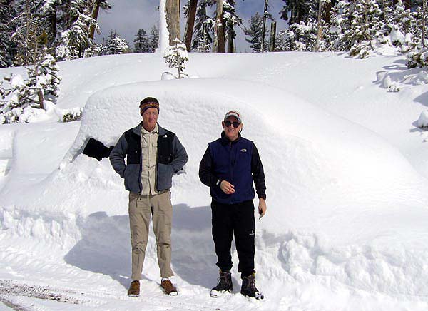
|
|
Later that spring, Chris and I gave it a go mid-week in keeping with my philosophy that you never 'conquer' a mountain. You try to sneak up while it's not paying attention, say 'hi', and hope the weather pixies leave you alone. This time worked like a charm!
|
On Squaw Ridge, Mokelumne is behind Steve: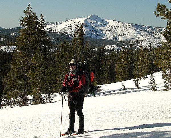
|
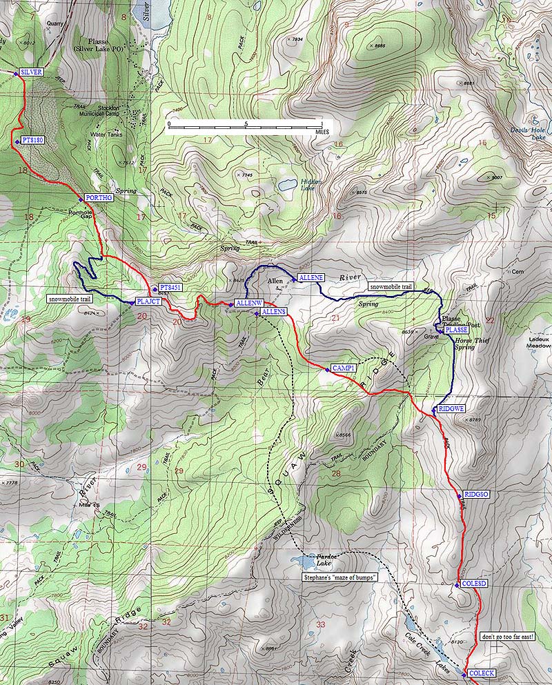
Here's the route map, scroll down for a description of the climb and GPS waypoints.
| |
|
We left the
Silver Lake trailhead
in the afternoon, planning to hike only part way in. We wanted a more relaxed pace than on Pat's trip (two long days back-to-back) because we wanted to make sure I didn't have to try yet again. We walked south up the snowmobile road to Porthole Gap (waypoint PORTHG) then went directly up the ridge to Point 8451. Again on the packed snow we walked the ridge to waypoint ALLENW where we cut cross-country down into the valley to find a campsite instead of staying on the road to Plasse Trading Post. We rounded a wooded corner and made camp next to a meadow with running water (waypoint CAMP1) and a bare rock to lean against.
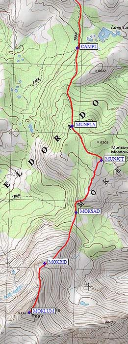
The next morning we packed up early and went over Squaw Ridge north of Point 8566. Either saddle will do. We went one too far north in the morning and came back on the red line shown below. Stephane's report indicates they took two routes here, and I've tried to trace their 'maze of bumps' route as a black dotted line... I would have gone that way except for his report, and I hope my report helps refine the optimal route even more. Somewhere near waypoint RIDGWE we traversed level until we came out on the shoulder at RIDGSO. This is a great place for lunch, and we soaked up the sun in a cozy tree well. Spring conditions at their finest. No more tracks. We stayed mostly on the ridge, occasionally sidehilling on the east to avoid bumps, down to the drainage from Cole Creek Lakes. Our second camp (waypoint CAMP2) was at the low point of the entire trip - yes, it's net downhill from the car to here - at the broad saddle near Long Lake and just north of where two trails cross. We had running water here also, even though the map doesn't show a stream. Arriving mid-afternoon, we debated whether we could bag the peak before dark. What the heck, eh? We had headlamps and GPSs and it would be all downhill if we had to turn back. We followed the route of the trail, even though we couldn't see it under all the snow, all the way to a significant saddle (waypoint MOKSAD). OK, it wouldn't be ALL downhill on the way out. The ridge immediately north of this saddle was mostly melted out, and we had to detour a bit to the west around brush and rock. Still, nothing hard until we reached the final pitch on the summit ridge. |
|
|
From waypoint MOKRID to the summit (waypoint MOKLUM), the angle gets fairly high. The mushy afternoon snow turned to patchy crust as we had to get off the rocky/icy ridge and traverse on the eastern (now shady) slope. The final 200-300' turned into a drifted knife edge and Chris decided he'd save that sort of climbing until he'd done a bit more practice. I charged off to the top, made a phone call, and half-plunge-stepped half-glissaded back down the knife edge. We split up at times on the way back down to the flats. I kept trying to get in a good glissade (but never did), while Chris concentrated on lower-angle stuff where he could keep marching. We ended up doing about the same pace but he put in a lot less work.
We got back to camp before dark, turned in early, and got a very early start the next day to avoid most of the slush on the way out. It worked! We were back at the car mid-afternoon and back in the Bay Area for dinner. A classic spring climb and this time nothing at all went wrong. |
Steve on his way to the summit of Mokelumne: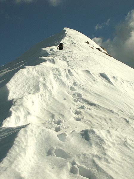
|
![]() Download the Waypoint+ data below as a GPX file for your GPS.
Download the Waypoint+ data below as a GPX file for your GPS.
Datum,North America 1983,GRS 80,0,-1.6E-7,0,0,0
RouteName,1 ,SNOWMOBILE RD
RoutePoint,D,SILVER, 38.6374700069,-120.1422799826,03/09/2004,15:34:42,HWY 88 NEAR SILVER LK 7900
RoutePoint,D,PT8180, 38.6310237646,-120.1421499252,02/23/2007,06:35:45,POINT 8180
RoutePoint,D,PORTHG, 38.6255500317,-120.1344499588,03/09/2004,15:34:56,JCT NEAR PORTHOLE GAP 7900
RoutePoint,D,PLAJCT, 38.6157500744,-120.1282939911,02/23/2007,06:36:51,JCT NEAR PLASSE PT 8400
RoutePoint,D,ALLENW, 38.6155999899,-120.1163699627,03/09/2004,15:35:41,JCT W OF ALLEN
RoutePoint,D,ALLENS, 38.6147700548,-120.1132600307,02/23/2007,06:39:16,JCT S OF ALLEN
RoutePoint,D,ALLENE, 38.6179875135,-120.1087546349,02/23/2007,06:39:56,JCT E OF ALLEN
RoutePoint,D,PLASSE, 38.6130553484,-120.0911028385,03/09/2004,15:36:43,PLASSE JCT 8600
RouteName,2 ,WINTER CLIMB
RoutePoint,D,SILVER, 38.6374700069,-120.1422799826,03/09/2004,15:34:42,HWY 88 NEAR SILVER LK 7900
RoutePoint,D,PT8180, 38.6310237646,-120.1421499252,02/23/2007,06:35:45,POINT 8180
RoutePoint,D,PORTHG, 38.6255500317,-120.1344499588,03/09/2004,15:34:56,JCT NEAR PORTHOLE GAP 7900
RoutePoint,D,PLAJCT, 38.6157500744,-120.1282939911,02/23/2007,06:36:51,JCT NEAR PLASSE PT 8400
RoutePoint,D,PT8451, 38.6170239449,-120.1255352497,03/09/2004,15:35:28,PLASSE POINT 8451
RoutePoint,D,ALLENW, 38.6155999899,-120.1163699627,03/09/2004,15:35:41,JCT W OF ALLEN
RoutePoint,D,ALLENS, 38.6147700548,-120.1132600307,02/23/2007,06:39:16,JCT S OF ALLEN
RoutePoint,D,CAMP1, 38.6094167233,-120.1047166586,05/11/2007,16:09:13,RUNNING WATER IN WINTER
RoutePoint,D,RIDGWE, 38.6055427790,-120.0919117928,02/23/2007,06:25:48,WEST RIDGE TRAIL 8500
RoutePoint,D,RIDGSO, 38.5974700451,-120.0887800455,03/09/2004,15:37:07,SOUTH RIDGE TRAIL 8400
RoutePoint,D,COLESD, 38.5889799595,-120.0890899897,03/09/2004,15:39:05,SADDLE NEAR JCT AT 8200
RoutePoint,D,COLECK, 38.5804699659,-120.0882400274,03/09/2004,15:39:32,COLE CREEK 8000
RoutePoint,D,CAMP2, 38.5732166767,-120.0862499475,02/23/2007,06:23:35,JCT AT LOWEST SPOT 7800
RoutePoint,D,MUNPLA, 38.5628199577,-120.0870800018,03/09/2004,15:40:03,MUNSON PLATEAU 8200
RoutePoint,D,MUNJCT, 38.5582799911,-120.0821199417,03/09/2004,15:40:22,MUNSON MDW JCT 8200
RoutePoint,D,MOKSAD, 38.5513399839,-120.0864200592,03/09/2004,15:41:59,LAST SADDLE 8200
RoutePoint,D,MOKRID, 38.5445929766,-120.0918080807,02/23/2007,06:22:25,RIDGE AT 8600
RoutePoint,D,MOKLUM, 38.5381100178,-120.0944199562,03/09/2004,15:42:10,MOKELUMNE PK 9334