We started at the Onion Valley trailhead at 7:45 am, hiking over Kearsarge Pass, and then on towards Glen Pass. Some of us were quite miffed to find the east side of Kearsarge Pass had been re-designed by a trail crew within the last 3 months. The original trail on the east side of Kearsarge Pass was rather steep, the new trail has several more switchbacks to lessen the steepness. Our displeasure with the new trail was that the steepness was lessened so much (for the horses?) that it felt flat, sometimes actually going back uphill in the downhill direction, resulting in needless extra walking.
Rather than go over Glen Pass to get to 60 Lake Basin, where we planned set up camp for both peaks, Steve was campaigning to try a short-cut to the peaks that avoided going over Glen Pass. Steve has suggested short-cuts before...some worked well, some did not, and others we blew off when we actually saw the ugly terrain involved. My first thought was it looked possible on the map, and could shave considerable time off our approach route, but we needed to see what the terrain is like when we got close.
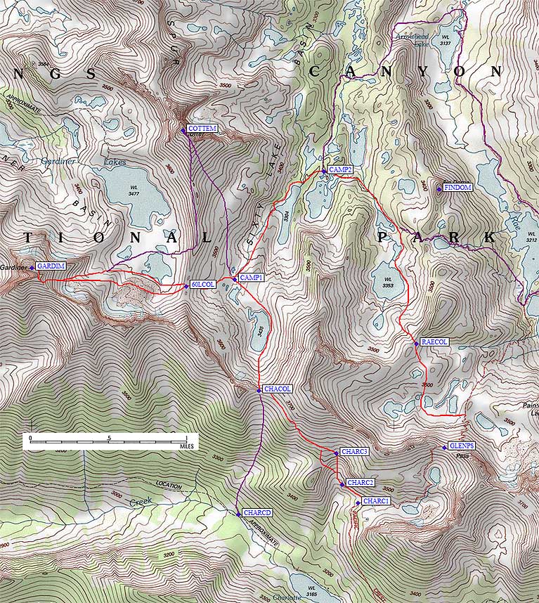
This short-cut called for us to leave the Glen Pass trail just as it turned east towards the pass, at about the 3360 m contour line on the 7.5 min map (waypoint CHARC1). Heading NW, drop into a bowl (waypoint CHARC2) and climb up out of the other side (waypoint CHARC3), then side-hill for about 2/3 of a mile continuing NW to an unnamed pass at 3640+ m (waypoint CHACOL). (See map and waypoints below.)
When we got to the designated jump-off point of the trail, the terrain for this short-cut really did not look too bad, at least the part we could see. Considering it already took us about 6 hours to get this far, there was little hope of reaching even the base of Mt. Cotter via the Glen Pass trail. The short-cut appeared to shave off some elevation gain and a few miles. It was unanimous; we would try the short-cut. The first part, dropping into and climbing out of the bowl, went fast. We then side-hilled to the unnamed pass (NW from waypoint CHARC3), which involved in the middle of this section a quarter-mile of rather loose, tedious sand and rock. The loose side-hilling tried the patience of most of us, but was over soon enough, with the last 1/3 mile of side-hilling to the pass being easy.
This pass (waypoint CHACOL) is not mentioned in Secor's climbing guide and there was no evidence anyone had been here before, so we gave it the name Charlotte Col, as it provides a straightforward connection between Charlotte Lake and the upper 60 Lake Basin.
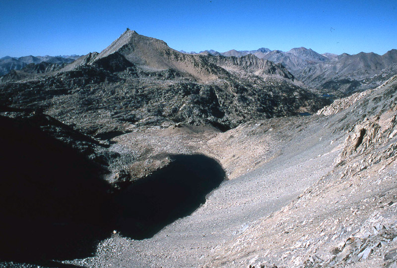
Photo 1. View to the north from Charlotte Col.
Lake 3435 is in the foreground and Mt. Cotter dominates the horizon.
To drop down into the 60 Lake Basin, we took the first major chute east of the low point of Charlotte Col. The first 200 feet was steep and loose, so we went one-at-a-time through a few sections. The remainder of the descent to Lake 3435 was rocky, but not difficult. We skirted around Lake 3435 on its east side, then hiked to the next unnamed lake in the drainage and camped on some flat rocks on the north side of the lake (waypoint CAMP1). We were now in great position to climb both Mt. Gardiner and Mt. Cotter tomorrow.
The next morning we hiked over 60 Lake Col and up the huge east face of Mt. Gardiner. Secor's guidebook (2nd ed.) appears to refer to this slope as the northeast chute, but looks more like a big scree slope almost due east of the summit. Once on the slope, Lisa and I took the middle, which had loose scree in places. Steve, Susan and John worked up steep slabs on the left side of the chute. We all met just below a small pinnacle near the SE ridge of Mt. Gardiner. Easy climbing around the right side of this pinnacle got us on the ridge within 100 feet of Gardiner's south summit. This approach to the south summit looked steep from 60 Lakes Col, but proved to be only class 2.
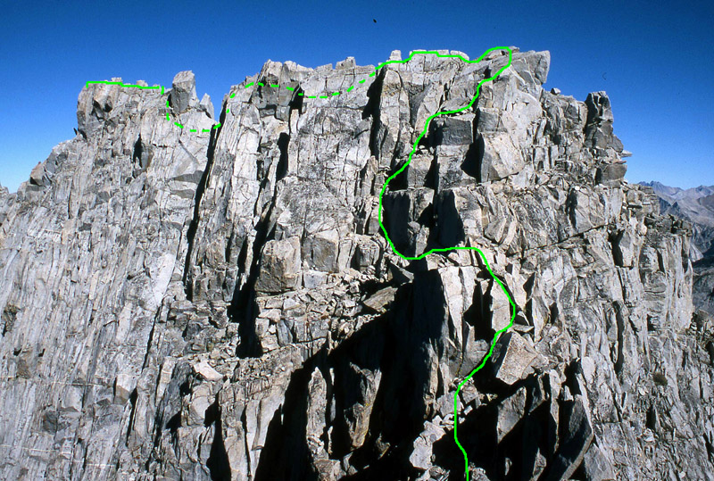
Photo 2. Mt. Gardiners' knife-edge ridge as viewed from the lower south summit.
The line represents our approximate route, with the dashed line portion indicating the route is on the other side of the ridge.
From the south summit, we dropped down along the ridge to the low notch, and then worked up towards the north summit, which is true the high point. Steve, Lisa and I took turns setting up one belay station each along the ridge in the more difficult sections, but most of the group climbed to the summit without protection. If one can ignore the large exposure, the climbing was only class 3 in difficulty, with one short climb up a dihedral near the summit that probably goes class 4. Typically, the one climber in our group that frequents a climbing gym scoffed at the notion that any part of the ridge went more than class 3. We dropped below the ridge on the north side when the ridge became more knife-edged, then worked back up to the ridge at the top of the short class 4 dihedral move. From here it was exposed, but easy, class 3 the final 20 feet to the summit.
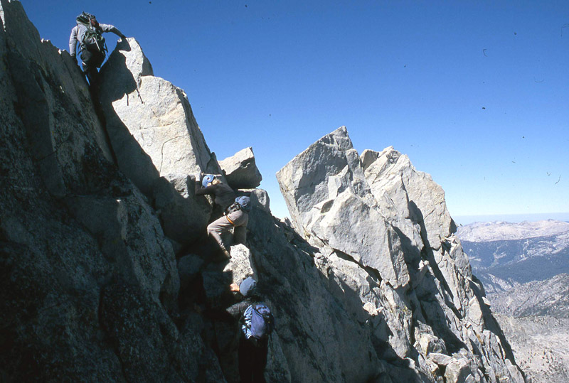
Photo 3. Nearing the summit: Steve reaching the ridgeline to set up a belay station,
with Lisa and Susan traversing below the ridge on one the more difficult sections of the climb.
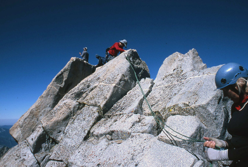
Photo 4. Mt. Gardiner high point. From left to right,
Steve and Susan on the summit, John almost there, and Lisa managing the belay station.
Our main climbing gear consisted of a 110 foot, 7.1 mm rope and several slings. This was all we needed, as there were plenty of rock horns to throw slings over. The knife-edge run to the summit went faster than expected and was quite fun for those who enjoy this sort of climbing. A nice diagram of the knife-edge traverse to the summit can be found in the July 1985 issue of the SPS Echo.
We retraced our route off the summit ridge after a nice 45 minute stay, and plunged-stepped through the scree down the east face. At the bottom, Steve and Susan headed back to camp. Both had already climbed Mt. Cotter. Susan was planning to relax at camp while Steve wanted to do a half-day loop trip through the Rae Lakes Basin. T he plan was to re-group with Steve later that evening near the 60 Lake trail, about one mile north of our current camp.
Lisa, John and I headed for Mt. Cotter's south ridge. Once on the ridge, we stayed mostly on the western side. We went right back on top of the south ridge at the summit blocks where the crux of the climb, a class 2-3 move, leads to the top. The register showed that Scott Sullivan had summited Cotter just two weeks before us; it was his 244th SPS peak with only 4 more to go. We descended back to camp via Cotter's southeast face and began packing up.
The one mile hike to the 60 Lake Trail went well except for the 150 foot climb up and over a buttress that blocked easy walking a round the west shore of Lake 3304...awfully tedious after a two-peak day. It looked possibly easier to skirt around the east shore of Lake 3304, but would still involve some steep climbing above its southeast shore. We set up camp (waypoint CAMP2) near our pre-arranged meeting spot, for which we had exchanged GPS coordinates before splitting up. Steve showed up just before dark about 30 min after we got there. He followed the trail to the southern lake and down-canyon to Arrowhead Lake, then turned up a nice cross-country route (the northern purple line on the map below, basically as described in Secor's book) to re-join the Sixty Lakes Basin trail.
We broke camp at 7:30 am and hiked out over Rae Col, then over Glen Pass, and then finally Kearsarge Pass back to our cars in Onion Valley. On our way up to Rae Col, we had a wonderful view of a Bighorn Sheep trotting across the mountainside. We had some discussion as to which low spot in the ridge was the real Rae Col, as there are two choices to go over this ridge. We chose the more northeastern one because it looked easier. About 200 feet below the Col we joined a sandy use trail that took us to the pass. Descending the south side to the Glen Pass trail went quickly, although there is no continuation of the use trail on the south side of Rae Col. We reached the cars before 4 pm and soon said our goodbyes...but not before making plans for the next mountaineering trip!
![]() Download the Waypoint+ data below as a GPX file for your GPS.
Download the Waypoint+ data below as a GPX file for your GPS.
Datum,North America 1983,GRS 80,0,-1.6E-7,0,0,0
Waypoint,D,CHARCD, 36.7832499743,-118.4353833199,11/15/2007,02:54:34,CHARLOTTE COL DESCENT ROUTE
Waypoint,D,CHARC1, 36.7843500376,-118.4215667248,11/15/2007,02:54:04,LEAVE THE TRAIL
Waypoint,D,CHARC2, 36.7860833406,-118.4233833551,11/07/2007,03:37:45,GO BELOW A BUTTRESS
Waypoint,D,CHARC3, 36.7889499664,-118.4240499735,11/07/2007,03:37:45,TOP OF THE CHUTE
Waypoint,D,CHACOL, 36.7947666645,-118.4329832792,11/07/2007,03:37:45,CHARLOTTE COL 11900
Waypoint,D,CAMP1, 36.8050700426,-118.4357899427,11/07/2007,03:37:45,
Waypoint,D,60LCOL, 36.8044599295,-118.4413499832,11/07/2007,03:37:47,
Waypoint,D,GARDIM, 36.8061499596,-118.4591900110,11/07/2007,03:37:54,
Waypoint,D,COTTEM, 36.8188899755,-118.4417300224,11/07/2007,03:37:53,
Waypoint,D,CAMP2, 36.8150899410,-118.4254800081,11/07/2007,03:38:04,
Waypoint,D,RAECOL, 36.7991340160,-118.4148395061,11/07/2007,03:38:02,
Waypoint,D,GLENPS, 36.7894899845,-118.4115799665,11/07/2007,03:37:54,