However, climbing Pilot Knob from the north did not seem to be without merit, as nearby Big Meadow is a good base camp for Pilot Knob, as well as other SPS List peaks including Sirretta Peak, Taylor Dome and Rockhouse Peak. The Jenkins book "Exploring the Southern Sierra: East Side" gave good driving instructions from Big Meadow that could get me within 5 miles of the peak. Darrick Danta also recently explored a driving approach for Pilot Knob from the north and said that dirt roads were in good shape with no closed gates hindering access. I was able to easily talk Steve into this little adventure because it was something new.
The short version for this northern approach is that we did successfully reach Pilot Knob. This route can be easily done as a dayhike by fit hikers with a high tolerance for bushwhacking. However, be warned this route has more bushwhacking opportunities than any other peak on the SPS List.
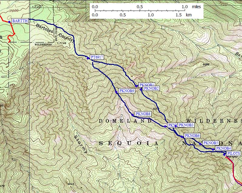
To get there, see Steve's detailed Bartolas Trailhead page (with maps and waypoints). We set up camp in a flat area beside the road, near waypoint BARTTH.
In the morning, we started hiking SE through forest and sparse brush towards Point 7146 on the 7.5-min map. This point is near the southern end of Bartolas Country, which is also considered the southern terminus of the Kern Plateau, and represents the beginning of the NW ridge route of Pilot Knob. As the terrain was forested and fairly featureless, Steve used his compass and GPS to keep us going in the right direction.
We skirted around Point 7146 on its NE side with little effort and saw Pilot Knob for the first time - the summit block really did look knobby - roughly 2.5 miles away and nearly 1000 feet lower than we were at the moment. This was going to be the first SPS peak that I actually climbed down to. The plateau quickly narrowed to more of a ridge as we continued SE towards Point 6917, but the terrain was still easy walking. However, the hiking/climbing difficulties increased dramatically soon after passing Point 6917, with increased brush density and more challenging route-finding along a narrow ridgeline.
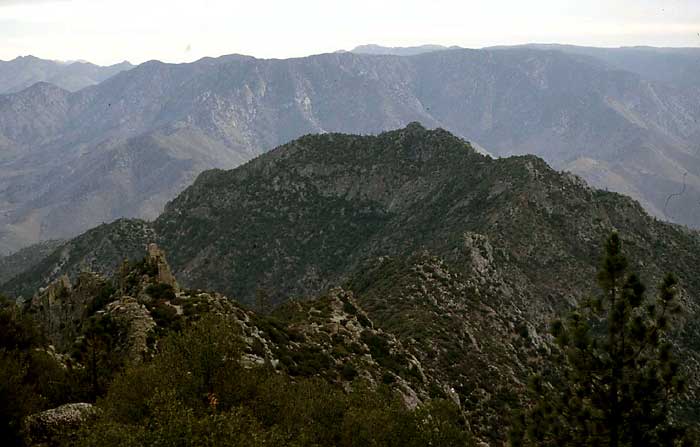
Photo 1: Pilot Knob and the NW ridge. The NW ridge starts in the lower left foreground of the photo, and goes towards the right shoulder of Pilot Knob in the middle of the photo.
Steve and I attempted to stay on or near the ridgeline trying to avoid the heaviest brush sections as we worked our way towards the peak. The most challenging route-finding occurred at waypoints PKNOB1 and 2, where we dropped off the ridge to the east to get around gendarmes and brush before working back up to the ridge. The rock climbing itself was primarily class 2 with a little class 3 in places and would have been fun, except for all the stinkin' brush! The bushwhacking was so intense at times that it felt like we were often fighting for every foot of forward progress towards Pilot Knob.
We passed Point 5972 on its west side then descended towards the low point on the ridge (5480 ft.+) where we decided we had had enough of the brush on the ridge. Just prior to the low point on the ridge (waypoint PKNOB3), we dropped down on the west side and contoured over towards a west facing gully on the Pilot Knob massif. Unfortunately, getting to the gully proved only marginally easier in avoiding brush. But the gully itself went easier and we managed to fight our way back up to the ridgeline, about 0.3 mi. from Pilot Knob's summit. We stayed mostly just below the ridge on its north side, occasionally popping up on top of the ridge to check our progress. We found occasional short sections of clear paths through the brush on the north side.
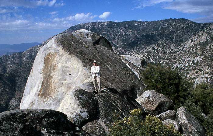
Photo 2: Steve on the ridge 0.3 mi. from the summit in full bushwhack attire...quite different from his normal clothing choice for climbing. The NW ridge is in the extreme right-hand corner of the photo, with the terminus of the Kern Plateau behind it. Just to the left of the NW ridge, the gully we used on our return can be seen ascending towards the top of the Kern Plateau.
At the base of the summit rocks we searched in vain for a route to the top up the west, north and south sides, but all were class 4-5 in difficulty. So we dropped down on the north side of the ridge again, and then contoured around to the east side of Pilot Knob where we joined the ducked standard route up to the summit. It took us 5.5 hours to reach the summit, nearly 5 hours of which was used up just to cross the last 2.5 miles of ridgeline to the summit.
The closing of the preferred SE approach, and the subsequent suspension of this peak from the HPS List, appears to have decreased interest in climbing this peak. Only one party of two had climbed the peak this year prior to our ascent. But they (Lisa Barboza and Louise Wholey of the Loma Prieta Peak Climbing Section) climbed it from the SW side, after asking permission from a ranch hand at the Doyle Ranch to cross the land to the base of the peak. Their SW approach route is shown on the climber.org Pilot Knob web page.
For our return we tried staying 100-200 feet below the north side of the ridge for the first 0.3 mile, where we thought the brush was less (waypoints PKNOB4 and 5). Steve thought this went better, but I thought we were doing just as much bushwhacking as we were up near the ridge. We were eventually forced up onto the ridge where it begins to drop to the low point on the NW ridge. We crossed to the west side, and then descended down below the ridge low point in a relatively brush-free chute (waypoint PKNOB6). Here we decided to contour down and across below the NW ridge, passing a distinctive large boulder with green lichen (waypoint PKNOB7), and eventually dropping down to about an elev. 5200 where we thought the brush was less dense (waypoint PKNOB8). The brush was less in places, but there were still pockets of dense brush we had whack our way through.
Our goal was to reach a gully that ascended up to Point 6917. On our traverse to Pilot Knob earlier in the day, Steve had spied this gully, which appeared to be largely free of brush. The map shows a stream running down this gully, but it was bone dry when we got there (waypoint PKNOB9). However, we were happy to find that it was mostly free of brush at the bottom and we were able to have a rather enjoyable 1600 climb with only had two bands of dense brush to cross. We lost the gully in these two brushy sections and stumbled around till we found a continuation of the gully. As we neared the plateau and gully became vague, we followed a string of tall ponderosa and sugar pine trees. The brush under the trees was less dense. Venturing outside of the line of trees led to nearly impenetrable brush.
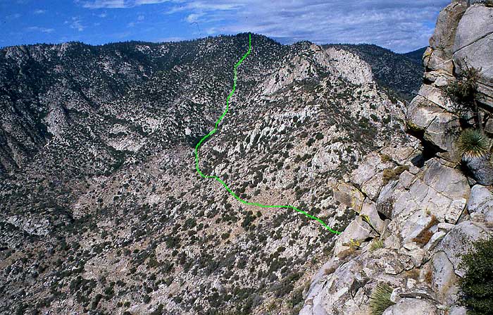
Photo 3: Our return route is shown marked on the photo. The marked line begins roughly at the low point on the NW ridge and ends at the top of the Kern Plateau.
Back up on the plateau near Point 6917 the bushwhacking was over. We took a short break (waypoint PT6917), and then quickly headed back to camp where Steve and I enjoyed a well-earned round of Corona beer, courtesy of Steve. Even though we had an extra 1000 feet of climbing on the return leg, and were quite tired from much bushwhacking, it took us 15 minutes less for the return leg of our journey. This was due mainly to taking the relatively brush-free gully up to the plateau on our way back. Clearly, if we were to do this route again, we would use this gully route, or some variation of it, in both directions. It was far better than battling the extensive brush high on the NW ridge itself. However, if a controlled burn some day clears the brush on the NW ridge, it would be a fine class 2-3 scramble to Pilot Knob.
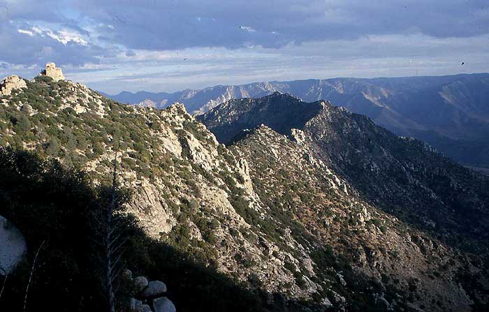
Photo 4: Last view of Pilot Knob and its NW ridge with daylight beginning to fade. Photo was taken high up in the gully, just below Point 6917.
Other useful factoids: Round trip distance was about 7 miles with total hiking time of 11 hrs 15 min, and 4300 feet of total elevation gain, most of it on the way back to camp. Although the map indicated about 3100 feet of gain, we got lots of bonus gain by constantly moving up and down across the terrain to avoid dense sections of brush. We easily kept the climbing difficulties to class 2 with occasional class 3 moves along the ridge. It got quite warm here even at the end of October with overcast skies most of the day. With the heat and the energy-sapping bushwhacking activities, I went through nearly all my food and found that 3 quarts of water was not enough for the hike. And did I mention that nearly all the brush we waded through had pointy needles and spines? There was an over-abundance of holly-like bushes with prickly leaves, and Yucca-type plants with spikes. Bring full-body armor for skin protection, including gloves for when you get tripped-up by the brush. Nearby Bartolas Creek was dry, so bring all the water you need especially if hiking this route mid- to late-season.
Static route map - see link below for interactive map
![]() Download the Waypoint+ data below as a GPX file for your GPS.
Download the Waypoint+ data below as a GPX file for your GPS.
Datum,North America 1983,GRS 80,0,-1.6E-7,0,0,0
RouteName,1 ,PILOT KNOB NORTH
RoutePoint,D,BARTTH, 35.7500100136,-118.2548400164,11/07/2007,03:38:06,BARTOLAS COUNTRY TRAILHEAD 7000
RoutePoint,D,PT6917, 35.7441252470,-118.2393350601,11/10/2007,21:42:38,POINT 6917
RoutePoint,D,PKNOB1, 35.7396099567,-118.2297199965,11/07/2007,03:37:46,TURN CLIFF ON THE NORTH
RoutePoint,D,PKNOB2, 35.7391099930,-118.2288700342,11/07/2007,03:37:46,TURN CLIFF ON THE NORTH
RoutePoint,D,PKNOB3, 35.7331542969,-118.2219264507,11/10/2007,22:41:27,LOW POINT OF THE RIDGE
RoutePoint,D,PILOTS, 35.7285900116,-118.2123399973,09/02/2005,14:31:54,1_1 PILOT KNOB S 6200
RoutePoint,D,PKNOB4, 35.7294199467,-118.2145600319,11/07/2007,03:37:46,ROCK FACE ON NORTH SIDE
RoutePoint,D,PKNOB5, 35.7302800417,-118.2170799971,11/07/2007,03:37:46,ROCK FACE ON NORTH SIDE
RoutePoint,D,PKNOB6, 35.7314699888,-118.2207200527,11/07/2007,03:37:47,BOTTOM OF GOOD CHUTE
RoutePoint,D,PKNOB7, 35.7331500053,-118.2240699530,11/07/2007,03:37:47,OPEN TERRAIN SOUTH OF RIDGE
RoutePoint,D,PKNOB8, 35.7349799871,-118.2304400206,11/07/2007,03:37:47,BRUSH BAND BEFORE DRY WASH
RoutePoint,D,PKNOB9, 35.7386900187,-118.2337199450,11/07/2007,03:37:47,DRY WASH GREAT FOOTING
RoutePoint,D,PT6917, 35.7441252470,-118.2393350601,11/10/2007,21:42:38,POINT 6917
RoutePoint,D,BARTTH, 35.7500100136,-118.2548400164,11/07/2007,03:38:06,BARTOLAS COUNTRY TRAILHEAD 7000