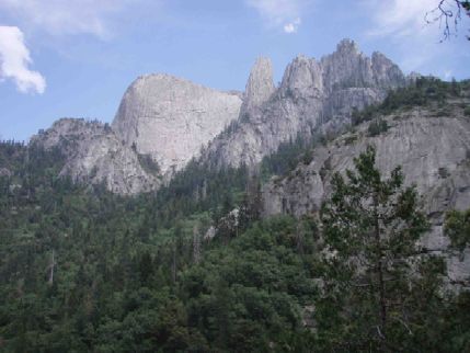
The Fin, Castle Rock Spire, and the Castle Rock group from the old Castle Rock Trail. Photo: Hal Tompkins
The approach began at the Buckeye Flat campground (2300 foot elevation) and spent less than a mile on a trail before starting up a steep ridge. After gaining 2500 feet we reached a local highpoint and began searching for the abandoned Castle Rock Spire trail. This trail was supposed to have been built in the 1930's but had been abandoned by the Park Service later. We found remnants that we were able to follow and eventually it got pretty easy to navigate. Of course there were still plenty of fallen trees across the trail to negotiate and other places where the trail was badly overgrown. Finally we reached the first water at around 2:45 PM. At this point we all stopped and washed our clothes and ourselves with Technu in hopes of removing the dreaded urushiol oil from the poison oak. We stashed the poison oak garb here and continued to the gully that descends from between Castle Rock Spire and the Fin. Another two hours of slogging uphill and we reached the "improved" campsite beneath a large boulder. It was a ten-hour day for us.
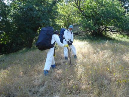
Two thirds of Team Tyvek heading up the ridge to the Castle Rock Trail. Photo: Rick Booth
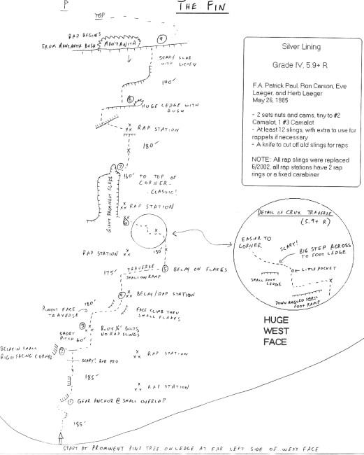
Friday morning we were up at 5 AM for the approach to the Fin. The guidebook said it was a 45-minute approach and that seemed about right. We screwed up the start a little bit but by 8 AM Rick was most of the way up the first pitch. I led the second pitch and Jim led the third pitch. We kept this rotation going for the entire climb, which gave us each three pitches to lead. Depending on the source, the route was rated 5.9 R/X or 10a R/X and there were many leadouts of 30 feet or more above the last piece of protection. Bolts were scarce (four protection bolts on the entire climb); most protection was from overlaps or cracks that would occasionally appear. The route wandered extensively, taking advantage of weaknesses in the angle of the rock. Several pitches had long traverses that were poorly protected for both the leader and the followers. Several pitches also had medium runouts right off of the belay. Plus, some of the belays involved gear behind flakes of questionable quality. In general the moves were characterized by positive edges on steeper rock as opposed to friction climbing. The crux was on pitch 6, and I thought it was much harder than 5.9. Fortunately it was right at a bolt and was well protected. I never could figure out the move but eventually solved it by pulling on the bolt. Pitch 7 was a big corner and was the only well protected pitch on the climb. We topped out a little after 6 PM and spent a short time perusing the summit register. The previous ascent was in 2004 and the one before that was in 2002. We think that our ascent was number 13! For reference, there is an excellent trip report on climber.org by Craig Clarence. His topo is much more accurate than the one in Moser, Vernon, and Hickey. We used 60m ropes as recommended by Clarence. The descent was (fortunately) uneventful. Seven rappels got us back to the ground. We were back in camp by 9 PM.
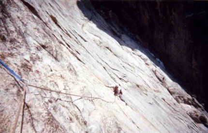
Hal on Silver Lining in about the same place as the picture in the Moser guide. Photo: Jim Curl
Saturday found us up again at 5 AM and heading further up the loose gully to the regular route on Castle Rock Spire. One obstacle in particular resulted in lots of lost time, whimpering, and rappelling back into the gully. So we didn't get a very early start on the route. Rick led pitches 1 and 5, Jim led pitches 2 and 4, and I led pitch 3. Most of the aid climbing was on pitch 2 and 4 (with a little bit of aid on pitch 5 as well). Again the rappels went well (we rappelled the route) and the rope never hung up. The sun had set before we started down the gully but we managed to finish the (only) rappel in the gully before it was completely dark. We staggered back into camp at 10 PM.
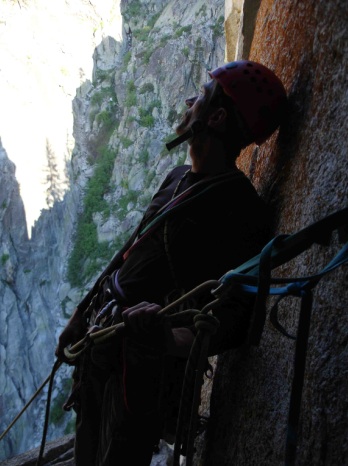
The end of the day. Jim Curl waiting at the last rappel station on Castle Rock Spire. Photo: Rick Booth
Relishing the freedom to sleep in on Sunday, we didn't start the return trip until 9:30 AM. We retrieved our "haz mat suit" and started wading through the poison oak again. Then we wasted an hour overshooting the correct ridge and had to backtrack so it wasn't until 4:30 PM that we reached the Buckeye Flat campground. First was another Technu bath for hands and face and then we lined the seats with garbage bags and put our packs in more garbage bags. Only then was it safe to drive off in search of a trailer park to take another Technu shower. Amazingly enough, all of these precautions actually worked.
Hal Tompkins
Rene Ardesch is a member of the Southern Sierra Climbers Association and has held an interest in the old Castle Rock Trail for years. Rene indicates the original start for the Castle Rock Trail starts approximately one to one and one half miles further down the Paradise Creek Trail from where we left this trail. Apparently there is a cut into the embankment next to the tail where the original Castle Rock Trail heads away from the Paradise Creek trail. This is apparently very overgrown now. The origins of the trail are unknown, Rene indicates it was either a Park Service Trail or a CCC trail put in sometime in the 30's. The cut out in the embankment is a characteristic of the Park Service, however. The trail was abandoned in the 70's, probably for budgetary reasons. Rene indicates that there is usually water at the campsite area year round except in drought years.
This is a link to the Southern Sierra Climbing Association website. I have run into these people at Joshua Tree and they are a good group. http://www.southernsierra.org/sscahome.html [broken link as of 2009]
This is a great adventure type project! It is not very often that you can be the 13th ascent party on a route that is twenty years old. Both The Fin and Castle Rock Spire are easily seen from the southern entrance to Sequoia National Park and they are awe inspiring when seen from the road.
Get a permit. The office opens at 8 AM and is behind the visitor center on the south entrance. A permit can be reserved three weeks in advance but you still have to pick it up at the backcountry office. If you go before Memorial Day you can self register. An early start is strongly suggested since it gets hot early at this low elevation.
The car can be parked just off the road on the road into Buckeye Flat campground. There are two spots on this road, one at a turn to the left and one near the top before the road heads downhill to the Buckeye Flat campground. Don't leave food in your car, bears are all over this place.
Visit the link to the Bruce Binder report and copy the GPS waypoints onto a map. The most important one is the waypoint indicating the point where to leave the Paradise Creek Trail. This is waypoint three. Once you hit this waypoint head straight uphill. This will eventually intersect a section of the old Castle Rock Trail. We followed this and somehow missed a turn off of it to contour around Bump 5170, as indicated on the map and Binder's waypoints. Oddly enough, there was a trail that went over the top of this bump, or at least very near it. The trail gets indistinct after this and heads back down the backside of Bump 5170 to a plateau where it eventually rejoins the trail. Mark this junction with a cairn. When returning, this junction is easily missed (we missed it) . The trail on the return hike takes you along the trail that contours below Bump 5170. This is a hellish area of poison oak and it is not recommended to use this trail. As Hal and I were standing on a slope absolutely paved with poison oak trying to find a trail remnant, Hal commented, "This is a fearsome place", and he was right. If possible, go back up over the top of Bump 5170. Finally, when returning, the trail stays in good shape right up to the end of it which terminates in a good sized cairn. Unfortunately, this is too far, although it is possible to go down from there, according to Rene. Back track a ways and start looking for use trails that leave the main trail and bring you back to the top of the ridge that was used to ascend to this trail. There are no ducks or cairns marking this so it might be a good idea to put one in on the ascent, if possible (if there are any rocks there). There are a few ducks to mark the trail up and down the ridge which were apparently put in last December.
Get a real Tyvek clean room suit. I ordered mine over the internet and they were a little late arriving so I bought what looked like a haz-mat suit at Home Depot. It was very porous and I am convinced I would have been in big trouble if I had used that suit. Fortunately, the "real deal" showed up. Soak or spray the suit in Permethrin. This should help to keep the ticks off. These suits tear fairly easily. Either bring some tape to patch the suit or bring an extra suit. Jim brought an extra suit and I think that is a better idea. Also, the reports indicate there is no poison oak past the stream crossing before going up hill. This is no longer accurate. An extra Tyvek pair of pants only for this section would be handy and should weigh very little. Bring gloves and gaiters. Wear a pair of decent boots that are stiff enough to get a bite on the edge. I used approach shoes and that was a big mistake. The trail is soft in some places and I slid off several times. Furthermore, going up and down the ridge requires hiking through steep grass which is slipperier than Teflon and having the extra bite in my boots would have saved me from several more butt slides. Finally, there have been reports of rattlesnakes and bears in this area and although we don't think we ran into either, some critter scattered Jim's clothing and suit which was left behind at the stream crossing.
You will need a double 60 meter rope system for The Fin and it is needed for Castle Rock Spire for the rappels. We brought a rack of double stoppers and cams from tiny aliens up to #2 camalot. We added one #3 camalot and one #4 camalot. The #4 is used on the offwidth on the first pitch of Castle Rock Spire and can be used on the crux on the 5.11b second pitch. We ascended the first pitch of Castle Rock Spire directly and did not use the 5.6 traverse as indicated by the Bruce Binder topo. This makes the first pitch about 200 feet.
The times listed by Hal for the hike in and out are long. Bullet hiker types can do this much faster as long as they don't have a 59 year old weasel going with them. Jim and Bob Suzuki made it in eight hours on their first trip and Ron Hudson has reported 6.5 hours of time to get to the bivy site. This assumes some reasonable competence in keeping close to the trail.
This is a link to Bruce Binder's description of the Castle Rock Spire routes: http://www.summitpost.org/mountain/rock/153485/castle-rock-spire.html
This is a link to Craig Clarence's description of the Silver Lining on The Fin route: http://www.climber.org/TripReports/2002/874.html
Craig has a nice topo of the Silver Lining route but the web accessible .jpg does not seem to have super good resolution so either email Craig or me to get a copy. http://www.summitpost.org/images/original/11435.jpg
Southern Sierra Rock Climbing: Sequoia/Kings Canyon, Sally Moser, Greg Vernon, David Hickey. Chockstone Press (now Falcon Publishing), 1993. ISBN 0-934641-51-X This may be out of print or very difficult to find. Try Amazon used books.