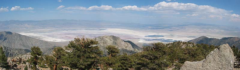
Owens Valley from Cartago:
|
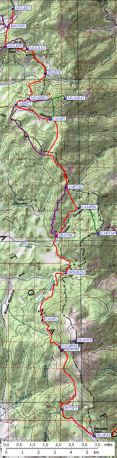
Static map is to the right, waypoints for the backpack and climbs are below.
With the waypoints is a link to an interactive map.
I had done all these peaks before (Muah as a dayhike from Horseshoe, Cartago as a dayhike and as an overnight from the canal, and Olancha as an overnight from Sage Flat) but connecting them as a one-way backpack offered some new terrain and a touch of route-finding. The hardest thing to figure out was the car shuttle, which Paul Magliocco made easy with his minivan. Two cars, two drivers, one seats-everyone vehicle at Sage Flat, and we're ready to go. There are several ways to reach Mulkey Pass (MULKPS), as detailed on the trailhead page. We followed the red line on the map, over the pass and down to Diaz Creek. This is not the most inspiring place I've ever been. Mark Adrian used to call this and/or Ash Meadow "Cow Plop Meadow" because cattle are allowed to fowl the streams and trample the meadows. We followed the PCT south to the headwaters of Ash Meadow (ASHJCT), which is larger and flatter than most Sierra meadows, then walked down to where the meadow steepens into Ash Creek. We set up camp in what felt like Golden Gate Park, with the flat lawn and all (CAMP1). Muah fails to impress from this vantage. A second-class romp to Muah (the green line) completed our first day. The next morning we walked south on easy brush-free terrain to re-join the PCT for about 2 miles, then dropped cross-country (from CARTXC) into upper Death Canyon. This canyon was the best part of the trip for me, with interesting cliffs and trees. Sadly we spent little time here, dropping our packs at what might have been a good campsite (CAMPDC), scooting over to Cartago, then packing back down to the PCT (DEATHC). Cartago was, as always, hard to find. Bob Suzuki made fun of me for carrying a GPS, so I "invited" him to find the peak without consulting my Garmin Geko. After climbing two false summits and enduring my beaming smile, he relented. Cartago is a short class 3 climb, which others have described well. Back on the PCT where Death Canyon meets Big Dry Meadow (yummy names), we were inundated with mosquitoes! The snow had all melted but it was not dry here in early June. We pounded past Dry and Gomez meadows, then started climbing toward Olancha. This was our longest day so we camped at the first good water above the meadows (CAMP2, a stream around 9.7k). There was another better campsite 600' higher (CAMPOX), but we didn't know that at the time. Leaving the trail at the shoulder high point (OLANXC) we scrambled over boulders with some brush to the top. Here we felt very lucky to be under clear skies watching a storm cloud maliciously target Langley. The rest of the trip is just a blur of trudging down the trail to Sage Flat. This trip could be done in 2 days if you set up the car shuttle first. We spent time moving cars the day we packed in, giving us a late start. We were there in early season so be careful about relying on the sources of water we found if you're there in the fall.
|
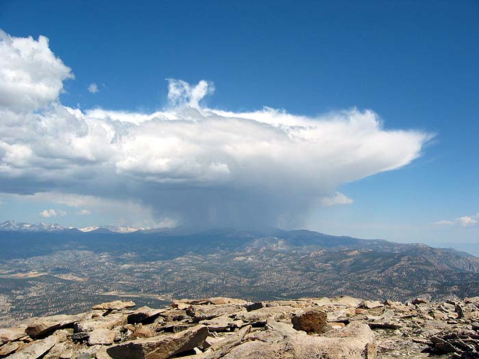
|
Rain dumping on Mt Langley, but not on Olancha!
GPS Waypoints
![]() Download the Waypoint+ data below as a GPX file for your GPS.
Download the Waypoint+ data below as a GPX file for your GPS.
Datum,North America 1983,GRS 80,0,-1.6E-7,0,0,0
RouteName,1 ,PEAKS
RoutePoint,D,MUAHMT, 36.4004100561,-118.1251699924,09/02/2005,14:31:54,3_3 MUAH MTN 11016
RoutePoint,D,CARTAP, 36.3247833252,-118.1021332741,09/02/2005,14:31:54,3_2 CARTAGO PEAK 10480
RoutePoint,D,OLANCP, 36.2650500536,-118.1181000471,09/02/2005,14:31:54,3_1 OLANCHA PEAK 12123
RouteName,2 ,BACKPACK
RoutePoint,D,MULKEY, 36.4506499767,-118.1613600254,04/15/2003,17:40:24,MULKEY PASS TRAILHEAD 9900
RoutePoint,D,ROUNDV, 36.4405100346,-118.1646599770,06/02/2003,20:47:45,
RoutePoint,D,MULKPS, 36.4295400381,-118.1666899920,06/02/2003,20:47:57,MULKEY PASS
RoutePoint,D,MULKAT, 36.4284600019,-118.1513999701,06/02/2003,20:48:14,ALTERNATE TRAIL JCT
RoutePoint,D,DIAZCK, 36.4145100117,-118.1389299631,06/02/2003,20:48:57,NEAR DIAZ CREEK
RoutePoint,D,MUAHXC, 36.4005517960,-118.1507036686,06/02/2003,20:49:28,XC TO MUAH FROM HERE
RoutePoint,D,ASHJCT, 36.3971576691,-118.1590640545,05/18/2011,16:30:49,ASH MDW XC JCT
RoutePoint,D,CAMP1, 36.3887499571,-118.1353499889,06/18/2003,03:58:40,OK CAMPSITE
RoutePoint,D,CARTXC, 36.3507717848,-118.1245727539,06/02/2003,20:52:25,XC TO CARTAGO FROM HERE
RoutePoint,D,CAMPDC, 36.3394000530,-118.1153999567,06/14/2003,16:16:33,GOOD WATER COULD CAMP DEATH CYN
RoutePoint,D,DEATHC, 36.3236700296,-118.1313899755,06/02/2003,20:52:01,XC TO DEATH CANYON
RoutePoint,D,GOMEZM, 36.3029999733,-118.1245499849,06/02/2003,20:54:44,GOMEZ MDW
RoutePoint,D,CAMP2, 36.2768100500,-118.1407699585,06/08/2003,14:00:07,SMALL STREAM GOOD CAMP
RoutePoint,D,CAMPOX, 36.2615699768,-118.1292300224,06/18/2003,04:08:58,WATER HERE, COULD CAMP
RoutePoint,D,OLANXC, 36.2599849701,-118.1270549297,06/02/2003,20:55:14,XC TO OLANCHA FROM HERE
RoutePoint,D,PCTJCT, 36.2269200087,-118.1272100210,06/02/2003,20:55:59,PCT JCT SUMMIT MDW TRAIL
RoutePoint,D,OLAPAS, 36.2120100260,-118.1050100327,06/02/2003,20:56:23,OLANCHA PASS
RoutePoint,D,SAGETH, 36.2256799936,-118.0614099503,06/02/2003,20:57:01,SAGE FLAT TRAILHEAD