South Fork Kaweah River
Revised 25 May 2015 - please send updates to the webmaster
Exit Hwy 99 at Hwy 198 (waypoint 099198), following signs for Sequoia / Kings Canyon national park, as described in Visalia to Three Rivers. Go through Visalia on freeway, which is 65mph and below grade so you don't see anything like filling stations or restaurants. Cross Hwy 63 and continue out of town - yes, that was Visalia you didn't see. Before the freeway ends, there are traffic lights where you can find a couple of filling stations with fast food outlets. The freeway ends just east of the traffic lights at Hwy 245. Two miles after Hwy 245, Hwy 198 starts to turn north at waypoint YOKOHL.
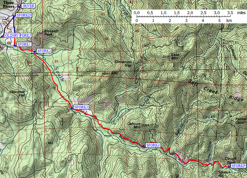
The regular well-marked turn from Hwy 198 to Southfork Drive is just after the Three Rivers golf course (waypoint SFORKD), but since we're optimizing we'll turn before that intersection, east onto Old Three Rivers Road (waypoint OLD3RV). This becomes Blossom Road and intersects Southfork Drive at a 4-way stop sign (waypoint SFORKJ) about half a mile from Hwy 198. Turn right (south) onto Southfork Drive and follow the main road all the way to the end. On your way out this will be the only stop sign (waypoint SFORKJ) and you can turn left. Or, if you want dinner in Three Rivers, go straight and reach Hwy 198 much further north at SFORKD.
|
South of waypoint SFORKJ, you follow the
South Fork of the Kaweah River for about 10 miles. You'll notice the road
goes from wide to narrow to dirt to rock before reaching the campground
where there used to be a ranger station. I'm not certain whether this
campground is free, but it seems to be well used in the winter and spring.
There is a public use bear box by the campground outhouse.
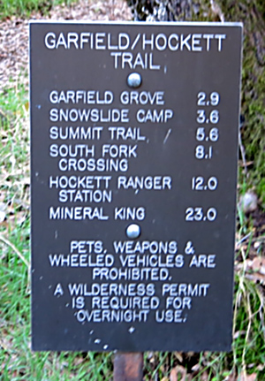
A few yards past the last campsite is the end of the road and trailhead parking (waypoint SFORKP). There is another large bear box here and non-potable water for horses, but no other facilities. (It's a bit of a walk to the campground outhouse.) The Ladybug Trail crosses the river on a bridge, where you can scramble down to running water, and can be used to reach Homer's Nose. The Garfield-Hockett trail leaves the south side of the road just down-canyon from the parking area, and can be used to climb Dennison Mtn as a day hike or to reach Hockett Meadow for climbing Vandever or Homer's Nose. |
There is no longer a sign for Clough Cave, even though various maps show such a cave at the end of the road!
David Huff adds in 2003:
The reason that you missed Clough Cave is that it is not marked and the rangers discourage entering it. I have been in it 2-3 times and it is a safe cave for novices, i.e. only one way in and out. To find it you walk north of the campground and cross the river on the bridge. On the north side of the river there will be a trail heading east. Look up the hill to your left and you will see a faint trail heading west. It is very hard to see. Walk west and the trail will climb. Eventually you will be on a narrow ledge 50-75 feet high. It curves to the right and you will see the entrance. The rangers made an attempt to put up a gate but somebody ripped it off. The last time I was there was 10 years ago. I was first in the cave in the middle 60s and took a few photographs. I returned in the late 80s and took a few more photographs. Quite a bit of damage has been done to the few formations there. Some have been sawed off. It is just a small cave but there are other openings near there that are more extensive. Only Spelunkers should enter them. This is the extent of my knowledge I have taken all of my sons there when they were 6-8 years old. The only danger is the ledge.
Useful Links: