Southern Sierra Trailheads
(Walker and Sherman Pass area)
Revised 1 Dec 2015 - please send updates to the webmaster
To get to the Southern Sierra, see these pages:
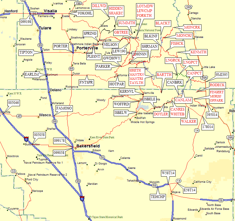
Click on the map or scroll down to find links to each of the trailheads shown on this overview:
|
Southern Sierra Trailheads (click on any red label) and Junctions
| ||
| waypoint | trailhead | comments |
| � | Bakersfield from the west | crossing from I-5 to Hwy 99 via Hwy 58 or 46 |
| DILLWD SHAKEC HIDDEN | Mountain Home | Mountain Home State Forest and Dillonwood Grove south of Mineral King and South Fork, east of Visalia |
| SUMMTH | Summit Trailhead | eastern approach to North Maggie |
| LEWCMP LOYMDW | Jerkey Meadow | southern trailheads for Coyote and Angora Jerkey Meadow via Lewis Camp or Lloyd Meadow |
| FORKTH | Forks of the Kern | Kern River whitewater access |
| BLACKT | Blackrock Trailhead | for Kern Peak |
| MONCRK MONCHJ | Monache Meadows | western approach to Olancha (summer only), PCT access shortest approach to Smith Mtn |
| KENMTH FISHCK | Southern Kennedy Meadows | Kennedy Meadows trailhead for Crag Peak Fish Creek campground for loop including Smith Mtn and Crag Pk |
| SIRETH MANTRN MANTRS TAYLTH | Big Meadow | trailhead for Siretta Mantern Mdw North for western approach to Rockhouse Mantern Mdw South for western approach to Rockhouse trailhead for Taylor Dome |
| LNGPCT LNGRCK CANPCT CANLAM | Canebrake Road Trailheads | CLOSED ROAD access to PCT between Long Valley and 9 Mile Canyon Long Valley for eastern appraoch to Rockhouse western approach to Sawtooth (S) and Spanish Needle via PCT for Lamont Peak |
| RODECK | Rodecker Flat | eastern (all year) approach to Spanish Needle |
| FINGRT MORISJ OPPARK | Owens Peak Area (northeast of Walker Pass) | Indian Wells approach to Five Fingers Indian Wells approach to Morris Peak Indian Wells approach to Owens Peak |
| CANRES WHTBR1 WHTBR2 CANRES DOYLER | Pilot Knob (S) | near Lake Isabella - all Pilot Knob approaches are on private land! |
| WALKER | Walker Pass | Pacific Crest Trail (PCT) crosses Hwy 178 (all-year access) |
You have four options depending on where you're going and your enjoyment
of winding mountain roads. The fastest way to cross between I-5 and Hwy 99
is on Hwy 46 through Wasco. The speed limit may be the same on 5 and 99,
but traffic moves faster on I-5 and there's less congestion because you
don't go through any towns. Then again there may be more fog, dust, and wind
on I-5, so drive safely.
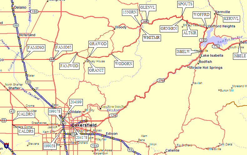
Continue southeast to South Granite Road, where you bear left.
Almost immediately you come to the intersection of Granite Rd and Woody Road
(waypoint GRAWOD) where you again stay right and follow the sign pointing
to Kernville 20 miles (via Granite Road). Skirt south and east of Woody
(waypoints WODGRN and WHITMR) on relatively fast road. Ignore all the side roads!
Finally Granite Road reaches Hwy 155 8 miles east of Woody (at waypoint 155GRN).
Once on Hwy 155, follow it east through Glennville (2 miles to waypoint GLENVL).
East of Glennville the road gets more winding (waypoint SPOUTS) and goes over
6100' Greenhorn Summit (waypoint GRNHRN) where there is a ski area. Go through
Alta Sierra (waypoint ALTSIR) down an 11% grade to Wofford Heights (waypoint WOFFRD).
Now use GPS Route ISABELLA KERN to follow Hwy 155 south about 7 miles to Hwy 178 in
Isabella (waypoint ISBELW), or go north 5 miles to Kernville (waypoint KERNVL) and
continue to the Sherman Pass Road (waypoint KERNSP).
Going home you may miss the turn on Hwy 155 (waypoint WOFFRD) because there's
only a small green highway sign. The turnoff is before the road climbs steeply to the
south of Wofford.
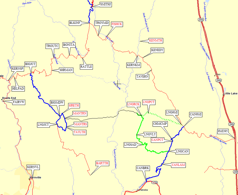
The east end of Sherman Pass Road connects to the southern Kennedy Meadows.
If you're using Kennedy Meadows as a trailhead, make sure you know which
one! There are two Kennedy Meadows in the Sierra Nevada, many miles apart.
The other one is described by the Kennedy Meadow (N) page.
Another way to get to Kennedy (S) is via Canebrake Road.
To go toward (or over) Sherman Pass from the west, follow
the Kern River north from Lake Isabella (GPS Route ISABELLA KERN) and
turn right north of "Roads End" (waypoint FAIRVW, which clearly is NOT
the end of the road). GPS Route SHERMAN PASS starts at the Kern River
north of Lake Isabella (waypoint KERNSP).
There is a sign here pointing east to Big Meadow
and Sherman Pass.
As you climb steeply up the 5000' grade to the pass, you pass a
helicopter pad (waypoint HELPAD) and endure countless switchbacks
through a recently-burned forest. Not all that pretty.
There are many 'trail' signs on the Sherman Pass Road, but they are for
motorized offroad vehicles. The first climber's turnoff is the signed
junction for Big Meadow (waypoint BIGJCT)
roughly 6 miles from the Kern River and just below 6000'. Trails near
Big Meadow lead to Sirretta, Taylor, and Rockhouse.
The endless switchbacks continue up to Sherman Pass
(waypoint SHRMAN, 9200') where the road becomes a bit straighter.
But only a bit. The 4WD trail signs are plentiful, and at
waypoint BONITA there is a major intersection that you go
straight through, following the Blackrock Information Station
sign and staying on the larger paved road which goes east for
a bit and then turns due north toward Blackrock.
The Blackrock Information Station has the only facilities in
the area. I didn't see a pay phone, but there are toilets and
a spigot (working in early October) accessible even when the
visitor center is closed. Sherman Pass Road is
far more winding and slow to the west of Blackrock than it is to the east.
The turn to Blackrock (waypoint BLKINF) is well signed.
You go north here if you're headed to the Blackrock trailhead
(for Kern Peak) or the Monache Meadows Jeep Trail
(for Smith and the west side of Olancha). Otherwise follow
the main road southeast to Troy Meadows (waypoint TROYMD)
where there are campgrounds on both sides of the road.
Less than 2 miles east of Troy is the Fish Creek Campground
(waypoint FISHCK). There's a 4WD road and 2WD parking here,
and Jackass Meadow is a trailhead for Crag and/or Smith.
Now the road really mellows as you continue east to
Kennedy Meadows.
There's a bridge across the South Fork
Kern River (waypoint KERNKM) just as you enter the meadow,
and there's a small general store (waypoint KENEDY) at
the fork which leads north to Kennedy Meadows Campground
(a trailhead for Crag) or southeast to Nine Mile Canyon
and Canebrake Road.
The Sherman Pass Road technically ends
somewhere in here, and becomes the Kennedy Meadows Road,
and then becomes Nine Mile Canyon Road. About a mile SE of the
Kennedy Meadows general store is the Grumpy Bear Tavern
(waypoint TAVERN), where I once had a good dinner.
Roughly halfway from Hwy 395
to Kennedy Meadows (12 miles from each)
there are two dirt road junctions. The one closer to Hwy 395 is
a major intersection with a Chimney Peak Rec Area monument but nothing
that says what road it is (waypoint CAN9MI) - this would be the
northern end of Canebrake Road,
which may be called Chimney Basin Road
between here and the Chimney Creek Campground (waypoint CHMCMP).
The other dirt road junction, half a mile closer to Kennedy Meadows,
is the north end of the old Long Valley Loop Road (waypoint LNG9MI)
which is now CLOSED permanently. To access Rockhouse Basin you'll need
to go all the way around the other end of the loop from
Canebrake Road.
Nine Mile Canyon road between Hwy 395
and Kennedy Meadows
is usually plowed in the winter, but Canebrake and the
Sherman Pass Road beyond Kennedy are not plowed.
GPS Routes WALKER PASS and ISABELLA KERN (see overall map)
represents the waypoints to follow Hwy 178 (from
just east of Bakersfield)
past Lake Isabella and over Walker Pass to
Hwy 395 by way of Hwy 14. You can get gas in Lake Isabella, and there
are a couple of restaurants there, but much better food and much longer
hours are the norm a few miles north in Kernville (waypoint KERNVL).
Kernville serves the fishing/camping/hunting crowd that spends a lot of time
and money along the Kern River. To find restaurants and a grocery store
in Isabella, get off Hwy 178 at Kernville Road (waypoint ISBELW), jog
southeast over to Lake Isabella Blvd, then go half a mile south toward Bodfish.
Lake Isabella (waypoint ISBELW) is the starting point for the drive up
the Kern River to Big Meadow, Sherman Pass, and
Blackrock (GPS Route ISABELLA KERN). Going past
Isabella to the east leads you to trailheads for Pilot Knob and all the
Canebrake Road trailheads.
Canebrake is the short way to Kennedy Meadows
from here, but going over Walker Pass and up Nine Mile Canyon is paved
and you may make better time.
GPS Route TEHACHAPI PASS (see overall map)
represents the waypoints from Hwy 99 (just south of Bakersfield) to Hwy 395 by
way of Hwy 58 and Hwy 14, over Tehachapi Pass. This pass is all freeway, and
doesn't tend to ice up in the winter, but is longer than Walker Pass.
From Hwy 99 in Bakersfield, take Hwy 58 east over the pass. No tricks here,
but if you want to save a little time you should take the Randsburg Cutoff
from Hwy 58 (waypoint W58T14) to Hwy 14 (waypoint E58T14). This shortcut
continues east where Hwy 58 abruptly turns south toward Mojave. Of course
if you're needing dinner or gas, Mojave is the place to be!
Once on Hwy 14, go north past Inyokern and join Hwy 395 for access to the
eastern sierra or the eastern approaches to
the southern sierra (listed above).
Useful Links:
Eastern Approaches from Hwy 14 or Hwy 395:
Western Approaches from Hwy 99 or I-5:
Most people follow Hwy 178 NE from Bakersfield
to Lake Isabella (GPS Route WALKER PASS).
From the west end of Lake Isabella (waypoint ISBELW)
you can either continue east (still on GPS Route WALKER PASS) to
Canebrake Road (waypoint CANBRK) or
turn north up the Kern River (GPS Route ISABELLA KERN), cross at Kernville
(waypoint KERNVL) and continue on to Sherman Pass. Contrary
to the place name Roads End, near the Fairview Campground (waypoint FAIRVW) the
road does not end. Keep going to the Sherman Pass Road (waypoint KERNSP) if
you're going climbing, or a few yards further to the Parker Pass Road
(waypoint KERNPP) if you're testing your car. The lower reaches of the
Kern River (along 178) are beautiful during the day, but for some the steep
narrow canyon is terrifying or slow at night. Fast drivers will want to avoid
peak traffic times since motorhomes tow boats up this grade, and that
can really slow you down.
Map of western approach GPS Routes WALKER PASS, HWY 155, and ISABELLA KERN
If you're coming from Northern California, you can save considerable
mileage BUT NO DRIVE TIME by taking Hwy 155 (GPS Route HWY 155) east to
Wofford Heights on the west shore of Lake Isabella (leaving Hwy 99 long before
you get to Bakersfield). If you do this the
simple way, leaving Hwy 99 at near Delano, you'll have roads just as winding as
Parker Pass. You can avoid most of the winding mountain roads if you continue
east from the intersection of Hwy 99 and Hwy 46 near Famoso (waypoint FAMOSO).
Hwy 46 is the best way to get from I-5 to Hwy 99, so just keep going across
Hwy 99 - and turn east at a small sign between the overpass and the gas station.
You're now on the Famoso-Woody Road, which immediately crosses railroad tracks
and then goes straight/level across Hwy 65 (the stop sign at waypoint FAMO65).
Bear right at the triangular intersection with Tule Road (waypoint FAMWOD).
For the longest route, but with the straightest roads with the least risk
of snow, see GPS Route TEHACHAPI PASS. Follow Hwy 58 SE from
Bakersfield over Tehachapi Pass,
bypass Mojave, and go 40 miles north on Hwy 14 to Hwy 178 (waypoint 178014).
Continue north on Hwy 395 to reach Ninemile Canyon (waypoint 3959MI).
This is a really bad choice if you want to reach trailheads west of
Sherman Pass, but not so bad for Canebrake Road
and Kennedy Meadows.
If you're headed for Sherman Pass or
Lloyd Meadow, Jerkey Meadow, or Lewis Camp, and if you really like
mountain roads with endless corners, consider Parker Pass. Leave Hwy 99 on
Sierra Avenue east from the town of Earlimart (waypoint EARLIM), go up and
down to California Hot Springs (there's a public parking area at waypoint CALHOT),
and watch for the hard left turn where Hot Springs Road meets Parker Pass Road
(waypoint HOTPAR) - follow the sign for Kernville and Johnsondale - which is
a left turn in the middle of a hairpin where the main road appears to go right.
On the way back, go to California Hot Springs and NOT Pine Flat!
Now it gets even more winding and steep as you go over Parker Pass
(waypoint PARKER) to the 4-way stop sign and and rest stop that mark the
southern end of the Great Western Divide Highway (a fancy name for the
winding road to Camp Nelson and Mountain Home).
Turn right toward Kernville at the T intersection just north of Johnsondale
(waypoint JOHNSN - and watch out if you're using a road-aware GPS because some
mapping software wants you to follow an abandoned road that no longer exists).
Eventually you drop to the Kern River (waypoint KERNPP) and jog slightly
south to the Sherman Pass Road (waypoint KERNSP). This route looks short on
a map (less than 70 miles), but it can easily take two hours to drive from
Hwy 99 to the Kern River!
Map of western approach GPS Routes CAMP NELSON and PARKER PASS
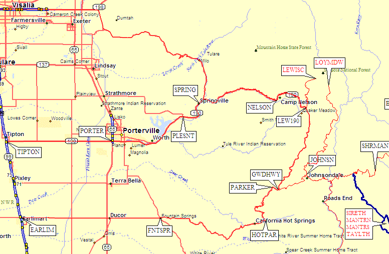
If you're headed for Lewis Camp, Camp Nelson
is the way to go. Leave Hwy 99 on Hwy 190 east from the town of Tipton
(waypoint TIPTON), go through Porterville, Pleasant Valley, and Springville
(waypoints PORTER, PLESNT, and SPRING) to where the road REALLY gets narrow
and winding. Camp Nelson (waypoint NELSON) is on the map but has no services
(stop in Springville for gas and food). Turn off to
Lewis Camp (Golden Trout Pack Station,
Jerkey Meadow, trailhead for Coyote and Angora) at waypoint LEW190.
You can continue on to the turnoff for Lewis Camp or Lloyd Meadow
(waypoint JOHNSN) but if you're going that far you'd be better off going over Parker Pass.
Sherman Pass: between Hwy 395 and the Kern River
(via Canebrake Road, Kennedy Meadow, Blackrock, Big Meadow)Click on the red map labels or scroll down to find links to each of the Sherman Pass trailheads:
Hwy 178 - Walker Pass - Hwy 99 (Bakersfield) to Hwy 14 (Inyokern)
(with access to the Kern River, Canebrake Road, Sherman Pass, etc)
Hwy 58 - Tehachapi Pass - Hwy 99 (Bakersfield) to Hwy 14 (Mojave)
(all freeway, but no access to Kern River or Lake Isabella area)