Sherwin, Valentine, and Laurel Creek
Revised 11 Jun 2012 - please send updates to the webmaster
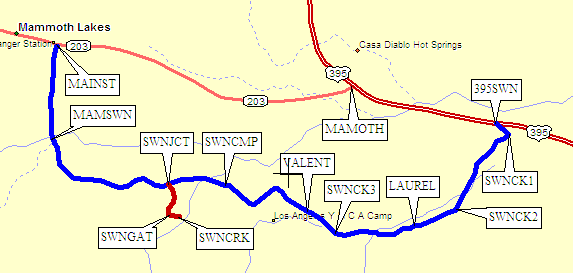
Continuing in this direction, Sherwin Creek Road comes out on Hwy 395 (waypoint 395SWN), 1.5 miles east of waypoint MAMOTH. This portion of the road is very rough, but quite drivable with any vehicle. Washboards keep your speed down so it's probably faster to drive through Mammoth Lakes except for the Laurel Creek Trail.
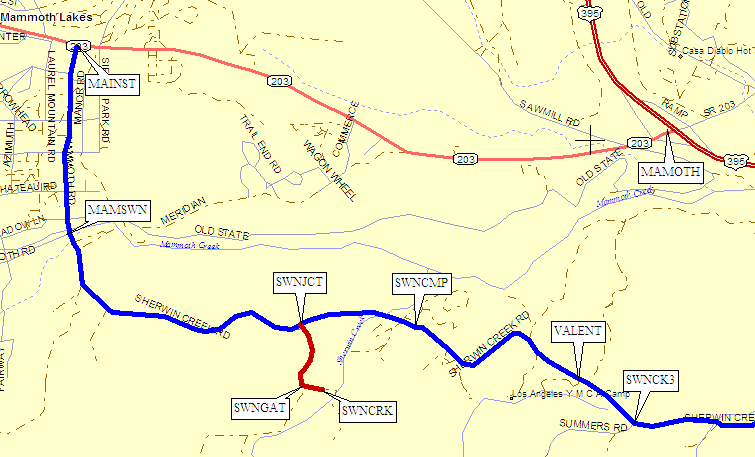
Sherwin Creek Road, which is intermittantly paved after the Valentine Lakes trailhead, continues west and then turns north, passing the Sherwin Creek, Valentine Lake, and Laurel Creek trailheads.
Continuing in this direction, Sherwin Creek Road ends at Old Mammoth Road (waypoint MAMSWN), which comes takes you to Hwy 203 (waypoint MAINST) also called Main Street in Mammoth Lakes. Follow this road east 2.8 miles to Hwy 395 (waypoint MAMOTH).
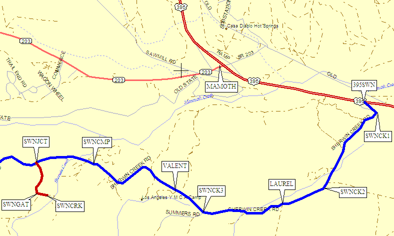
About 1.3 miles from Old Mammoth Road (waypoint MAMSWN) when coming from Mammoth Lakes via the good road, or 4 miles from Hwy 395 (waypoint 395SWN) when coming via the rough dirt road, there is another dirt road (waypoint SWNJCT) with a sign for the Sherwin Lakes Trailhead.
Turn south here (waypoint SWNJCT), and after a quarter of a mile you'll be forced to turn left at a gate (waypoint SWNGAT). It's another tenth of a mile to the trailhead parking lot (SWNCRK) which has an outhouse but no other useful features.
You can approach this trailhead from Mammoth Lakes, as described for the Sherwin Creek Trailhead, but given the longer distance it's probably smarter to come in via Sherwin Creek Road directly from Hwy 395 (waypoint 395SWN).
It's all rough dirt road, but suitable for any vehicle. Drive about 2.5 miles from Hwy 395 on Sherwin Creek Road, and turn left (uphill) at the sign for Valentine Lakes (waypoint VALENT).
You can approach this trailhead from Mammoth Lakes, as described for the Sherwin Creek Trailhead, but given the longer distance it's definitely smarter to come in via Sherwin Creek Road directly from Hwy 395 (waypoint 395SWN).
It's all rough dirt road, but suitable for any vehicle. Drive about 1.5 miles from Hwy 395 on Sherwin Creek Road, and turn left (uphill) for Laurel Creek (waypoint LAUREL). There wasn't a sign here in 2005, but one was reported in 2009. It's a 4WD road that I haven't scouted, so use your best judgement on whether to drive or walk. Here's a 2009 trip report that might inform your decision!
Do not confuse this with another unmarked junction 2.25 miles from Hwy 395 (waypoint SWNCK3). This is also a 4WD road, and it's also unsigned, but it goes nowhere.
Useful Links: