McCullough Mountain
Revised 18 Apr 2013 - please send updates to the webmaster
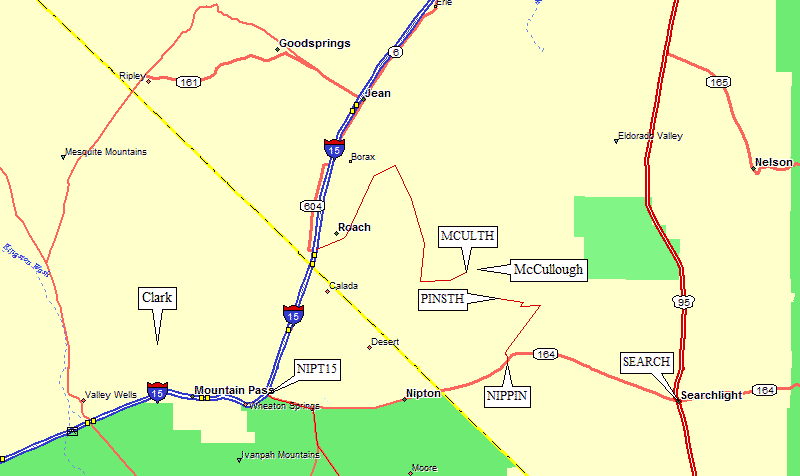
Hwy 164 through Nipton connects I-15 near the state line waypoint NIPT15) to Searchlight in Nevada (waypoint SEARCH). Just west of the highpoint of Hwy 164 is a dirt road (waypoint NIPPIN) leading to a powerline access road. The access road descends into upper Piute Valley to reach the Pine Spring drainage.
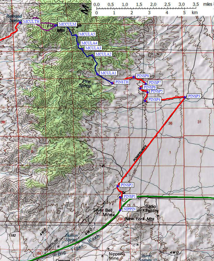
To reach the eastern approach to McCullough, go north from Hwy 164 at waypoint NIPPIN, which is about 13 miles from Searchlight or 18 miles from I-15. Turn right (northeast) onto the powerline road about 1 mile from the pavement (waypoint PINSP3), and go mostly downhill for another 4 miles. Turn left (west) at waypoint PINSP3, and jog north after 1.4 miles before continuing west to the trailhead at waypoint PINSTH, which is a total of 8 miles from the pavement of Hwy 164.
Eastern approach map:
For climbing details from the west, see this 2009 trip report.
There are a couple of casinos and a roller coaster just on the Nevada side where I-15 crosses the California-Nevada border. Various maps call this crowded and crass place Roach, Primm, and Stateline. All the stores, filling stations, restaurants, hotels, and everything else you can see appear to be owned by one conglomerate. Buffalo Bill's parking lot might be a good place to meet and/or leave cars since it's huge and there's lots of traffic 24 hours/day. Rooms are cheap (decent rooms were $29 for two beds in 2009), meals are lousy (a poorly prepared buffet was $12), gas is expensive, people are crazed and inconsiderate (to the extent they were driving sideways between rows of gas pumps to cut in line). I guess it's the Casino closest to LA.
| We found the DPS Guide's instructions did not match development around Primm. The green lines near the freeway on the topo map is a GPS track log from all the dead ends we drove! If you go on the wrong side of the casino, you'll see all sorts of private property do not enter signs, and you may end up on a restricted road to a power station. The DPS Guide's mention of going through a parking area led us to dirt race tracks, etc. The route described below does NOT go past any signs limiting entry. That doesn't mean it's not on private land, but it does mean you have plausible deniability about trespassing. If new signs have posted, proceed past them at your own risk! |
Exit I-15 at Primm Blvd, just north of the CA-NV border, where you'll see the big landmark roller coaster behind Buffalo Bill's Casino. Head toward that casino, then turn north (left) on Las Vegas Blvd (waypoint PRIMNV). Now on the frontage road north between the casino and the freeway, you'll go past their parking lot and under a monorail (waypoint BUFALO) as you go past the casino. DO NOT go north all the way to the end of this paved road that parallels the freeway! It becomes a dirt road which goes NE and dead ends at a canal and railroad track in the middle of (dry) Roach Lake.
You want to turn right (east) 100 yards before the pavement ends (waypoint MCUL01, about 0.7 mi from the freeway) at an unmarked intersection with a dirt road that runs between two high voltage powerlines. There are many powerlines here, and more will join and cross your approximate route later, but these are two closely spaced powerlines that have identical towers. I'd recommend a GPS!
The correct dirt road is the only one we found which can cross the railroad tracks (at waypoint MCUL02, 2 mi from the fwy) with a nice ramp and a stop sign. Continue NE on a good dirt road, staying between the two parallel powerlines until a good intersection going left (waypoint MCUL03, 3.2 mi from the fwy). There is a junction before this that may also work, but turning NW here takes you 0.1 miles to a road fork underneath an overlapping complex of crossing powerlines (waypoint MCUL04, 3.3 mi from the fwy). You could probably light a bulb here without wires attached! Note this junction, and take the LEFT fork on the way out! On the way in, bear right (northeast) following a different set of powerlines than you followed from the freeway.
The drive around the Lucy Gray Mountains (see below for the final approach to the trailhead):
NOTE: Green tracks were mistakes. Don't do those! The red line is the best route.
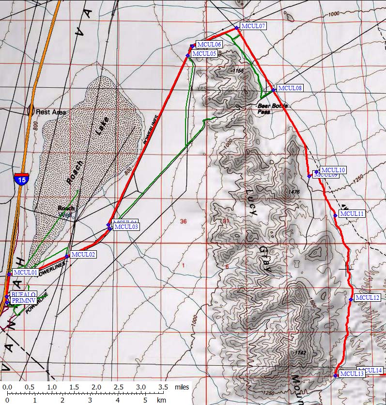
NOTE: If you go straight at MCUL03, following the green line on the topo map, you will go toward Beer Bottle Pass. We encountered huge ruts and scraped bottom repeatedly in a Jeep. Fearing for the vehicle, we turned around where the track log ends, and scraped our way north on a very bad hillside traverse to the powerline road you SHOULD be on (at waypoint MCUL05). The sides of the ruts are too steep and the roadbed is too rocky to do this safely unless you are in a monster truck. Beer Bottle Pass appears to be impassable!! The route below is basically the alternate route mentioned (but not described) in the DPS Guide.
Go straight along the powerline, northeast on the red GPS track log, between Roach Lake (dry) and the Lucy Gray Mountains. As you approach the mountains to your right (waypoint MCUL05, 7.5 mi from the fwy) you may see several side roads. Ignore them. Go straight until the powerline bends to the right (waypoint MCUL06, 7.8 mi from the fwy) and follow it around the end of the range until you hit a good road going southeast (waypoint MCUL07, 8.8 mi from the fwy). Don't turn too soon! The green lines here all work and are fairly good roads, but the red line is way better.
Once you turn south on the east side of the Lucy Gray Mtns, you are no longer following a powerline. Go straight across a really excellent powerline road (waypoint MCUL08, 10.5 mi from the fwy). This appears to be the road that goes over Beer Bottle Pass (Lucy must have been a heavy drinker) and turns into the nasty rocky rutted thing we had to give up on ascending. Don't be fooled when going back - Beer Bottle Pass is impassable. The road you're on continues southeast and eventually bends south as it climbs and stays near the base of the range.
There is a dogleg at waypoints MCUL09 and MCUL10 (12.6 and 12.8 mi from the fwy), near an old water tank and corrals and a cattle guard. Stay on the obvious road and resume going southeast, now in a wash that was once buldozed to form a road. The berms capture sand, and that really deep sand forms huge ruts with a risk of high-centering even in a Jeep. We had some trouble keeping our speed up, and would definitely have spun out without 4WD. Eventually you'll climb out of the deep sand and onto gray gravel, cresting a rise (waypoint MCUL12, 16 mi from the fwy) before dropping back into deep mushy sand on the other side. It's easier going down than up. Remember you have to come back!
Enlarged map from the Wilderness Area sign to the trailhead and peak:
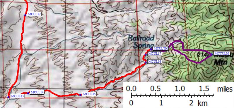
On your left (east) there will be a South McCullough Wilderness Area sign (waypoint MCUL13, 17.9 mi from the fwy). If you go just slightly past the sign you'll see a corral, which might have running (non-potable) water at times. Before the corral, right behind the sign, there is a track that turns uphill in a wash. It's not a road anymore, it's just a track in a narrow gravel wash... but it's actually better driving than the approach road before the sign! This part probably changes annually, or at least whenever there's a heavy rain. (The GPS track log often diverges slightly from the 4WD road shown on the USGS map.)
At waypoint MCUL14 (18.3 mi from the fwy) there is a fork you need to pay attention to only on the way out, when you'll stay right. At waypoint MCUL17 (21.4 mi from the fwy) the wash is completely blocked by boulder. You can drive up on the left, then cross and go up on right, then drop back into the wash... or you can just park and walk the wash. This is only about a tenth mile from the absolute end of the road, and if you drive all the way to the end you'll actually have to drop a bit to begin the climb. I'd recommend parking down at MCUL17 to avoid scratches on your vehicle. (You will get some further down, but they'll be heavier here!)
The road forks one last time, with the passable fork climbing out on the right (east) side of the wash where there's an old corrugated steel cabin (waypoint MCULTH, 21.5 miles from the freeway). It shows sign of recent use (easter eggs were still hidden there in 2009, and the ashes in the stove were fresh) but the wind and weather are slowly dismantling it. Don't bring more than 2 or 3 vehicles up here or you won't be able to turn around.
We spent 3 hours driving in (including exploration), just over 2 hours round trip to the peak, and 2 hours driving out. It's not just a climb, it's a fossile-fuel-burning adventure! Bring a shovel and some boards in case the sand gets your truck. Cell phones don't work once you leave Primm.
Useful Links: