Kelso Area Peaks
(Edgar, Mitchell, Old Dad, Granite)
Revised 18 Apr 2013 - please send updates to the webmaster
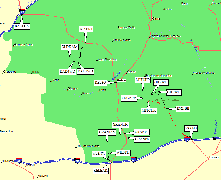
Kelbaker Road is easiest to find from Baker (waypoint BAKECA, an hour northeast from Barstow). From the only I-15 overpass, go south and then east on the only paved road. There are lots of restaurants and filling stations in Baker, but for all the places described below the next closest services are in Barstow. The Aiken Mine Rd turnoff for Old Dad (waypoint AIKENJ) isn't marked in any way, but you can't miss the railroad tracks and development at Kelso.
Finding Kelbaker Road from I-40 isn't much harder, but there's no town or anything else at the exit. Look for the exit from I-40 signed for Kelbaker Road (waypoint KELBAK). It's also about an hour east of Barstow, and an hour west of Needles. The sign there says Kelso is 22 miles north from the freeway, and has no services! Before Kelso, you'll go over the gentle Granite Pass (waypoint GRANPS) and by the turnoff to Granite Mtn N (waypoint GRANRJ).
Area Map: See below for detailed maps and descriptions of
- Granite Mtn N (#1)
- Edgar Peak and Mitchell Point
- Old Dad Mtn
For climbing details, see my 2009 trip report.
About 20 minutes east from Kelbaker Road on I-40, there is a well-signed
exit for Essex Road, Providence Mountains, and Mitchell Caverns (waypoint ESXJ40).
A sign here indicates 16 miles to Mitchell Caverns, where the ranger station is.
Almost 10 miles north of the
freeway, bear left at the Black Canyon turnoff (waypoint ESXJBC)
at the sign for Mitchell Caverns just before you cross under power lines.
Less than a mile from the powerlines (waypoint ESXJBB), there is a
green road sign for Ranch and Essex roads, and there is a wooden sign
saying Blair Brothers Ranch. If you're headed to the Mitchell Caverns trailhead and
ranger station (waypoint MITCHR, the DPS Guide Route A trailhead for Edgar),
stay left on pavement at waypoint ESXJBB.
For only Mitchell or to climb both peaks in a day (DPS Guide Routes B/C/D),
head for Gilroy Canyon by turning right 10.6 miles from I-40 on the dirt
Blair Brothers Ranch Road (ESXJBB).
I haven't been to the Mitchell Caverns trailhead for Edgar since 1982,
but it's paved all the way and well marked. See the waypoint file
comments and the overview map above for all that I know about that
trailhead. Updates are welcomed from someone who's been there recently!
The following directions are for the Bonanza King Mine and Gilroy Canyon
approach to Mitchell and/or Edgar.
From the Blair Brothers Ranch sign, follow the main dirt road
which has washboards and high berms on the sides. If you're brave,
driving 50 mph will smooth out the washboards! 4.8 miles from where
you left the pavement, 15.4 miles from the freeway, there is a
black-and-white sign on a tall metal pole (waypoint BBRJBM)
that says "Blair Ranch Private" to the right and
"Bonanza King Mine" to the left. The good road
is, of course, the private one. Passenger cars should park near
this sign - I made it about a quarter mile further, but without
high clearance that's about it.
The Bonanza King Mine road (left or northwest turn at waypoint BBRJBM)
appears to be the DPS Guide's alternate approach to the stone cabin ruins.
I don't think there's any reason to go there! Many trip reports moan
about the horrible climbing on their Route D, so why go there? Mostly
because it's hard to get a key for the approach from Mitchell Caverns
to Routes B and C... but I found an alternate approach that gets you
to the B/C trailhead withOUT a key. (On the other hand, if you want to
do it the hard way, those waypoints are at the end of the route.)
From the sign on a tall pole (waypoint BBRJBM) take the bad
road northwest toward the Bonanza King Mine. Passenger cars can
pull off at waypoint GIL2WD before the road enters a wash and
requires high clearance. In 2009 2WD trucks with high clearance
could get all the way to the end of the road (GIL4WD,
only 2 miles and about 400' higher) but it goes through a number of washes that
might change yearly. Oddly enough, I saw cattle grazing in this
seemingly barren desert!
To approach Mitchell and Edgar via Gilroy Canyon, I recommend
leaving the Bonanza King Mine road (either walking or driving)
at waypoint GILCNJ, where a faint track leads south. There are
no signs indicating you can't drive here, and there were fresh
tire tracks in 2009. I met some ranch hands near my car, and
they looked amused that a city slicker would be here. Walk level
on a road that's not shown on the map, bearing left at GILCN1,
until you intersect the road which IS shown at waypoint GILCN2.
Go across the better road, staying straight until the track bends
west in a wash around waypoint GILCN3.
There is a padlocked gate and a barbed wire fence at
waypoint GIL4WD, which is as far as 4WD vehicles can drive.
A sign on the ground said State Park Property but did not
prohibit entry. There's no way around the gate, but it's
high enough above the ground to easily go under. There is
plenty of room for parking as the vegetation is sparse. This gate
is 2 miles and 400' from the passenger car trailhead I've
marked, and it's another 0.8 miles and 400' from the trailhead
described by the DPS (OLD4WD). You don't need a key or permission
to drive here! I had dinner at the car, and walked up the road
while the sun set for a bivy in Gilroy Canyon, a good way to
get both Edgar and Mitchell even on short fall days.
Beyond the gate, continue west on an increasingly faint track
until you join the road the DPS Guide describes (waypoint GILCN4).
Mark this spot so you don't miss the left turn on the way out!
No one has driven between GIL4WD and GILCN4 in a long time.
The sometimes-accessible DPS Guide trailhead for Gilroy Canyon
is where the road ends (waypoint OLD4WD) and a trail drops into
the wash. Route C up Mitchell or Route B up Edgar start here,
and they can be combined in a reasonable day by running the
ridge between the peaks.
Winding Stair Cave is near OLD4WD, but I've been told it has
a locked door and you need Ranger permission to go exploring.
This is Granite Mtn #1 in the DPS Guide, and called
Granite Mtn North on the Desert Peaks page.
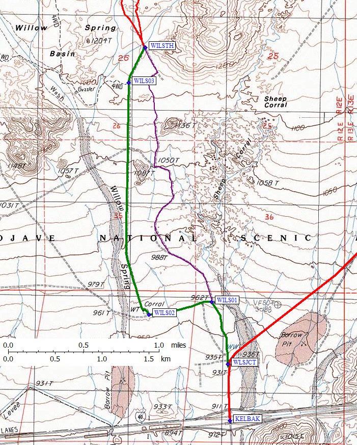
Southern Approach from I-15: From the Kelbaker Road exit of I-40
(waypoint KELBAK), go north 0.3 miles to the
Willow Spring junction (waypoint WLSJCT).
map of the southern approach trailhead area, see below for the eastern approach
Southern Approach (tracks, waypoints, and text by Matt Hengst): Leave the paved Kelbaker Road,
heading north where it turns notheast at waypoint WLSJCT.
Most all of the roads seem to work and I didn't see anything I couldn't
have gotten the Rav4 over with no problems. I took different roads
going in and out but the one running straight south (the green line)
was a little quicker. The Willow Spring trailhead is at the wilderness
boundary (waypoint WILSTH). Granite stats from
there were 7.4 miles and 3000' according to my Garmin but that included
a small detour to check the Granite Plateau (waypoint GRANPT)
and climb Granite Pinnacle (waypoint GRANPN).
map of the eastern approach trailhead area, see above for the southern approach
For climbing details for the eastern approach, see my 2009 trip report.
Eastern Approach from I-15: From the Kelbaker Road exit of I-40
(waypoint KELBAK), go north about 8 miles to Granite Pass
(waypoint GRANPS) where you'll drive over a
cattle guard. Continue north 1.8 miles from the cattle guard to the
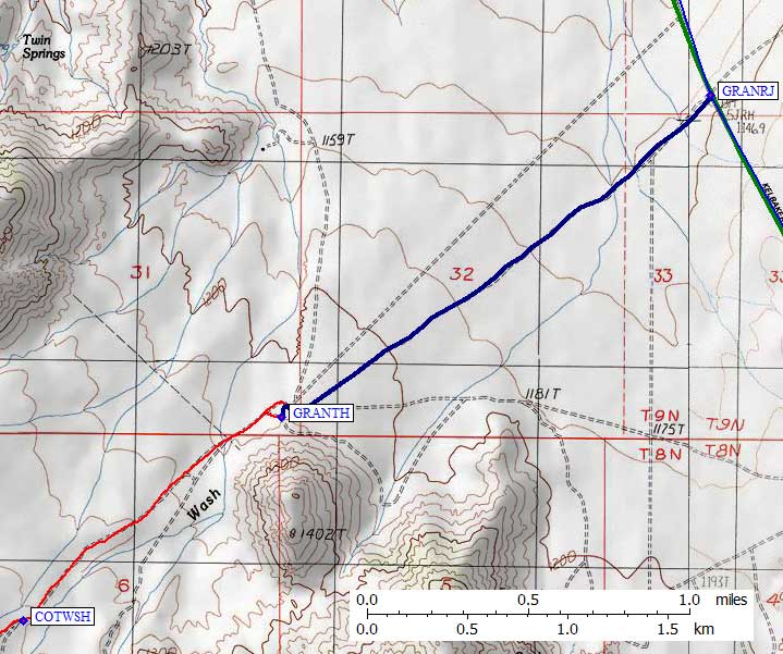
Granite Mtn turnoff (waypoint GRANRJ).
Eastern Approach from I-40 (Baker): From the Baker exit of I-15 (waypoint BAKECA), drive about 34 miles
south to Kelso. From the railroad tracks in Kelso, continue 12.6 miles
south to the Granite Mtn turnoff (waypoint GRANRJ).
Eastern Approach Trailhead: (may be closed) The Granite Mountain road (from waypoint GRANRJ to GRANTH) has no
sign, no evidence of a turn, and is a little tiny road that drops
through a grader ditch but is OK for passenger cars. A quarter mile
north from GRANRJ on Kelbaker Road is another unmarked and equally
small dirt road that might be an alternative if the road on the map
is washed out or closed. The two roads converge right at the trailhead,
but I've only driven on the one shown as a blue line on the map.
There are no clearance or traction problems for passenger cars,
but it's narrow with no place to meet another vehicle.
There are junctions shown on the map, and other junctions
you'll see on the ground... ignore them and go straight southwest
from the pavement (waypoint GRANRJ) to the staked end of the road
(waypoint GRANTH). The picnic table mentioned in the DPS Guide
seems not to exist.
Within a few yards of road's end, two or three other dirt roads
converge from various directions and there are various parking
areas. Be sure to keep track of exactly which road you came in on!
From the road's end, on the way out you will first take the right
fork, and then just about 50 yards later take the left (which
I didn't notice on the way in).
From the parking area (GRANTH) there are two separate dirt
tracks that drop west into the wash. Take either of them
and follow an old 4WD road (on foot) southwest to the peak.
For climbing details, see my 2009 trip report.
Essex Road from I-40 to Edgar Peak and Mitchell Point - GPS Routes MITCHELL TO EDGAR
and EDGAR ROUTE A, EDGAR ROUTE B
and MITCHELL ROUTE C, MITCHELL ROUTE D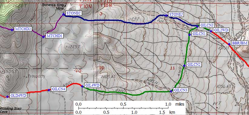
Granite Mtn N (#1) - GPS Routes GRANITE MTN N and
KELBAKER RD
The OTHER Granite Mtn is a few miles south.
The eastern approach to Granite may be closed or require permission
to enter an ecological study area.
Old Dad Mtn - GPS Routes OLD DAD and OLD DAD WASH and KELBAKER RD
|
19.5 miles east on Kelbaker Road from the overpass in Baker (waypoint BAKECA)
there is an unmarked dirt road called Aiken Mine Road, on which you turn south
(waypoint AIKENJ) for the Old Dad trailhead. If you're coming from I-40,
the turnoff (waypoint AIKENJ) is 37 miles from the freeway (waypoint KELBAK)
and 15 miles north of Kelso (waypoint KELSO).
There is no road sign of any kind for this one-land good dirt road, and it leaves the pavement where the paved road is straight. Don't turn on the other nearby unmarked road (waypoint NOTAIK) which intersects Kelbaker in a corner 0.4 miles SE from AIKENJ. Drive southwest on Aiken Mine Rd (if you're going due south you're on the wrong road). 1.7 miles from the pavement (waypoint AIKENJ) there is a T intersection (waypoint ODADR1) where you turn right (west). The road goes west briefly, then turns south and drops into a canyon. The map shows intersections that don't seem to exist (waypoint ODADR2) and doesn't show some that do exist (waypoint ODADR3). Keep straight on the main road as it bends southeast 3.9 miles from the pavement (just before waypoint ODADR3). Here the road parallels some high voltage power lines. As is often the case with power lines there are multiple roads that (at one time) must have all gone to the same place. |
From Kelbaker Road to the summit, see details map below: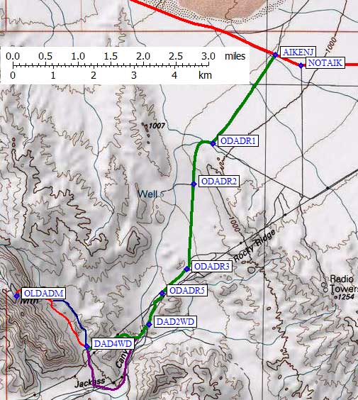
|
4.3 miles from the pavement (waypoint ODADR4) there is a major junction where you can stay right and drive in a sandy wash or stay left and climb onto a more solid road under the power lines. The high road (green line) is fine for passenger cars, I haven't driven the sandy road (purple line) but Matt Hengst said the soft sand was OK with his Rav4. The same choice (right for sandy or left for solid) happens again 4.4 miles from the pavement (waypoint ODADR5). Again I stayed left under the power lines.
Jackass Canyon details map, see map above for remainder of dirt road:
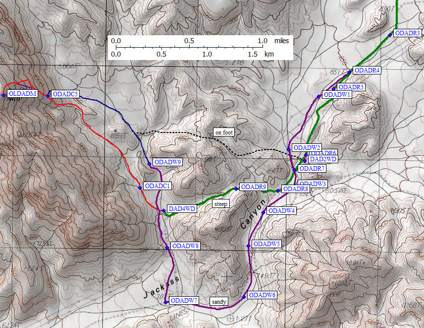
5 miles (only 15 minutes in my car) from the pavement (waypoint ODADR5) is a crucial junction. If you stay left here, on the solid road, you'll reach an overgrown washout in a few hundred yards. I'm calling this the 2WD trailhead (waypoint DAD2WD) because it's as close as you can get without true 4WD. This spur would be a great place for a large group to park and camp.
If you avoid the 2WD trailhead spur (green line) and turn right into the wash (purple line) after waypoint ODADR5 be prepared for deep and endless sand. The 4WD tracks here showed signs of all four wheels spinning as vehicles drove DOWN the wash, and you have to come back UP the wash to get out. It's not a short stretch and there's no solid ground on which to turn around. You don't need high clearance to drive on, but you do need great traction in the soft sand.
The roads on the ground don't quite match those shown on the map, and the BEST roads beyond here don't match the DPS Guide either. Drive or walk southwest into the wash (waypoint ODADR7) and follow the right-most road around Point 847.
Due south of Point 847 there is a junction where you turn right and go over a small saddle (waypoint ODADR8, 5.3 miles from the pavement). You can instead continue south in the wash as per the DPS GUide (purple line on my map, which Matt Hengst drove but I have not done). I'd suggest NOT staying in the soft sandy wash any longer than you have to! Matt Hengst reports that he didn't see the (green-line) road in 2013, and if you have a light 4WD (like his Rav4) or wide tires there's no problem continuing south in the wash (waypoint ODADW4) shown as a purple line that stays in Jackass Canyon and turns north near waypoint ODADW7. Matt reports that this northerly section is just a wash and not a road, so be prepared to hunt around for the best route depending on what happened with the latest seasonal storm.
If you're staying on the green line, turn right and climb out of the wash at waypoint ODADR8 5.3 miles from the pavement. This is a bladed but loose gravel road that is fairly steep but showed evidence of vehicle traffic. Walk or drive over the pass (waypoint ODADR9, 5.6 miles from the pavement) and drop to the Old Dad approach canyon. The road over this final pass is loose gravel but had been recently graded so there were no clearance issues in 2009. A Range Rover driver I talked to did both ways, and said he was "swimming" in the sand of the wash but had no trouble with the gravel.
The Old Dad 4WD trailhead (waypoint DAD4WD, 6.2 miles from the pavement) is a somewhat arbitrary place to stop driving. Matt continued north to waypoint ODADW9 where he found a good car camp spot. I think it's better to start walking from waypoint DAD4WD up the left side of the drainage toward the peak, but the road sort of continues north and there are no signs saying you can't drive further.
One final thought: It's 1.2 miles from the 2WD trailhead to the 4WD trailhead, and with a climb this short (another 1.5 miles to the summit) either trailhead is close enough for an easy half-day climb... so don't risk the sand if you have any concerns about getting stuck.
Useful Links: