Boundary, Montgomery, Dubois
Revised 11 Sep 2018 - please send updates to the webmaster
For details of a climb of Boundary/Montgomery, see this 2001 trip report
For details of a west-side climb of Dubois, see this 2010 trip report
Boundary Peak is the high point of Nevada and is in the same range as White Mountain. Sharing the ridge between these two is Montgomery, its higher neighbor, and Dubois. Dubois is between Montgomery and White in both latitude and elevation. The CA-NV state line goes between these Boundary and Montgomery, and since Boundary ends up in Nevada it ends up being that state's high point (making it more popular than Montgomery). White Mtn is a CA 14er and Dubois is on the DPS list.
There is a small cafe (not open early or late) in Benton, and a gas station where a credit card will get you gas all night (as of 2010).
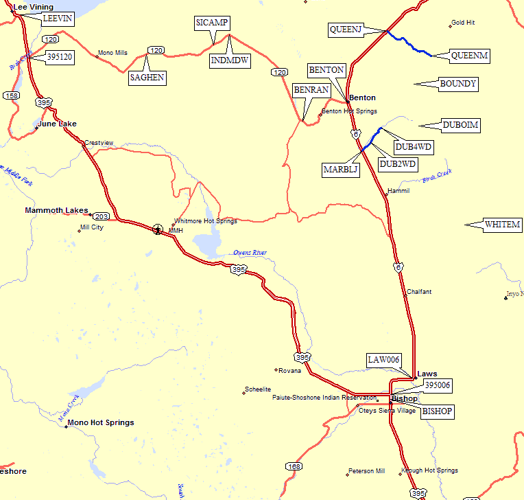
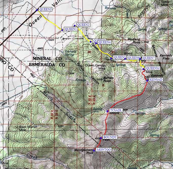
Drive to Benton (waypoint BENTON), then go North on Hwy 6 for almost 10 miles (crossing the Nevada state line in the process). On your left will be an old ranch with a sign 'JR' (Janie's Ranch). Accross from it is an unsigned dirt road, the Queen's Canyon Rd (waypoint QUEENJ).
Make a right turn (southeast at QUEENJ) and drive for 6.1 miles to waypoint QUEENM. At this point are remnants of the old Queen Mine, a mine shaft and two small hut like structures. There is also evidence of previous camping and several wire mesh cones on the ground. You can car-camp there and dayhike both Boundary Peak (13,143') and Montgomery Peak (13,441').
Everyone can drive to the Queen Mine (waypoint QUEENM), but there is brush which might scratch your paint. A Subaru had no problems in 2001 and several 2WD sedans had no problems in 2005. Those with high-clearance 4WDs can drive on up the road to Kennedy Saddle (waypoint KENSAD) saving about 0.7 mi and 700' of gain on foot. There is an abandoned trailhead sign at Kennedy Saddle, and a use trail leads all the way to the summit from here. (On the way down, be sure to turn left back to this saddle, or you'll walk down into Trail Canyon!)
The trail follows the south side of the ridge to Trail Canyon Saddle (waypoint TCSADL), then the west side of the ridge up to Boundary. Early season climbers (through June) may need ice axes, and continuing on to Montgomery involves steeper narrower ridges with a bit of low class 3.
GPS waypoints near the trailhead and camp, and the climb, are shown on the map below:
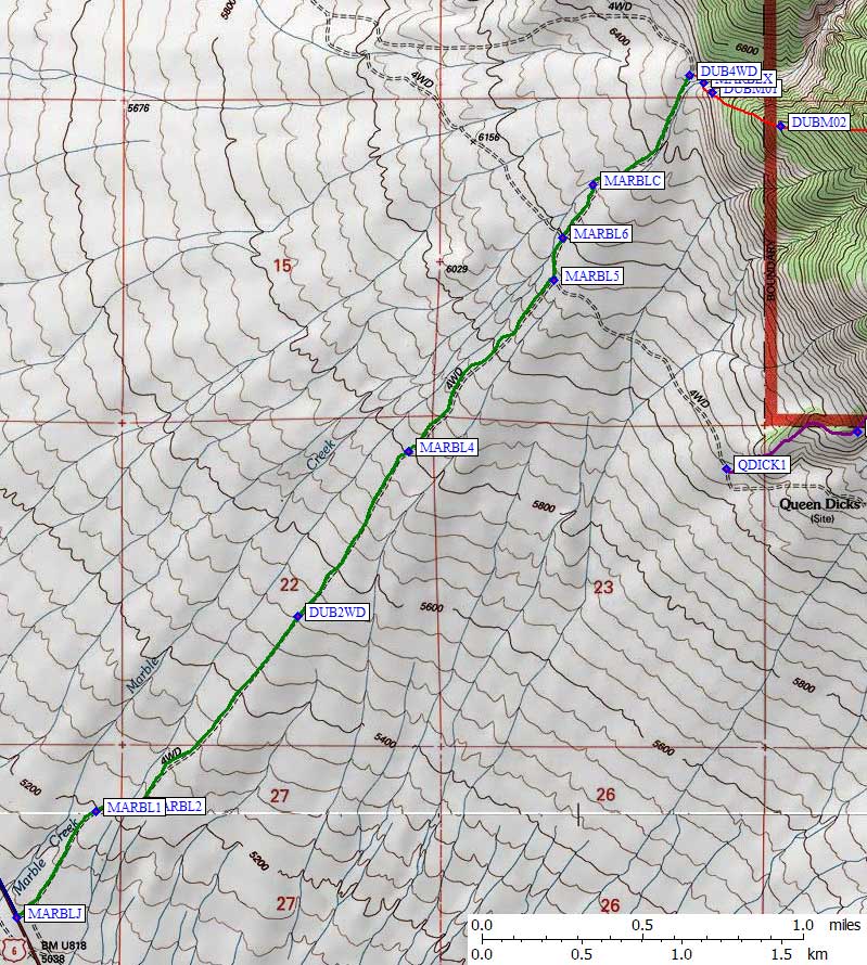
Drive 5.25 miles south of Benton or 29 miles north of Bishop on Hwy 6. Look for a small mine on the west side of Hwy 6 and an unlocked gate in a barbed wire fence (waypoint MARBLJ). There is no sign saying you can or can't enter, so head northeast on this dirt road at your own risk. In 2010 it was suitable for passenger cars but low-slung vehicles might not make it very far. The first part of the drive (green line below) is the same route used by Larry Tidball in 1993.
Take the right fork 0.4 miles from the pavement (waypoint MARBL1). Few if any of the roads here are on the map, and this junction is no exception. The green line on the map below is a GPS track log, with waypoints collected while driving. The road jogs across a small draw and then follows a rib parallel to Marble Creek.
There are increasing center clearance problems for passenger cars, so I left my car at a 4-way intersection 1.4 miles from Hwy 6 (waypoint DUB2WD). This cross-road is at 5500', and is not shown on the USGS map. Those with high clearance 2WD or 4WD can drive another 2.1 miles and 1000' higher! Continue northeast, still with no need for 4WD but high clearance required. Keep right/straight at the next fork (waypoint MARBL4, not shown on USGS maps).
This route diverges from the Tidball route at waypoint MARBL5, where the road to Queen Dicks turns southeast and the road up Marble Creek goes north. I chose to stay with Marble Creek because it's a shorter drive, the road goes higher, and the ridge is slightly less steep. Turn left at MARBL5, 2.75 miles from Hwy 6, and approach the main channel of Marble Creek. Take another right fork at waypoint MARBL6, less than 0.2 miles from the Queen Dick junction.
Those not wanting to scratch their paint will stop just before crossing Marble Creek (waypoint MARBLC, 3 miles from Hwy 6). The entire drive can be done with a reasonably high clearance 2WD (the creek is not deep) and the only brush is right in the creekbed. After crossing Marble Creek, the road again turns northeast, now following the west bank of the creek as both banks become steeper and higher.
You can drive 0.5 miles beyond the creek, to another junction which I'm calling the 4WD trailhead at 6500' (waypoint DUB4WD). An overgrown road heads up Marble Creek and quickly vanishes, while a better road goes noth before turning west and back down to Hwy 6 (I assume).
There is plenty of room to park and turn around at DUB4WD, and camping would not be bad (especially if the creek is running, as it was in mid-May 2010). Marble Creek turns east here, and you'll need to follow it before crossing to the south and gaining the ridge to Dubois. Look hard for the right place to cross (waypoint MARBLX) because the gully is impassable elsewhere due to thick brush, thorns, and steep banks. An alternative would be to park before crossing the creek, and walk cross-country staying east of the creek to gain the ridge.
After crossing the creek, look for an extravagent dead tree slightly downstream from the crossing. This is the best footing to gain the ridge. From here there are no level or downhill sections: it's all uphill on the same ridge until you cut across the final bowl to the summit of Dubois. For details of the climb from this trailhead, which I've never seen documented before, see my 2010 trip report.
GPS waypoints for the drive and near the trailhead are shown on the map below.
The green line is the drive from Hwy 6, the red line was how I climbed, the
purple line (I believe) represents Larry Tidball's route.
Useful Links: