A location to the nearest 100 meters is given by a six digit number. The first two digits are the eastward coordinate obtained from the top or bottom edge of the map and the third digit is the number of tenths of a kilometer to the east of the grid line. The fourth and fifth digits are the northward coordinate obtained from the left or right edge of the map and the sixth digit is the tenths of a km to the north of the grid line. For example Cartago Peak (012203) is about 200 meters (third digit) east of the north-south grid line that is numbered "01" on the map edge and about 300 meters (sixth digit) north of the east-west grid line that is numbered "20" on the map.
A location can be given to a precision of 10 meters by using an eight digit number where the third and fourth digits and the seventh and eighth digits give the fraction of a km to one percent. For example, Cartago Peak is the highest rock pile out of several nearby; its location to a precision of 10 meters is 01152033.
A memory aid for the order of the digits is "read right up", i.e. eastward then northward.
Latitude and Longitude (in degrees) are equivalent to UTMs as representations of location, but since the 'size' of a degree varies with location some people prefer UTMs when they are interpolating their position on a paper map. Some software mapping tools cannot read or write UTMs, so the data on Climber.Org is often available in both formats.
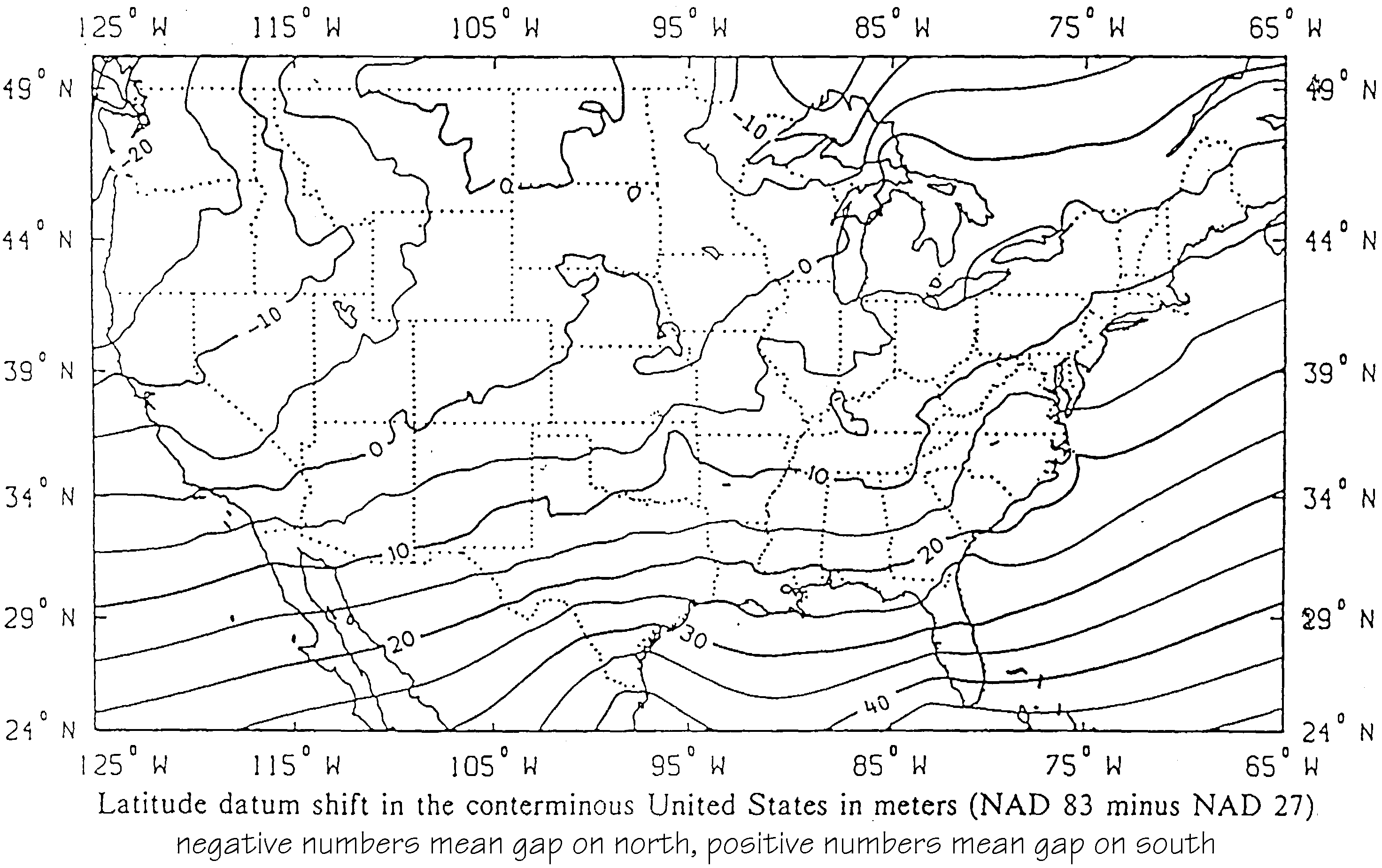
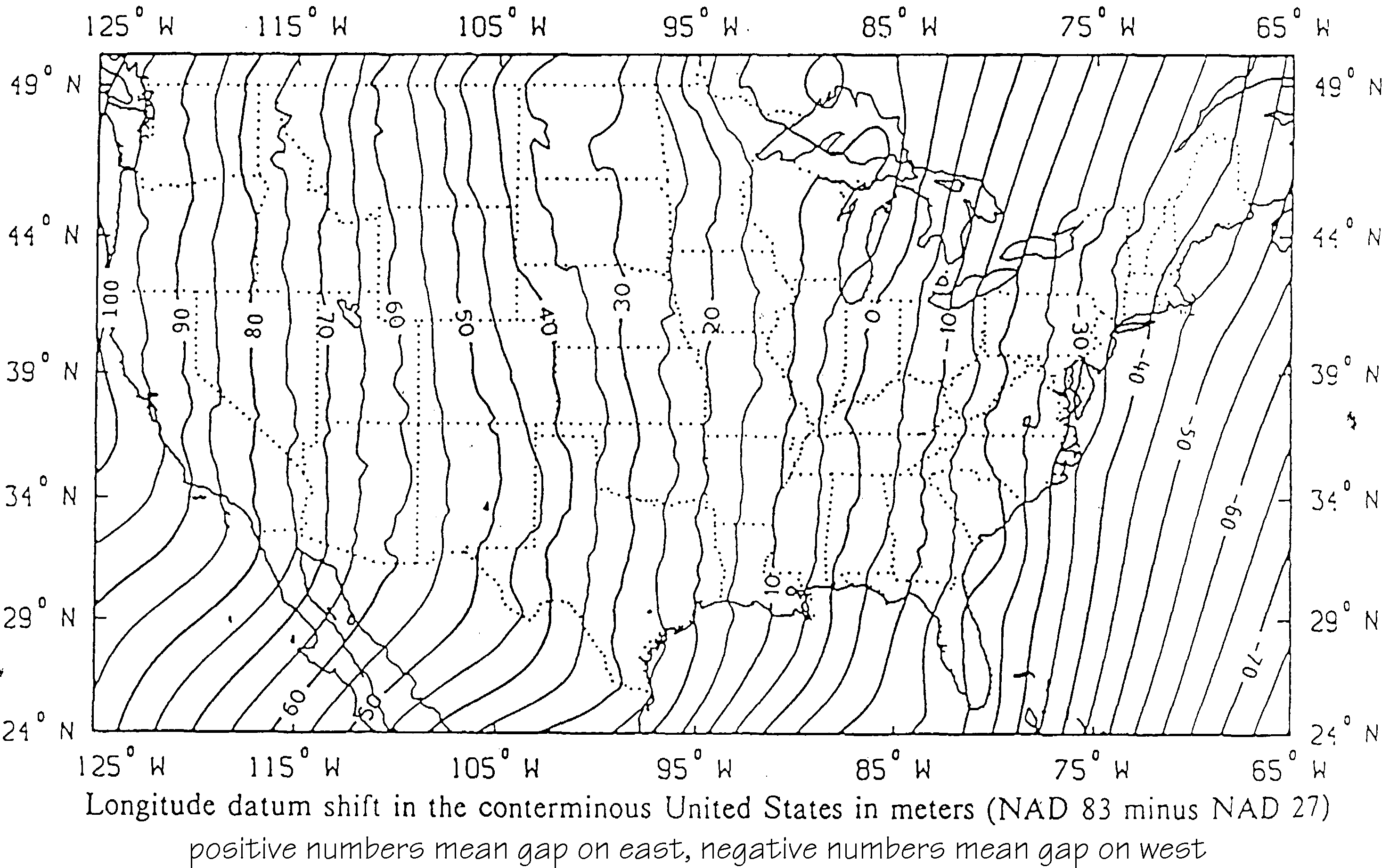
The amount of error between the datum used for drawing most UGSG maps (NAD27) and the datum used by GPS satellites (WGS84 is essentially the same as NAD83) varies with location. In places the difference between NAD27 and NAD83 datum is about a tenth of a mile or 100 meters. Authoritative details of how to convert between NAD27 and NAD83, including charts of how much difference there is between them as a function of location, can be found on the US National Geodetic Survey's NADCON page. Be sure your maps and/or software are using the same datum, or use software like Waypoint+ or TOPO!GPS to convert. Good data always has the datum specified with the waypoints! Assume nothing!
The following is a collection of information provided to me by the USGS at the Denver Federal Center and other inputs from listers. I will try to tell you what I found with my crash course on the datum goings on and the map plans the USGS has for us all.
Some of you may question the need for all this techy stuff but be assured that if you have been following the reports on GPS's and you are tempted to start using one then you should pay attention. These reports on "gear@climber.org" indicate exceptional X-Y-Z accuracy using a GPS now that the military is no longer dithering the time signal. The reason for this accuracy is that the GPS uses a real world datum not the spherical or elliptical or flat earth datum (this mystery explained at the website in item 1 below). This must not be ignored if you want to accurately locate yourself using the GPS. No big deal here in the US (since you can just use your map and compass)but if you are a world traveler then you have to know what is going on. The GPS most closely follows the North American Datum of 1983 (NAD83) but still requires inputs to adjust your GPS. So some of you may want to read on.
Example using item 3 above: Somewhere in/near TX, NAD27 grid 95 deg W/29 deg N becomes 95 00 .73000 W/29 00 .88154 N with the NAD83 grid. This is a difference of 27.141m N and 19.758m W or 33.571m total shift. (or 110+feet ). Check out N CA with over 100m shift.
So in conclusion, what do we need to do to use a GPS accurately?
To contact the USGS, phone 888 ASK-USGS (888 275 8747) or http://www.ask.usgs.gov (darn slow site)
Senne says "As it turns out, the distance from the geoid to earth center is much greater at Mt Chimborazo [Ecuador] than at Mt Everest ... if we use ''highest'' as the distance to earth center, Mt. Chimborazo is 1.36 miles higher than Mt. Everest. However, I doubt if Hillary would be interested in climbing Mt Chimborazo since the first to reach that summit was British mountaineer Edward Whymper in the year 1880."
Height above sea level (referenced to a non-spherical earth surface) or distance from the center of the earth? Does a couple thousand meters out of six million meters matter? Probably it does to those who have climbed Chimborazo and not Everest!