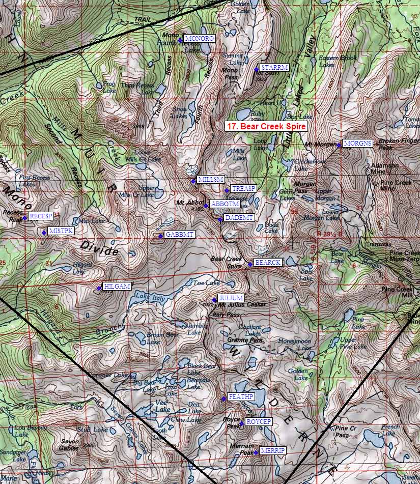
Map exported from TOPO! software, used with permission.
| Bear Creek Spire Area sorted numerically on Num column | ||||||||||||||
| The requested peak, Abbot Mt, is highlighted below. | ||||||||||||||
| click on these headings to sort by that column | click on these headings for more info | |||||||||||||
| Num | Peak Name (more links) | Waypoint | Elev | SPS | Class | Pics and Reports | UTM hint (map) | 7.5' Map | Register | |||||
| 17.1 | Merriam Peak | MERRIP | 13103 | 2 | 2 pics of MerriamPeak 9 reports on merriam | 436304 | Mt Hilgard | |||||||
| 17.2 | Royce Peak | ROYCEP | 13280+ | 2 | 1 pic of RoycePeak 7 reports on royce | 432314 | Mt Hilgard | |||||||
| 17.3 | Julius Caesar Mt | JULIUM | 13200+ | 2 | 1 pic of JuliusCaesarMt 6 reports on juliuscaesar | 423357 | Mt Hilgard | need | ||||||
| 17.4 | Hilgard Mt | HILGAM | 13361 | 2 | 1 pic of HilgardMt 4 reports on hilgard | 383362 | Mt Hilgard | |||||||
| 17.5 | Recess Peak | RECESP | 12813 | 2 | 1 pic of RecessPeak 3 reports on recess | 358387 | Mt Abbot | need | ||||||
| 17.6 | Gabb Mt | GABBMT | 13680+ | 2 | 3 pics of GabbMt 5 reports on gabb | 405380 | Mt Abbot | need | ||||||
| 17.7 | Bear Creek Spire | BEARCK | 13720+ | M | 3s4 | 3 pics of BearCreekSpire 14 reports on bear | 436370 | Mt Hilgard | need | |||||
| 17.8 | Dade Mt | DADEMT | 13600+ | 2 | 2 pics of DadeMt 12 reports on dade | 426385 | Mt Abbot | |||||||
| 17.9 | Abbot Mt | ABBOTM | 13704 | E | 3 | 1 pic of AbbotMt 6 reports on abbot | 421390 | Mt Abbot | need | |||||
| 17.10 | Mills Mt | MILLSM | 13451 | 3 | 1 pic of MillsMt 2 reports on mills | 416399 | Mt Abbot | |||||||
| 17.11 | Morgan S Mt | MORGNS | 13748 | 2 | 1 pic of MorganSMt 8 reports on morgan | 467410 | Mt Morgan | need | ||||||
| 17.12 | Starr Mt | STARRM | 12870 | X | 2 | 1 pic of StarrMt 11 reports on starr | 439437 | Mt Abbot | ||||||
| 17.13 | Mono Rock | MONORO | 11555 | X | 2 | 1 report on mono | 413448 | Mt Abbot | ||||||
| 17.14 | Treasure Peak | TREASP | 12920+ | X | 3 | 1 pic of TreasurePeak 1 report on treasure | 428395 | Mt Abbot | ||||||
| 17.15 | Mist Peak | MISTPK | 12680+ | X | 2 | 364382 | Mt Abbot | |||||||
| 17.16 | Feather Peak | FEATHP | 13240+ | X | 2s3 | 1 pic of FeatherPeak 4 reports on feather | 426323 | Mt Hilgard | need | |||||
NOTE: M = Mountaineers Peak, E = Emblem Peak, X = not on SPS List (in 'SPS' column)
^ = metric contours and elevations on 7.5' maps (in 7.5' map columns)
Name Mt => 'Mt' should be before peak 'Name' (ex: Rose Mt is Mount Rose, but sorted on 'Rose')
Name Mtn => 'Mtn' is after peak 'Name' as listed (ex: Muah Mtn is Muah Mountain)
Maps listed here are USGS 7.5 minute topo quads
Below are GPS waypoints, in Waypoint+ text format, suitable for downloading to a GPS or importing/viewing in TOPO! software. The comment field contains the exact peak name, as in the various lists of peaks, but may be truncated by your GPS. The waypoint names are all abbreviated to 6 characters. Note that peaks marked by 'X' in the table above are not on the SPS List.
The first set of data below has decimal degrees, with latitude and longitude after the 3rd and 4th comma. The second set of data shows full UTM zone, easting, and northing after the 3rd, 4th, and 5th commas. The "UTM Hint" in the table above represents the peak location to the nearest 100 meters, use the data below for more precision.
NAD83 datum, Latitude/Longitude in decimal degrees (UTM below).
Datum,North America 1983,GRS 80,0,-1.6E-7,0,0,0
RouteName,17,BEARCREEKSPIRE
RoutePoint,D,MERRIP,37.3090527,-118.7652981,08/28/2008,00:04:05,MERRIAM PEAK
RoutePoint,D,ROYCEP,37.3182153,-118.7708651,08/28/2008,00:04:05,ROYCE PEAK
RoutePoint,D,JULIUM,37.3567954,-118.7816407,08/28/2008,00:04:05,JULIUS CAESAR MT
RoutePoint,D,HILGAM,37.3605756,-118.8267350,08/28/2008,00:04:05,HILGARD MT
RoutePoint,D,RECESP,37.3824014,-118.8557110,08/28/2008,00:04:05,RECESS PEAK
RoutePoint,D,GABBMT,37.3766655,-118.8025700,08/28/2008,00:04:05,GABB MT
RoutePoint,D,BEARCK,37.3680367,-118.7675042,08/28/2008,00:04:05,BEAR CREEK SPIRE
RoutePoint,D,DADEMT,37.3819362,-118.7793178,08/28/2008,00:04:05,DADE MT
RoutePoint,D,ABBOTM,37.3863560,-118.7848313,08/28/2008,00:04:05,ABBOT MT
RoutePoint,D,MILLSM,37.3939822,-118.7899292,08/28/2008,00:04:05,MILLS MT
RoutePoint,D,MORGNS,37.4051573,-118.7329634,08/28/2008,00:04:05,MORGAN S MT
RoutePoint,D,STARRM,37.4289800,-118.7650999,08/28/2008,00:04:05,STARR MT
RoutePoint,D,MONORO,37.4380600,-118.7949599,08/28/2008,00:04:05,MONO ROCK
RoutePoint,D,TREASP,37.3910500,-118.7767900,08/28/2008,00:04:05,TREASURE PEAK
RoutePoint,D,MISTPK,37.3778100,-118.8481800,08/28/2008,00:04:05,MIST PEAK
RoutePoint,D,FEATHP,37.3259300,-118.7779700,08/28/2008,00:04:05,FEATHER PEAK
NAD27 datum, UTM Zone/East/North in decimal meters (degrees above).
Datum,North America 1927 mean,Clarke 1866 ,-69.4,-0.37264639,-8,160,176
RouteName,17,BEARCREEKSPIRE
RoutePoint,UTM,MERRIP,11,343642.7,4130419.8,08/28/2008,00:04:05,MERRIAM PEAK
RoutePoint,UTM,ROYCEP,11,343168.4,4131445.6,08/28/2008,00:04:05,ROYCE PEAK
RoutePoint,UTM,JULIUM,11,342294.3,4135744.2,08/28/2008,00:04:05,JULIUS CAESAR MT
RoutePoint,UTM,HILGAM,11,338308.5,4136239.9,08/28/2008,00:04:05,HILGARD MT
RoutePoint,UTM,RECESP,11,335789.8,4138711.6,08/28/2008,00:04:05,RECESS PEAK
RoutePoint,UTM,GABBMT,11,340482.8,4137984.0,08/28/2008,00:04:05,GABB MT
RoutePoint,UTM,BEARCK,11,343569.7,4136967.9,08/28/2008,00:04:05,BEAR CREEK SPIRE
RoutePoint,UTM,DADEMT,11,342552.7,4138529.8,08/28/2008,00:04:05,DADE MT
RoutePoint,UTM,ABBOTM,11,342073.8,4139029.4,08/28/2008,00:04:05,ABBOT MT
RoutePoint,UTM,MILLSM,11,341638.5,4139884.1,08/28/2008,00:04:05,MILLS MT
RoutePoint,UTM,MORGNS,11,346704.2,4141030.0,08/28/2008,00:04:05,MORGAN S MT
RoutePoint,UTM,STARRM,11,343909.3,4143725.9,08/28/2008,00:04:05,STARR MT
RoutePoint,UTM,MONORO,11,341286.4,4144783.2,08/28/2008,00:04:05,MONO ROCK
RoutePoint,UTM,TREASP,11,342796.0,4139536.0,08/28/2008,00:04:05,TREASURE PEAK
RoutePoint,UTM,MISTPK,11,336446.7,4138189.0,08/28/2008,00:04:05,MIST PEAK
RoutePoint,UTM,FEATHP,11,342554.9,4132313.4,08/28/2008,00:04:05,FEATHER PEAK