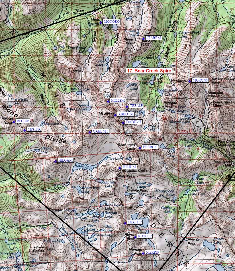
Sierra Peaks - Region 17
Bear Creek Spire Area
Generated on 21 Aug 2022 - see revision history - please send updates to the webmaster
|
Bear Creek Spire Area sorted numerically on Num column | ||||||||||||||
| Click on the peak name for similarly named peaks in a statewide peaks database. | ||||||||||||||
| click on these headings to sort by that column | click on these headings for more info | |||||||||||||
| Num | Peak Name (more links) | Waypoint | Elev | SPS | Class | Pics and Reports | UTM hint (map) | 7.5' USGS topo quad | Register | |||||
| 17.1 | Merriam Peak | MERRIP | 13103 | 2 | 2 pics of MerriamPeak 10 reports on merriam | 436304 | Mt Hilgard | |||||||
| 17.2 | Royce Peak | ROYCEP | 13280+ | 2 | 1 pic of RoycePeak 8 reports on royce | 432314 | Mt Hilgard | need | ||||||
| 17.3 | Julius Caesar Mt | JULIUM | 13200+ | 2 | 1 pic of JuliusCaesarMt 7 reports on juliuscaesar | 423357 | Mt Hilgard | need | ||||||
| 17.4 | Hilgard Mt | HILGAM | 13361 | 2 | 1 pic of HilgardMt 5 reports on hilgard | 383362 | Mt Hilgard | |||||||
| 17.5 | Recess Peak | RECESP | 12813 | 2 | 1 pic of RecessPeak 4 reports on recess | 358387 | Mt Abbot | need | ||||||
| 17.6 | Gabb Mt | GABBMT | 13680+ | 2 | 3 pics of GabbMt 6 reports on gabb | 405380 | Mt Abbot | need | ||||||
| 17.7 | Bear Creek Spire | BEARCK | 13720+ | M | 3s4 | 3 pics of BearCreekSpire 15 reports on bear | 436370 | Mt Hilgard | ||||||
| 17.8 | Dade Mt | DADEMT | 13600+ | 2 | 2 pics of DadeMt 13 reports on dade | 426385 | Mt Abbot | |||||||
| 17.9 | Abbot Mt | ABBOTM | 13704 | E | 3 | 1 pic of AbbotMt 7 reports on abbot | 421390 | Mt Abbot | need | |||||
| 17.10 | Mills Mt | MILLSM | 13451 | 3 | 1 pic of MillsMt 3 reports on mills | 416399 | Mt Abbot | |||||||
| 17.11 | Morgan S Mt | MORGNS | 13748 | 2 | 1 pic of MorganSMt 11 reports on morgan | 467410 | Mt Morgan | need | ||||||
| 17.12 | Starr Mt | STARRM | 12870 | X | 2 | 1 pic of StarrMt 12 reports on starr | 439437 | Mt Abbot | need | |||||
| 17.13 | Mono Rock | MONORO | 11555 | X | 2 | 2 reports on mono | 413448 | Mt Abbot | ||||||
| 17.14 | Treasure Peak | TREASP | 12920+ | X | 3 | 1 pic of TreasurePeak 1 report on treasure | 428395 | Mt Abbot | ||||||
| 17.15 | Mist Peak | MISTPK | 12680+ | X | 2 | 364382 | Mt Abbot | |||||||
| 17.16 | Feather Peak | FEATHP | 13240+ | X | 2s3 | 1 pic of FeatherPeak 4 reports on feather | 426323 | Mt Hilgard | need | |||||
NOTE: M = Mountaineers Peak, E = Emblem Peak, X = not on SPS List (in 'SPS' column)
      ^ = metric contours and elevations on 7.5' maps (in 7.5' map columns)
      Name Mt  => 'Mt' is before peak 'Name' (ex: Rose Mt is Mount Rose, but sorted on 'Rose')
      Name Mtn => 'Mtn' is after peak 'Name' as listed (ex: Muah Mtn is Muah Mountain)
The "UTM Hint" in the table above approximates the peak location to the nearest 100 meters.
Click here for info on Universal Transverse Mercator coordinates.
Useful Links: