Desert Peaks - Region 8
Arizona
Generated on 5 Aug 2021 - see revision history - please send updates to the webmaster
|
Arizona sorted numerically on Num column | ||||||||||||||
| Click on the peak name for similarly named peaks in a statewide peaks database. | ||||||||||||||
| click on these headings to sort by that column | click on these headings for more info | |||||||||||||
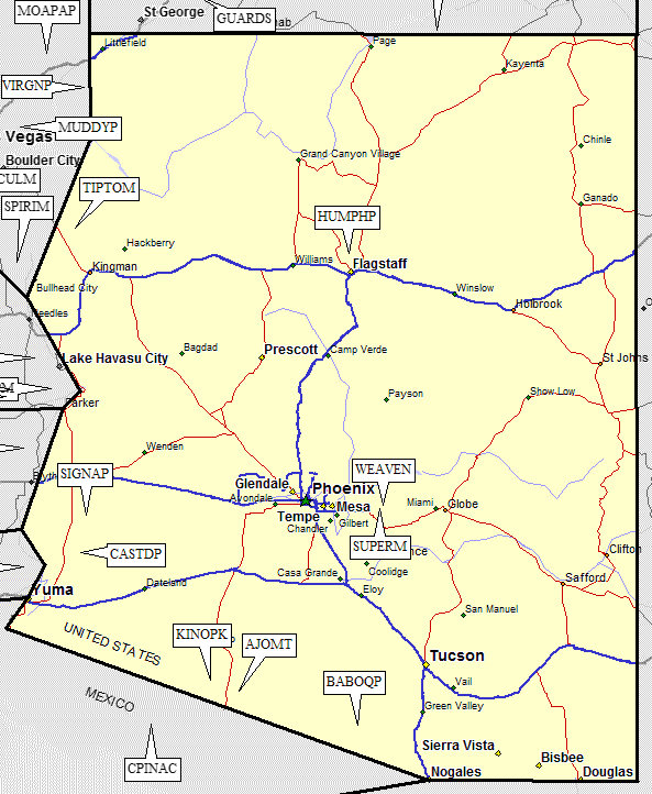
| Num | Peak Name (more links) | Waypoint | Elev | DPS | Class | Pics and Reports | UTM hint (map) | 7.5' USGS topo quad | Register | |||||
| 8.1 | Tipton Mt | TIPTOM | 7148 | 2 | 1 report on tipton | 546362 | Mt Tipton | |||||||
| 8.2 | Humphreys Pk | HUMPHP | 12633 | 1 | 3 reports on humphreys | 385115 | Humphreys Peak | |||||||
| 8.3 | Superstition Mtn | SUPERM | 5057 | 2 | 1 report on superstition | 628967 | Goldfield | |||||||
| 8.4 | Weavers Needle | WEAVEN | 4553 | 4 | 1 report on weavers | 656992 | Weavers Needle | |||||||
| 8.5 | Signal Pk | SIGNAP | 4877 | E | 2 | 1 report on signal | 715947 | Palm Canyon | ||||||
| Signal Pk is also called 'Kofa Peak' by the DPS. | ||||||||||||||
| 8.6 | Castle Dome Pk | CASTDP | 3788 | 3 | 1 report on castle | 667641 | Castle Dome Peak | |||||||
| 8.7 | Kino Pk | KINOPK | 3197 | 3 | 1 report on kino | 156541 | Kino Peak | |||||||
| marked as SUSPENDED, but DPS trip reports are still in place as of 2008 | ||||||||||||||
| 8.8 | Ajo Mt | AJOMT | 4808 | 2 | 1 report on ajo | 404445 | Mt Ajo | |||||||
| 8.9 | Baboquivari Pk | BABOQP | 7734 | 4 | 2 reports on baboquivari | 436150 | Baboquivari Peak | |||||||
NOTE: M = Mountaineers Peak, E = Emblem Peak, X = not on DPS List (in 'DPS' column)
      ^ = metric contours and elevations on 7.5' maps (in 7.5' map columns)
      Name Mt  => 'Mt' is before peak 'Name' (ex: Rose Mt is Mount Rose, but sorted on 'Rose')
      Name Mtn => 'Mtn' is after peak 'Name' as listed (ex: Muah Mtn is Muah Mountain)
The "UTM Hint" in the table above approximates the peak location to the nearest 100 meters.
Click here for info on Universal Transverse Mercator coordinates.
Useful Links: