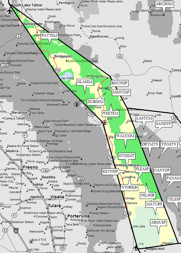
Desert Peaks - Region 1
Trans Sierra
Generated on 5 Aug 2021 - see revision history - please send updates to the webmaster
|
Trans Sierra sorted alphabetically on Waypoint column | ||||||||||||||
| Click on the peak name for similarly named peaks in a statewide peaks database. | ||||||||||||||
| click on these headings to sort by that column | click on these headings for more info | |||||||||||||
| Num | Peak Name (more links) | Waypoint | Elev | DPS | Class | Pics and Reports | UTM hint (map) | 7.5' USGS topo quad | Register | |||||
| 1.14 | Argus Pk | ARGUSP | 6562 | 1 | 1 report on argus | 598675 | Trona West | |||||||
| NO LEGAL ACCESS! See NAWS memo. DPS trip reports have been removed as of 2008 Argus Pk is within the Naval Weapons Center. The approach from the east may be closed at any time. | ||||||||||||||
| 1.3 | Boundary Pk | BOUNDP | 13140 | 2 | 812894 | Boundary Peak | ||||||||
| 1.5 | Dubois Mt | DUBOIM | 13559 | 2 | 2 reports on dubois | 818824 | Boundary Peak | |||||||
| 1.2 | Glass Mtn Ridge | GLASSM | 11140 | 1 | 3 reports on glass | 500811 | Glass Mtn | |||||||
| Glass Mtn Ridge's summit is higher than, and about 0.6 mi SSE of, the point labeled 'Glass Mountain' on the topo. | ||||||||||||||
| 1.8 | Inyo Mt | INYOMT | 10975 | E | 2 | 4 reports on inyo | 121658 | New York Butte | ||||||
| 1.9 | Keynot Pk | KEYNOP | 11101 | 2 | 4 reports on keynot | 141627 | New York Butte | |||||||
| 1.13 | Maturango Pk | MATURP | 8839 | 2 | 555972 | Maturango Peak | ||||||||
| NO LEGAL ACCESS! See NAWS memo. DPS trip reports have been removed as of 2008 Maturango Pk is within the Naval Weapons Center. The approach from the east may be closed at any time. | ||||||||||||||
| 1.4 | Montgomery Pk | MONTGP | 13441 | E | 2 | 807885 | Boundary Peak | |||||||
| 1.12 | Nelson Range | NELSOR | 7696 | 2 | 3 reports on nelson | 414457 | Nelson Range | |||||||
| 1.10 | New York Butte | NYORKB | 10668 | 1 | 3 reports on newyork | 167560 | New York Butte | |||||||
| 1.1 | Patterson Mt | PATTEM | 11673 | 1 | 989566 | Mt Patterson | ||||||||
| 1.11 | Pleasant Pt | PLEASP | 9690 | 1 | 2 reports on pleasant | 273474 | Cerro Gordo Peak | |||||||
| Pleasant Pt's summit is NNW of Cerro Gordo Mine; permission to drive, park, or hike in the area should be obtained from the caretaker at the mine. | ||||||||||||||
| 1.7 | Waucoba Mtn | WAUCOM | 11123 | 2 | 104976 | Waucoba Mtn | ||||||||
| 1.6 | White Mtn Pk | WHITEM | 14246 | 1 | 10 reports on white | 893658 | White Mtn Peak | |||||||
NOTE: M = Mountaineers Peak, E = Emblem Peak, X = not on DPS List (in 'DPS' column)
      ^ = metric contours and elevations on 7.5' maps (in 7.5' map columns)
      Name Mt  => 'Mt' is before peak 'Name' (ex: Rose Mt is Mount Rose, but sorted on 'Rose')
      Name Mtn => 'Mtn' is after peak 'Name' as listed (ex: Muah Mtn is Muah Mountain)
The "UTM Hint" in the table above approximates the peak location to the nearest 100 meters.
Click here for info on Universal Transverse Mercator coordinates.
Useful Links: