Pinto Peak
|
There are three approaches to this peak that I know of, and I did two of them.
The shortest is from Towne Pass, but that would be the same windy view
I had the day before (see below for Daryn's description of that route).
The longest is from Emigrant Pass, but it's on a ridge
the whole way and I didn't want wind again. I think the most scenic route is
up an un-named drainage from Emigrant Canyon. See the
trailhead page
for driving waypoints and trailheads for all three approaches.
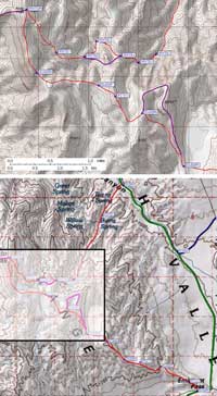
Just after dawn, I parked at waypoint EMIPIN, which I had scouted the day before. There is no road sign, but the right place to park is marked by a mound of dirt and a wilderness stake. This former road is closed and almost overgrown, but still worth finding to avoid the light scrub brush. From the parking area (only large enough for 2-3 cars) the road goes north and then turns east into the drainage. It's really easy walking up to the old mine near Burns Spring (which features several old passenger cars and a shack near waypoint PINTE1). At waypoint PINTE2 I took the right fork of the wash at large orange-brown cleaver. Any time after than you can climb onto the rib right (north) of the drainage to avoid the steepening bowl where wash ends. Traverse between two saddles (PINTE4-5) and pick any route over open terrain to Pinto Peak (waypoint PINTOP, 7508'). It took me about 4 hours to summit, 4.9 miles from the car. | |
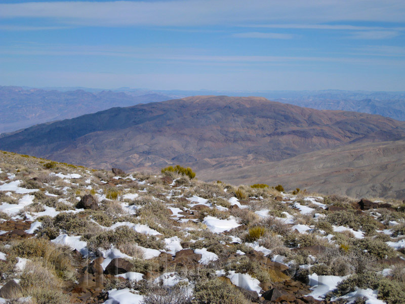
Tucki isn't very high but it's very wide (as seen from Pinto Peak)
Imagine my surprise when I found a jeep trail at the summit of Pinto! It is faint in places, but I followed it all the way down to Emigrant Pass. One major deviation from the old road is at waypoint EMIGP6, where I cut down an easy slope while the road went around the drainage and came down a rib. The walking is easy, and there's no real route finding, but it's 6.8 mi from the peak to the pass. Then I walked another 6.3 miles back to the car on pavement. There was plenty of traffic on the highway, but no one stopped and it only took a couple of mostly downhill hours.
This night was worse at Emigrant Campground, with a ranger coming to check out an illegal fire, 4 cars and 4 tents per site, and an electric guitar starting up at 9pm! My mistake, coming here on a holiday weekend when GenX hippies were reuniting their outer selves. The next day I scouted Mosaic and drove to Skidoo, but first I had to drive all the way to Furnace Creek for premium gas (Stovepipe has only regular, and my car's computer will rat me out to the dealer if I use low octane). After all the wind and snow, Furnace Creek had very nice weather! I enjoyed a shower and long lunch with a cold beer under a shade tree. On the way to Skidoo, however, the sky went gray and the temperature dropped. It looked like rain. The road to Skidoo is well marked, and suitable for all vehicles. I noted the "Day Use Only" sign when I left the pavement (at EMISKI), and followed my GPS to the sign marking the old site of Skidoo. There is a road junction and turnaround loop at the sign, but it's a long walk back to the "Wilderness Area" sign blocking the old side road toward Tucki (waypoing SKIDTH). There is no wide spot, no parking, and graded berms on both sides. Look for the roadblock with a sign that says "Wilderness Restoration, foot and horse traffic only". I put two wheels up on the berm and hoped no yahoos would crash into my car. Then I put up a tent on the nice flat gravel and hoped no one really cared about crashing for the night (as opposed to developing a campsite). Matt, Anne, and Jen showed up in his Rav4 around 10pm, following a GPS waypoint I had sent them from my sat phone. 4am came early, Jen was far away, and Matt and Anne spent a cold night in the vehicle due to forgotten sleeping bags... but we all piled in my car and raced around to Mosaic Canyon in time for a pre-dawn start. | ||
![]() Download the Waypoint+ data below as a GPX file for your GPS.
Download the Waypoint+ data below as a GPX file for your GPS.
Datum,North America 1983,GRS 80,0,-1.6E-7,0,0,0
RouteName,9 ,PANAMINT TOWNE POINT
RoutePoint,D,TOWNPS, 36.4001564980,-117.2799781561,01/30/2010,02:26:42,TOWNE PASS 5000
RoutePoint,D,PANB01, 36.4034899473,-117.2908799648,01/30/2010,02:27:03,
RoutePoint,D,PANB02, 36.4109300375,-117.2920900583,01/30/2010,02:27:24,
RoutePoint,D,PANB03, 36.4125599861,-117.2964199781,01/30/2010,02:27:41,
RoutePoint,D,PANB04, 36.4183900356,-117.2984700203,01/30/2010,02:27:52,
RoutePoint,D,PANB05, 36.4182100296,-117.3053400517,01/30/2010,02:28:21,
RoutePoint,D,PANB06, 36.4143400192,-117.3100999594,01/30/2010,02:28:27,
RoutePoint,D,TOWNEP, 36.4197900295,-117.3181699514,01/30/2010,02:28:35,TOWNE PT 7287
RoutePoint,D,PANB08, 36.4257999659,-117.3164800406,01/30/2010,02:29:07,
RoutePoint,D,PANB09, 36.4325499535,-117.3164000511,01/30/2010,02:29:26,
RoutePoint,D,PANB10, 36.4376300573,-117.3221000433,01/30/2010,02:29:36,
RoutePoint,D,PT6390, 36.4315199852,-117.3354599476,01/30/2010,02:29:46,
RoutePoint,D,PANB12, 36.4246100187,-117.3427499533,01/30/2010,02:30:14,
RoutePoint,D,PANAMB, 36.4339100122,-117.3560099602,01/26/2008,10:29:40,2_5 PANAMINT BUTTE 6584
RouteName,10 ,PINTO TRAVERSE
RoutePoint,D,EMIPIN, 36.4100342989,-117.1752756834,02/15/2012,16:26:46,EMIGRANT CYN PINTO WASH
RoutePoint,D,PINTE1, 36.3990999460,-117.1846200228,03/22/2012,05:06:04,ROAD ENDS OLD MINE DEBRIS
RoutePoint,D,PINTE2, 36.3756799698,-117.1976000071,02/15/2012,16:30:16,ORANGE CLEAVER
RoutePoint,D,PINTE3, 36.3741626740,-117.2015675306,03/22/2012,05:26:14,LEAVE WASH
RoutePoint,D,PINTE4, 36.3753700256,-117.2055200338,03/22/2012,05:28:25,SADDLE STAY LOW
RoutePoint,D,PINTE5, 36.3780299425,-117.2108999491,02/15/2012,16:30:35,SADDLE TRAVERSE
RoutePoint,D,PINTE6, 36.3752079010,-117.2136754990,03/22/2012,05:30:54,
RoutePoint,D,PINTE7, 36.3759800196,-117.2198599577,02/15/2012,16:30:52,
RoutePoint,D,PINTOP, 36.3836899996,-117.2264900208,01/26/2012,17:48:02,PINTO PK 7508
RoutePoint,D,PINTW3, 36.3827199936,-117.2413599491,02/15/2012,16:31:52,
RoutePoint,D,PINTW2, 36.3949999809,-117.2502800226,02/15/2012,16:32:07,
RoutePoint,D,PINTW1, 36.4034800529,-117.2626700401,02/15/2012,16:32:26,
RoutePoint,D,TOWNPS, 36.4001564980,-117.2799781561,01/30/2010,02:26:42,TOWNE PASS 5000
RouteName,11 ,PINTO EMIGRANT
RoutePoint,D,EMIGPS, 36.3347599506,-117.1417900324,03/23/2010,22:52:18,EMIGRANT PASS
RoutePoint,D,PT5522, 36.3381799459,-117.1456199884,02/15/2012,16:38:58,
RoutePoint,D,EMIGP2, 36.3437367678,-117.1581923962,02/15/2012,16:40:03,
RoutePoint,D,PT6172, 36.3453862667,-117.1674798727,02/15/2012,16:39:40,
RoutePoint,D,EMIGP4, 36.3463171721,-117.1748332977,02/15/2012,16:40:30,
RoutePoint,D,PT6660, 36.3529478312,-117.1824889183,03/22/2012,03:56:00,POINT 6660
RoutePoint,D,EMIGP5, 36.3555608988,-117.1914943457,02/15/2012,16:40:56,
RoutePoint,D,EMIGP6, 36.3650822639,-117.2007616758,02/15/2012,16:41:26,
RoutePoint,D,PT7073, 36.3681362867,-117.2067451477,03/22/2012,05:32:20,POINT 7073
RoutePoint,D,EMIGP7, 36.3701021671,-117.2104449272,02/15/2012,16:42:16,
RoutePoint,D,EMIGP8, 36.3723498583,-117.2242120504,02/15/2012,16:42:50,
RoutePoint,D,PINTOP, 36.3836899996,-117.2264900208,01/26/2012,17:48:02,PINTO PK 7508
RouteName,12 ,SKIDOO ROAD
RoutePoint,D,SKIDOO, 36.4345200062,-117.1380699873,01/26/2012,17:49:00,SKIDOO GHOST TOWN SIGN 5700
RoutePoint,D,SKIDTH, 36.4348599911,-117.1224399805,01/06/2007,17:33:04,SKIDOO TH FOR TUCKI 5600
RoutePoint,D,SKIRD4, 36.4307081699,-117.1115531921,02/15/2012,16:27:57,
RoutePoint,D,SKIRD3, 36.4225947857,-117.1052551270,02/15/2012,16:27:46,
RoutePoint,D,SKIRD2, 36.4032888412,-117.1044073105,02/15/2012,16:27:38,
RoutePoint,D,SKIRD1, 36.3977169991,-117.1336569786,02/15/2012,16:27:29,
RoutePoint,D,EMISKI, 36.3857424259,-117.1509160995,02/15/2012,16:27:14,EMIGRANT CYN SKIDOO JCT
RouteName,13 ,TUCKI TRAVERSE
RoutePoint,D,MOSJCT, 36.6045389175,-117.1484483480,01/26/2012,19:10:39,STOVEPIPE WELLS MOSAIC CYN
RoutePoint,D,MOSAIC, 36.5720208883,-117.1446132660,01/26/2012,18:01:43,MOSAIC CYN PARKING 1000
RoutePoint,D,MOSCN1, 36.5603115559,-117.1314768791,02/15/2012,16:08:44,LEAVE MOSAIC CYN
RoutePoint,D,MOSCN2, 36.5572910309,-117.1335207224,02/15/2012,16:09:18,
RoutePoint,D,MOSCN3, 36.5499730110,-117.1327183247,02/15/2012,16:09:33,
RoutePoint,D,MOSCN4, 36.5434899330,-117.1358370781,02/15/2012,16:09:48,
RoutePoint,D,MOSCN5, 36.5352100134,-117.1352800131,02/15/2012,16:10:02,SADDLE 4800
RoutePoint,D,ODROCK, 36.5315400362,-117.1320199966,03/22/2012,16:57:11,SADDLE WITH ODD ROCKS
RoutePoint,D,MOSCN6, 36.5292700529,-117.1239999533,02/15/2012,16:11:19,SADDLE TRAVERSE 5500
RoutePoint,D,MOSCN7, 36.5201508999,-117.1202433109,03/22/2012,17:06:31,
RoutePoint,D,PT6670, 36.5034400225,-117.1195900440,02/15/2012,16:12:12,
RoutePoint,D,TUCKIM, 36.4998199940,-117.1302000284,01/26/2008,10:29:40,2_6 TUCKI MTN 6726
RoutePoint,D,SKIDO7, 36.4922699928,-117.1311399937,02/15/2012,16:19:26,
RoutePoint,D,SKIDO6, 36.4841699600,-117.1234600544,02/15/2012,16:18:31,
RoutePoint,D,PT5730, 36.4756150246,-117.1146963835,02/15/2012,16:17:51,
RoutePoint,D,MARTIN, 36.4704999924,-117.1160900593,02/15/2012,16:24:27,OLD MARTIN CROSSING CABIN 5100
RoutePoint,D,MARLUK, 36.4646799564,-117.1112400293,01/06/2007,17:33:04,RIDGE BTWN MARTIN AND LUCKY 5400
RoutePoint,D,SKIDO5, 36.4630600214,-117.1000499725,02/15/2012,16:17:10,SADDLE IF ON ROAD 5200
RoutePoint,D,SKIDO4, 36.4560799599,-117.0979299545,02/15/2012,16:16:41,ROAD JCT
RoutePoint,D,LUCKYW, 36.4544800520,-117.1158200502,02/15/2012,16:16:19,LUCKY WASH 4800
RoutePoint,D,SKIDO3, 36.4463160038,-117.1153813601,03/22/2012,17:15:55,TOP OF RIB
RoutePoint,D,SKIDO2, 36.4425760508,-117.1185644865,02/15/2012,16:14:28,
RoutePoint,D,SKIDO1, 36.4376112223,-117.1229966879,02/15/2012,16:13:58,SADDLE
RoutePoint,D,SKIDTH, 36.4348599911,-117.1224399805,01/06/2007,17:33:04,SKIDOO TH FOR TUCKI 5600