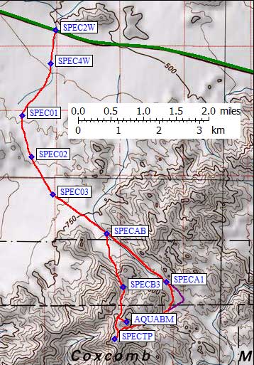
The DPS Guide describes a 4WD trailhead half a mile in, but the Spectre trailhead road is closed 100' from the pavement: fenced, gated, and closed forever. Just park on the side of highway 62 at SPEC2W. (See the trailhead page for maps and waypoints of both the drive and the climb.) It's hard to tell you're walking on a road as you head south from the pavement because sand is washing over and erasing the old roadbed.
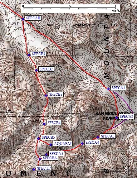
I left the pavement at 6am, following footprints on the sandy route. An hour later I was 3 miles in but had only climbed 600'. I left the old road about 3.5 miles from the pavement, angling across a plain to the Route B saddle, but if I had it to do over I'd stay on the road until the second wash on the right (waypoint SPECAB, 3.8 miles from the pavement, where Route A and B diverge). It's probably worth the extra mileage to stay on the better footing longer.
|
see the trailhead page
for these waypoints and driving maps/waypoints
|
|
The approach to this saddle (above waypoint SPECB1) is UGLY - lots of boulders, very steep, and some granite faces that had to be worked around. Around 3.1k the options narrow and I worked my around a cleaver (waypoint SPECB2) taking ledges on the right of the cleaver up to 3.2k. I stayed on the left side of the drainage as the terrain got easier up to a nice sandy saddle (waypoint SPECB3).
This is tortured terrain! Don't be fooled by the USGS map contours - the heavy lines are only 50m apart, instead of the 100m spacing you see on other maps. From the SPECB3 saddle the route goes southeast down to a drainage junction then climbs back up to the southwest. I cut the corner and climbed up the left (east) side as this branch of the drainage split again near the only pine tree I'd seen so far (SPECB4). The tree line here is around 4k, and even though the trees were sparse it was nice to climb into a pine forest.
Dyadic and Spectre from Aqua - only Aqua has an official name but Spectre is higher
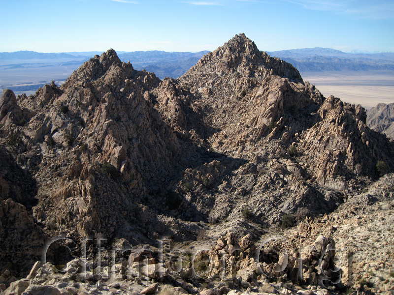
I went over the west shoulder of Aqua at 4.1k (waypoint SPECB5) and decided I had time to climb it. There is a register at the benchmark on Aqua (waypoint AQUABM) and the map contours show it as the high point of the Coxcomb Mountains, but the map is wrong! Aqua is labeled on the USGS map as 1346m=4415', while Spectre's top contour is 1300m=4264'. My altimeter read 65' higher on Spectre than it had a few minutes earlier on Aqua, making Spectre Point 4279'. Looks like they forgot a few contours on Spectre, just like they forgot to give it a name (Spectre Point is a name assigned by the DPS).
I spent some time on Aqua, which has a very nice 360 degree view with interesting rock formations all around. Aqua and Spectre are made of different rock than anything else in the area. I dropped to the saddle north of Spectre, then traversed down and over to where Route A and B converge (SPECBA). It's class 2-3 from here to the summit, maybe you could keep it strictly class 2 but I didn't. I went past a very nice tree, up thru a gap, then up a face on boulders and base rock. The line on the map is approximate because it's hard to draw the right line when the map contours are wrong!
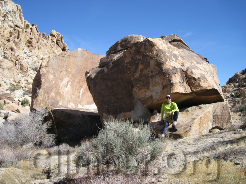
It took 4.5 hours to reach the summit of Spectre Point (waypoint SPECTP), and I stayed only half an hour because the view was actually better from Aqua. I went back down the same way. Somewhere near SPECA5 I went past a house-sized boulder that makes a great marker for the top of Route A. Route A is far, far easier than Route B!
Huge boulders that identify the top of Route A
It's best to stay on the south side, not in middle of the drainage, to the south and east of Aqua. There are no cliffs or waterfalls or forks, just boulder hopping and sand in a straight line. On the way up the "straight line" will keep you in the proper drainage around 3.5k (waypoint SPECA4). Below 3.3k (waypoint SPECA3) I stayed on the north side for better footing.
At 3k I started a level traverse to avoid dropping all the way to the canyon bottom as suggested by the DPS Guide. I had to climb up and down 20-30' through some side cut washes, but overall this was a shorter route with far less gain than dropping only to climb again. There is a small notch at 3k (waypoint SPECA2) that defines the corner of this shortcut, with a 50' drop on the north side of the notch, but good stable sand terrain made this fast walking until I rejoined Route A.
There is a broad sandy pass at 3k (waypoint SPECA1) where all the rocks are badly decomposing granite and erosion has created some interesting shapes. There was a use trail on a rib in the center of the drainage and by 2.9k I was walking in an easy but sandy wash. At 2.8k there is a section of boulders that can be bypassed on the south, and by 2.7k it was a 50' wide flat riverbed which could have been driven to back when that was legal.
I toyed with following another wash back to the highway, and while the rock shapes were more interesting the travel was slow as the canyon meandered between waterfalls. I ended up back at the road around 230pm, just over an 8 hour day. This surprised me, because I had heard Spectre was a really long day and I had done a loop and an extra summit, but it left me plenty of time to go get a shower and dinner in Twentynine Palms. I spent the night there, gave my WalMart shovel to the hotel clerk, cleaned up the Jeep, and flew home. (If you've been reading these reports in sequence, you may remember this trip started with Black Butte in a big storm...)