I had climbed Freel Peak (10881) from the town of Meyers many years ago, but our 12-hour winter dayhike didn't leave time to bag Jobs Peak (10633) or Jobs Sister (10823)... so I had to go back! Mid-December seemed like the best time for some reason, and of course I had to use a different route. See the bottom of the report for waypoints and maps, including an interactive map, and also see the freshly revised trailhead pages.
This time I drove up and down Hwy 89 between Meyers (where 50 meets 89) and Hope Valley (south of Luther Pass) trying to find some good place to park so I could follow the dirt road to Horse Meadow. No luck. There were plowed places, but they were either silent on whether you could park or strictly prohibited it (as with the Luther Pass parking area that is only a snowplow turnaround in winter). So I drove down to the Hope Valley parking lot and walked two thirds of a mile up the pavement to a Road Closed sign I had spotted. Waypoint WILLOW turns out to be a private road into a wildlife area. You can't park here since people with keys were driving through the gate, but it's a good way to get past all the willows of Willow Creek!
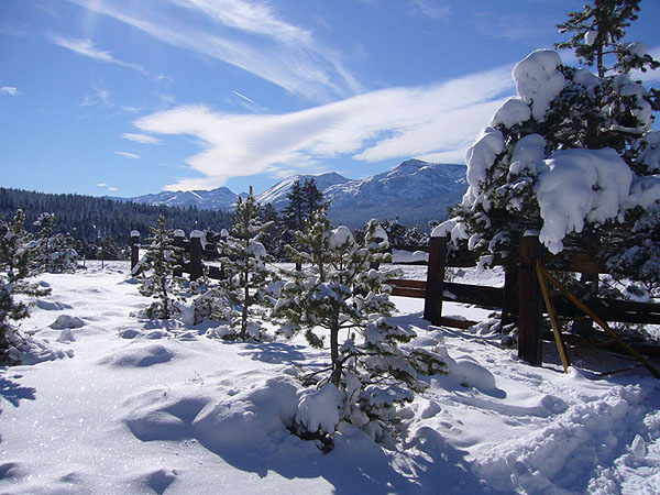
View from the Willow Creek trailhead:
I soon ran out of tracks, and had the whole valley to myself. There was less than 2' of snow near the highway, not enough to go cross-country but plenty of powder to make snowshoes necessary. The road junctions are hard to see on the topo maps, there are few if any signs, and it's easy to get disoriented in a valley full of trees. At the second significant junction (waypoint PACK02) I was up on a shoulder and could see Hope Valley again. At PACK03 I crossed Willow Creek to avoid private land that some unofficial-looking signs said would be ahead. By this point there was enough snow for XC travel, but I still scraped my snowshoes on the occasional rock or stump.
There's a trail somewhere on the slope I climbed, but I never saw it. I did catch part of a road, but going straight up the shoulder seemed faster. The snow was getting deeper and it was getting to be dusk since I didn't leave the car until 1pm. I crested the ridge at waypoint PACK05 and edged around a meadow to the Horse Meadow road. The snowmobiles were all gone by now, but their packed track (above PACK06) made it much easier to tromp on after dark. I never saw the spot where the trail is supposed to come in (waypoint WILHOR) but there was an untravelled intersection up to Armstrong Pass at waypoint WILARM.
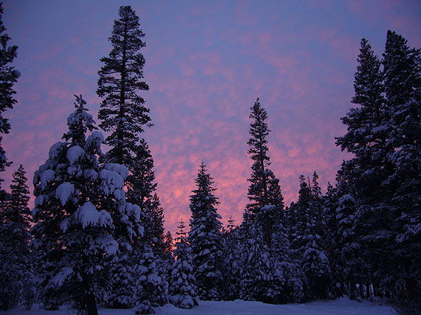
Time for a flashlight!
I camped just beyond the intersection below Horse Meadow (waypoint HORSEM), spending about 5 hours getting here from the car. In the dark, I didn't realize I had gotten so far, and thought at the time I was near the base of Armstrong Pass! It was in the single digits overnight, and the morning snow crunched like hardpack even though it was fluffy powder. Brushing a tree unleashed an avalanche suitable for a Jack London story since there had been no wind since the snow. Worried about climbing steeply in the powder, I angled onto the south ridge of Jobs Peak.
This is a frustrating peak because you never see the summit. Never! At the first false summit (waypoint CLIMB2) I came out into harsh wind. I had been watching spindrift on Freel all morning, now I was engulfed in it. Powder-laden branches on stately trees were replaced with rhime ice on stubby pines. (But at least I had a cell phone signal and could update my 'flight plan'.) I went over the bump at waypoint CLIMB3 just so I could see the peak. Foiled again. No way to tell from this angle which outcropping was the one.
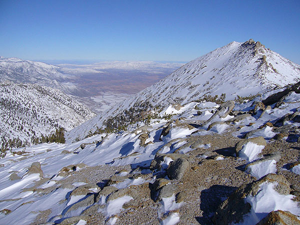
The final saddle and Jobs Peak:
From here the travel got way harder. Hip-deep drifts alternated with bare dirt and boulder-hopping, as I tried to stay left (west) of the ridge from the final saddle to the summit. Bad choice. I came back on the east side, which was mostly blown clear. The high point of Jobs Peak is not the named point - the named point is the north end of a triangle, the high point is the east end. Nice view down into the Nevada high desert! I took a 360-degree panorama, flipped through the stack of summit registers in an old USPS mailbox, and tried to find a spot out of the wind for lunch. Jobs Peak was one cold place. At noon the temp was in the teens and there was a strong wind on top of that.
There appear to be lots of use trails across the gravel slope leading to the saddle with Jobs Sister. The wind was howling, spindrift was flowing in a ground blizzard, clouds were headed toward me from the northeast, but it was still early afternoon and I placed a bet I could get to Jobs Sister and back to camp before dark.
Jobs Sister had some surprises for me! She's one hard, cold, 'lady'. The snow near the saddle was packed, but as soon as the angle steepened it turned to powder too loose to wallow up even at an angle. I traversed north to a scree slope that had blown clear and frozen, and carried my snowshoes while doing some damage to my plastic boots. Closer to the summit, just when I thought I was home free, there was a band of drifts too soft to climb without snowshoes and too thin in places to reliably sink snowshoes into. Crawling worked, but wasn't very dignified.
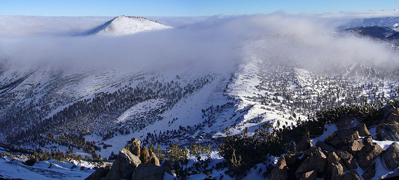
Clouds streaming around Jobs Peak, from Jobs Sister:
Did I mention the clouds? By the time I was on top of Jobs Sister (grin) Jobs Peak was gone! Clouds streaming over the ridge on both sides of me were feeding little spindrift tornados that made it impossible to face away from the wind. I abandoned my vague hope of bagging Freel and headed down a long straight descent into Horse Meadow. I sure am glad I didn't climb this way. Deeper powder, a steeper slope, thin spots, and some crust made going down fast but challenging.
I overshot a bit, thinking it was better to be too high as I neared camp than too low (and trapped in the bushes). The USGS map shows a large clearing near waypoint CLIMB7, but it's willows and brush - better to stay further northeast and cross Willow Creek higher. Still, I got to camp by 5pm and any winter climb that takes 10 hours without needing a headlamp is a good one.
That night the wind never stopped. Much of the snow was knocked off the trees, but it was too cold to actually snow. A heavy 'frost fall' along with the wind meant super-fine spindrift came in through any little vent hole in my bivy bag. Even my fine bug mesh didn't keep it out. Oh, well, it was my last night and I had extra clothes so a slightly damp bag was no problem.
The clouds which had filled the valley vanished with the morning sun, and I walked out in beautiful (but cold) conditions. To check out the other trailhead, I stayed on the dirt road all the way to Hwy 89 (at waypoint HORSEJ). I tossed my pack behind a tree and walked 2 miles back to Hope Valley at almost 4mph in plastic boots. I was really ready to be wearing dry cotton again!
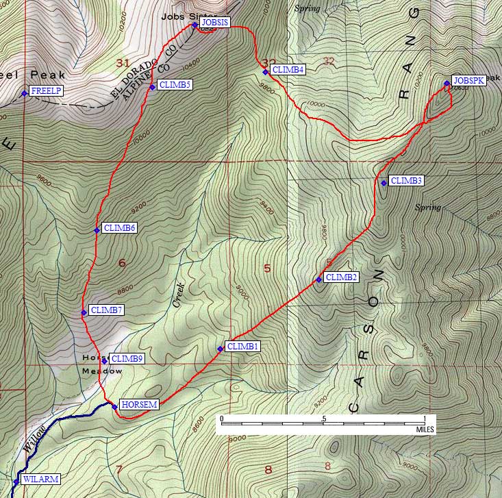
Climbing Route:
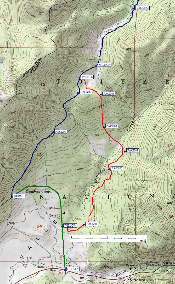
Backpacking Route:
![]() Download the Waypoint+ data below as a GPX file for your GPS.
Download the Waypoint+ data below as a GPX file for your GPS.
Datum,North America 1983,GRS 80,0,-1.6E-7,0,0,0
RouteName,1 ,BACKPACK
RoutePoint,D,HOPVLY, 38.7763500214,-119.9188699722,05/12/2000,16:45:55,SR88 JCT SR89 IN HOPE VALLEY
RoutePoint,D,WILLOW, 38.7852100134,-119.9196300507,12/14/2007,20:33:17,HWY 89 JCT WILLOW CK TRAIL 7100
RoutePoint,D,PACK01, 38.7855900526,-119.9138300419,12/14/2007,20:33:17,
RoutePoint,D,PACK02, 38.7969199419,-119.9072599411,12/14/2007,20:33:18,
RoutePoint,D,PACK03, 38.8005800247,-119.9031200409,12/14/2007,20:33:18,
RoutePoint,D,PACK04, 38.8055000305,-119.9086799622,12/14/2007,20:33:18,
RoutePoint,D,PACK05, 38.8121500015,-119.9093799591,12/14/2007,20:33:18,
RoutePoint,D,PACK06, 38.8155900240,-119.9150400162,12/14/2007,20:33:18,
RoutePoint,D,WILHOR, 38.8180799484,-119.9105600119,12/14/2007,20:33:18,WILLOW CK TR JCT HORSE MDW RD 8200
RoutePoint,D,WILARM, 38.8296999931,-119.9007600546,12/14/2007,20:33:18,WILLOW CK JCT ARMSTRONG PASS 8300
RoutePoint,D,HORSEM, 38.8350100517,-119.8917299509,12/14/2007,20:33:20,HORSE MDW 8400
RoutePoint,D,WILARM, 38.8296999931,-119.9007600546,12/14/2007,20:33:18,WILLOW CK JCT ARMSTRONG PASS 8300
RoutePoint,D,WILHOR, 38.8180799484,-119.9105600119,12/14/2007,20:33:18,WILLOW CK TR JCT HORSE MDW RD 8200
RoutePoint,D,PACK06, 38.8155900240,-119.9150400162,12/14/2007,20:33:18,
RoutePoint,D,PACK07, 38.8125000000,-119.9154100418,12/14/2007,20:33:20,
RoutePoint,D,PACK08, 38.8043800592,-119.9220000505,12/14/2007,20:33:20,
RoutePoint,D,HORSEJ, 38.7912199497,-119.9327800274,12/14/2007,20:33:20,HWY 89 JCT HORSE MDW RD 7400
RouteName,2 ,CLIMBING
RoutePoint,D,HORSEM, 38.8350100517,-119.8917299509,12/14/2007,20:33:20,HORSE MDW 8400
RoutePoint,D,CLIMB1, 38.8392000198,-119.8821400404,12/14/2007,20:33:19,
RoutePoint,D,CLIMB2, 38.8441300392,-119.8731199503,12/14/2007,20:33:19,
RoutePoint,D,CLIMB3, 38.8509900570,-119.8671300411,12/14/2007,20:33:19,
RoutePoint,D,JOBSPK, 38.8581700325,-119.8613699675,12/17/2007,18:23:48,
RoutePoint,D,CLIMB4, 38.8589560986,-119.8780149221,12/18/2007,21:44:54,
RoutePoint,D,JOBSIS, 38.8622800112,-119.8844599724,12/17/2007,18:23:48,
RoutePoint,D,FREELP, 38.8574299812,-119.9000300169,12/03/2007,22:36:56,FREEL PK 10881
RoutePoint,D,CLIMB5, 38.8578799963,-119.8882800341,12/14/2007,20:33:19,
RoutePoint,D,CLIMB6, 38.8476300240,-119.8933600187,12/14/2007,20:33:19,
RoutePoint,D,CLIMB7, 38.8418006897,-119.8945999146,12/14/2007,20:33:19,
RoutePoint,D,CLIMB9, 38.8382999897,-119.8926800489,12/14/2007,20:33:20,
RoutePoint,D,HORSEM, 38.8350100517,-119.8917299509,12/14/2007,20:33:20,HORSE MDW 8400