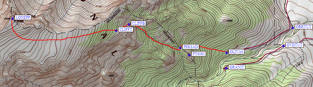
Secor's book says the Tuttle Creek (southeast) approach to Lone Pine Peak starts on Granite View Drive. This is not a good choice. You have a steep, loose, deep, brushy stream crossing between you and the climb (from waypoint GRANIT on the map below). Instead, take Olivas Ranch Road to reach the same elevation on the correct side of Tuttle Creek (more details are on that trailhead page). Passenger cars can drive to 6400' (the broad corner at waypoint ORRTUT), high clearance 4WDs can easily drive to the end of the road at 7000' (waypoint OLIVAS).
It's virtually impossible to get lost on this route. From the parking area (waypoint OLIVAS) head up the sandy slope, aiming to the right of a moderately prominent dome (Point 8080, waypoint PT8080). You'll wander through some trees and think you see a lot of use trails, but don't get suckered into going too far right. The saddle you want (waypoint P8KSAD) is class 2 on both sides, then you have to drop 50' or so into the drainage on the far side. On the way in we wandered too far up the southwest (left) side of the drainage trying to avoid rocks and ended up thrashing around in some brush. On the way down we stayed closer to the center, detouring around waterfalls and obstacles (a stream appeared between our first and second trips), but returning to the center fairly soon each time. On the way out it's easy to go too low - don't miss your turn back over the saddle of Point 8080. On the second trip I verified you can plow through sand on the northeast side of the drainage near the saddle, but this would not be a good way to go uphill. The route goes fast and steep, gaining 6k in under 3 miles one way.
APRIL ATTEMPT: There were a few semi-flat spots to camp on the ridge to the southwest of our ascent drainage, but I wanted to get above 10k and out of the drainage to avoid avalanche risk. Robert's blisters stopped us at the first place the snow was deep enough to dig tent platforms, short of where I wanted to camp (waypoint CLIFFB, just below the steepest part of the climb). Unfortunately we were hundreds of feet below the summit "plateau" and even more hundreds of feet above the few ridge campsites we had seen. I knew camping here wasn't a great idea, but I didn't like the options of going back down or pushing someone beyond their limits. Fortunately a short hike above camp showed the snow was all frozen in place and the rocks were bare. No current risk of avalanche in spite of some evidence there had been a small slide in the chute. We ate early, the sun went behind the ridge early, we hit the sack early.
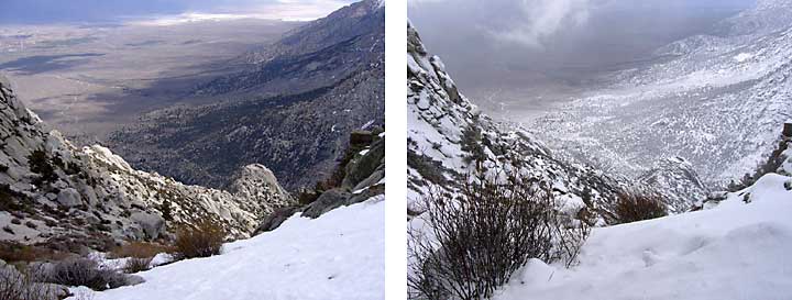
Looking back down Tuttle Creek, Saturday afternoon and Sunday morning in April:
APRIL ATTEMPT: Overnight there were occasional snow showers, the kind you knock off the tent with a single finger thump. At 5am it was cloudy but only a slight skiff of snow had accumulated overnight. We decided to delay getting up until we were positive the clouds would clear. Bad decision. By 6am it was snowing steadily and the snow wasn't flakes - it was graupel (see definition below) and it wasn't sticking to the old icy snow. At first I thought we were just getting some spindrift, but when it started piling up on the tent wall on the upslope side of our platform, I supported the tent wall and asked (or demanded) that Daryn investigate why so much was accumulating.
APRIL ATTEMPT: In the next 10 minutes the graupel went from a curiosity to a real threat. The foot pole was bent and the head pole was at risk of tearing the fabric. Daryn couldn't shovel as fast as it was coming down. I was having trouble supporting the weight of the snow, and the unzipped tent opening was allowing snow to pour into the tent like a mudslide (blocking my exit). This wasn't just snowfall, it was literally running off the rocks and frozen snow, forming a very fluidic river of snow that just happened to be aimed right at my tent. (Robert's tent was below us, and our platform protected his tent.) My gloves were inside the collapsed tent, my boots were in the collapsed vestibule, and I was contemplating frozen extremities if I couldn't get to them. Good thing I had a down jacket on inside the tent. Boots first, gloves can wait: I squeezed out through the remaining tent opening, trying to keep my bare feet inside and somewhat dry. Daryn and I both dug furiously in one small spot and managed to uncover my boots. Salvation!
APRIL ATTEMPT: In all my years of doing snow trips, including growing up in Alaska, I've never seen a flow like this. It reminded me of a wet snow avalanche, but it wasn't an avalanche in the traditional sense. Graupel is lighter than hail (more air) and the temperature was low enough that it stayed dry and didn't stick together. Some avalanche sites mention graupel accumulations, where it rolls down the hill as it did on this trip, as "weak layers" that later cause unexpected releases. Fair warning! Imagine being camped in a streambed when a flash flood comes. In this case a flood of sub-eighth-inch snowballs. We managed to sweep parts of the tent enough to roll it up and drag it out of the flow so we could recover the items inside. Finally I had my gloves! Some flat rocks in the area indicated we had received about 6 inches of graupel in under 2 hours. Snowballs were now rolling down the slope as the sun came out briefly. Time to go! Through a clearing we saw roads at about 5k were white with snow, whereas the day before it was all dry ground to the base of snow tongues at 9.5k (see picture above).
MAY CLIMB: We reached our April campsite at the 9,800 foot level (about 3000 m) and stopped to search for a few items (like my toothbrush) that had been lost in the snow. Found it! All the snow was gone, and willows had popped back up next to the headwaters of the stream that was now flowing. We then proceeded up the chute to waypoint CLIFFB, where the chute narrowed considerably and encoutered a short cliff band that had water flowing over the top of it. We managed to get around the cliff by squeezing through a steep, narrow crack to our right, just above a tree that was growing at the base of the crack.
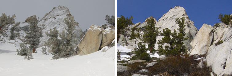
Parting shot - how it looked above us when we left in April, and again in May:
MAY CLIMB: We discovered on our way back down that the best way up the chute (just right of the pinnacle and out of view in the pictures above) was to move up and right out of the main chute onto a small ledge that starts below waypoint CLIFFB, at about 3000m or 9800', and goes up and around to the right of the cliff. Above that was pretty steep snow, abruptly ending in a tree-covered sand-and-boulder side slope. Almost any route through this area works just fine, but be sure you can find the top of the chute (waypoint CLIFFT at about 3200m or 10400') on your way down. Also, avoid going to the ridge too soon. It's easier walking when traversing. Stay in the "plateau" (which isn't level but sort of looks flat on a map) until you're due south of the peak for the fastest walking.
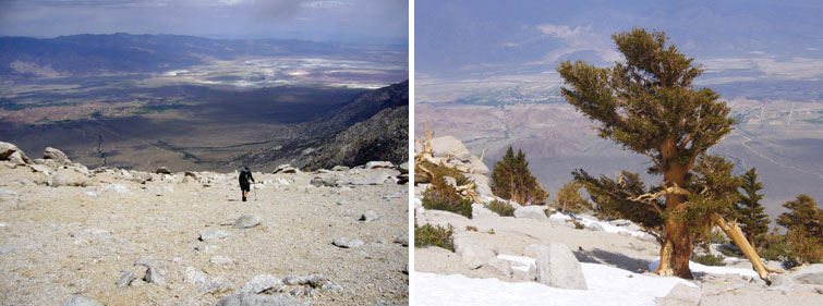
Two views of the summit "plateau" in May:
MAY CLIMB: We enjoyed the summit but it was getting colder and darker by the minute. We had a few rain sprinkles but beat a hasty retreat and the weather pixies seemed to like that. The round trip was under 12 hours, with over 6000' of gain, and it took almost twice as long to climb as to descend. The sandy spots are better to climb when wet (not as loose) but wet or dry you should save energy to enjoy running down this route!
Graupel - snow pellets, lighter and smaller than hail.
Here's a definition from USA TODAY:Snow pellets: White, opaque ice particles that form as ice crystals fall through cloud droplets that are below freezing but still liquid (supercooled). The cloud droplets freeze to the crystals forming a lumpy mass. Scientists call snow pellets "graupel." Such pellets falling from thunderstorms are often called "soft hail." Sleet: Drops of rain or drizzle that freeze into ice as they fall. They are usually smaller than 0.30 inch in diameter. Official weather observations list sleet as "ice pellets." In some parts of the country "sleet" refers to a mixture of ice pellets and freezing rain.
Here's a definition from the USDA's Beltsville Agricultural Research Center:Contact between the snow crystal and the supercooled droplets results in freezing of the liquid droplets onto the surface of the crystals. This process of crystal growth is know as accretion. Crystals that exhibit frozen droplets on their surfaces are referred to as rimed. When this process continues so that the shape of the original snow crystal is no longer identifiable, the resulting crystal is referred to as graupel.
| Here is the graupel we waded down in, mid-calf on my gaiters: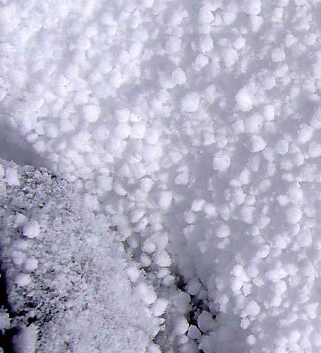
|
Waypoints and Maps - see trailhead page for driving waypoints
![]() Download the Waypoint+ data below as a GPX file for your GPS.
Download the Waypoint+ data below as a GPX file for your GPS.
Datum,North America 1983,GRS 80,0,-1.6E-7,0,0,0
RouteName,1 ,LONE PINE PEAK
RoutePoint,D,OLIVAS, 36.5564166307,-118.1839166880,04/30/2006,06:52:27,OLIVAS RANCH RD TRAILHEAD 6950
RoutePoint,D,P8KSAD, 36.5571500063,-118.1928833723,05/01/2006,00:57:08,PT 8080 SADDLE
RoutePoint,D,PT8080, 36.5560666323,-118.1911833286,04/21/2006,04:36:03,GO NORTH OF PT 8080
RoutePoint,D,P8KSAD, 36.5571500063,-118.1928833723,05/01/2006,00:57:08,PT 8080 SADDLE
RoutePoint,D,CLIFFB, 36.5608999729,-118.2029666901,04/21/2006,04:36:27,CHUTE AT BOTTOM OF CLIFF BAND
RoutePoint,D,CLIFFT, 36.5599230528,-118.2054557800,05/23/2006,18:50:33,PLATEAU AT TOP OF CLIFF BAND
RoutePoint,D,LONEPP, 36.5618333817,-118.2256833315,09/02/2005,14:31:54,4_9 LONE PINE PEAK 12943