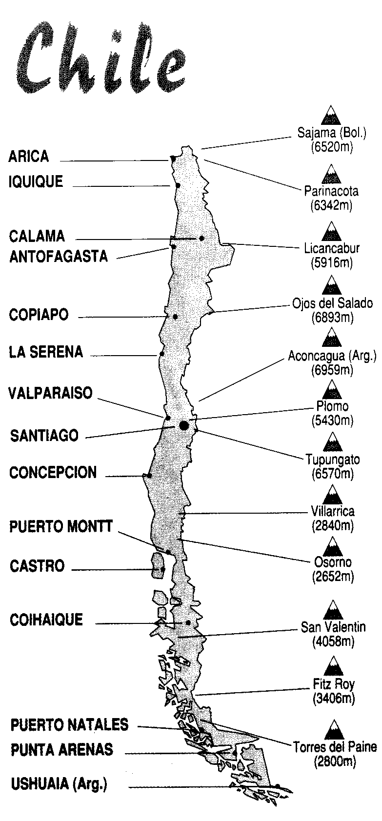
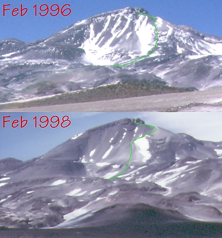
I've included pictures from 1996 (when we didn't make the summit) and 1998 (this report) to illustrate the difference in snow cover. I've marked the route we took on each trip. For context, there is a map of Chile at the bottom of this report.
In 2012 I added an interactive map link (see waypoints below) which allows you to view my waypoints on a Google Map. If you switch the view to Google Earth, the georeferencing seems a bit off but you can see both huts near my waypoints if you zoom in.
The high point of Chile is also the highest active volcano in the world: 22,600'. It's a few hundred feet shorter than Aconcagua (in Argentina), but was once thought to be the high point of the western hemisphere. There is less snow than on Aconcagua, and less than a tenth of the people, making it a completely different type of climb even without the third class summit.
Below are some memories of our recent successful climb, followed by detailed driving instructions complete with GPS coordinates all the way through summit day. If anyone sees this report being distributed by the South American Explorer's Club, please notify me... they have sold unauthorized copies of other things I've written about Chile, and I'm retaining the copyright on this article. You can distribute it for free, but not as part of any paid service.
The whole team
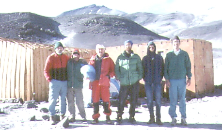
Our group included Organizers Warren Storkman and Steve Eckert, plus David Harris, David Marcus, David Powers, and Bob Wallace (see photo above for proof we all survived - PWSMHE are the first letters of our last names, in the order we appear in the picture). Summit day was 4 Feb 1998. Two of us made the top.
We got some good advice from Bob Villareal, who can offer driver and guide services in the Copiapo area if you don't want to do your own trip. Contact me for his email/phone.
It's always fun flying with a big backpack as carry-on luggage. The questions come almost immediately, and you get to sound like a real adventurer. My flight started in San Francisco and went through Denver, Miami, Santiago on the way to our staging town of Copiapo (pronounced "coh-pee-ah-POH", with emphasis on the last syllable.) On the first leg, I sat next to a travel promoter who looked me over once or twice and went on about what strong legs I must have to climb such heights. I finally spent some time talking about my girlfriend to discourage his attention.
We all had to pick up our bags in Santiago, even though I had checked mine all the way through to Copiapo. You'll get a big hassle (and a $50 charge) if you check a couple of 70 pound bags for a domestic Chilean flight, but if you check them internationally (in both directions) you can get away with it for free. When in Chile, be careful about asking them to check your bags to San Jose - the only San Jose that Lan Chile knows about is in Puerto Rico!
All that talk of confiscation of dried fruit at various border checkpoints seems overdone. I was in Chile and Argentina two years ago, and Chile this year, and no one ever looked in my bags. I listed my reason for visiting as "climbing", and I had over 200 lb of gear including my carry-on luggage. No one looked in any of it, except they dug my nail clipper out of my toilet kit to see if it was a pocket knife (in Santiago).
Money can be exchanged at the airport: They gave us 440 pesos/dollar, and bought the pesos back at a rate of 460 per dollar (less of a return hit than normal). On the other hand, the ATM machine at the Santiago airport gave me an exchange rate of 453 pesos/dollar and was faster than standing in line at the counter. I used about 60,000 pesos during my two weeks not counting airfare or truck rental.
We stayed at Hotel Ingles (337 Atacama, see waypoint INGLES) in Copiapo, which had a great courtyard and no hot water. There's a better hotel over at 150 O'Higgins, where part of our group stayed on the way out, but some of us spent a night in Caldera (an hour away on the coast) at Hosteria Puerta del Sol. After a couple of weeks in the desert, nice accommodations and outside dining with a view of the bay are welcome... but I am getting ahead of myself.
We bought water in Copiapo from a purification wholesaler (Burbujitas is at 364 Henriquez, see waypoint WATER1) - save your 25 liter containers, because they will buy back the container and perhaps any spare water you have. There is no reliable source of fresh water some years, so take lots. We found "becina blanca" or white gas at the Sodimac hardware store at just over a buck per liter (same as US price, see waypoint HRDWRE) and butane canisters were available elsewhere. We also bought some rope and a couple of ten buck lawn chairs there! A large supermarket (see waypoint MARKET) provided fresh fruit, canned goods, bread, pasta, etc. I don't have the street addresses of the hardware and grocery stores, but there are GPS waypoints for them below. Unleaded gas was about 55 cents/liter.
Maps in Chile are worse than useless. They don't all show the same roads, they leave out landmarks, and they are not to scale. The tourism people, for instance, said it was 31km to the coast when it was really over 70km. You can ask for a map, and you'll get one, but you'll do better with a GPS and the waypoints below than with any map we saw. Plotting the GPS waypoints with the interactive map link below shows you how badly distorted the maps are (see Chile map below for general locations).
We rented 4-door Toyota 4WD pickups with a short little bed. I've never seen this model outside South America, but Hertz rents them for just over $100/day (in week increments). Daily rates are higher ($150?). You can get 3 people and gear in comfortably - 4 would be tight, but the distances to drive are not all that long. Hertz will meet flights at the tiny Copiapo airport, or see waypoint HERTZ for their office in town. Marcus got stopped for driving without a seatbelt, but other than that it's pretty much like driving in the US.
Be sure to check-in with the Carabineros in Copiapo (just east of plaza, see waypoint CARAB) and leave your passports at their outpost on Laguna Verde (waypoint VERDEC). Ojos is apparently the only peak in Chile which requires permits. We got ours in advance, from the Chilean government, but some say you can get them from the embassy in Washington DC or even from the Carabineros in Copiapo.
We drove a couple of hours toward Laguna Santa Rosa the same day we bought supplies (26 Jan 98), and camped just over 9k in a gravel area off the road (see waypoint CAMP1)
Camp 1 Backdrop
On the way, we sat under the only shade tree for miles and had lunch near a spring (see waypoint 89KM). A short afternoon hike gave us a close-up view of the desert canyons complete with vicuna / guanaco / llama bones and droppings (never figured out which beast it was). That night was warm and clear, with great southern hemisphere star-gazing. The wind and dust increased nightly after that, and we soon took to tents. The next morning we drove a bit further to a place around 10k that featured a pipe gushing water near a spring (see waypoint WATER2). Not sure how safe the water was, but it would be an alternative to filling up in town.
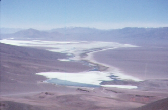
A morning hike was followed by driving to the pass west of Laguna Santa Rosa (13.5k, see waypoint PASS). Some of the more eager climbers dreamed of climbing a 16k peak near the pass, but turned around about 15k after burning up their time budget and acquiring slight headaches. We spent the night by the salt lake, in the shelter of a huge rock (see waypoint CAMP2).
Laguna Santa Rosa
There is a hut in the area, but others were using it and we rather liked watching the flamingos from our lakeshore campsite. Already showing signs of strain, we had some long conversations about where (and how high) to camp the next day. It was depressing to hear that people were not willing to ascend slowly enough to avoid altitude symptoms, which had been one of my goals for the trip. (My theory is that you do not acclimatize faster when you are uncomfortable, and may even acclimatize more slowly, but in spite of my experiences on Aconcagua and Denali this theory met some pretty stiff criticism. Everest climbers spend 9 days getting from 9k to 18k and then take a long layover before going higher, according to a recent NOVA special.)
On day 3 we dayhiked from 13k to 15k before driving across the salt flats to our next campsite at just over 14k. David Marcus hiked and hitched back over the pass to look for some dental hardware that was missing, scoring some fruit and cookies from the miners who took pity on him. I would have preferred to spend another night below 13k, but most of the group was rabid to camp as high as possible. I spent the evening with a bad headache, but our campsite beside a waterfall was a great one (see waypoint CAMP3).
Rio Lamas Waterfall
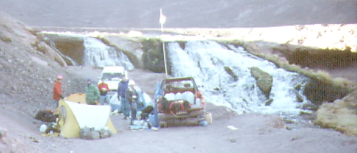
The water is apparently from the Rio Lamas drainage, which originates on Tres Cruces, and the road down to it was built to allow a mine to truck water about 30km away.
We spent day 4 recovering from moving up too much the day before. Several of us had headaches, and one (not me) did not eat any dinner on day 3. Everyone got in at least 1000' of gain on various day hikes, and we spent a second night at the waterfall. The plan was to take an easy day, then move to Laguna Verde and try a taller afternoon hike on day 5.
We had a pulse oximeter with us, which measures how well oxygenated your blood is. 100% is normal at sea level, and the move from the salt lake at 12k to the waterfall at 14k had dropped some of us from 96 to 84. Mid-60s represent critical levels, but my heart rate was a reliable indicator of what the oximeter was going to say. Banging away at 100+ beats/min while resting meant I was not acclimatized. Experience suggests that well acclimatized climbers can hold 1000 ft/hr without maxing their heart rates. This trip showed us that hyperventilating or holding your breath can alter the pulse oximeter readings dramatically, but it's hard to control the rate at which your heart beats. I think I'll keep using the old way.
Laguna Verde West

David Marcus had a map which showed Laguna Verde at 14.7k, but it's really more like 14.2k (see waypoint VERDEW, the picture above, for the first place you can hike to the lake shore). Realizing the low elevation, the group decided to spend no time there and head immediately for camp just above 15k along the 4WD road leading to Ojos (see waypoint CAMP4).
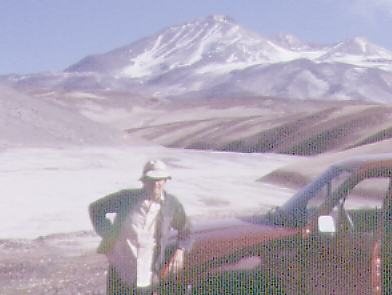
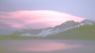
View from 15k - 1996
Later we found out that the Carabineros (police?) station has been moved from near the Hosteria L Murray ruins to Laguna Verde, and that we should have left our passports with the Carabineros while we climbed. Oops. The International Highway has been re-routed since two years ago, and now bypasses the old (abandoned, see waypoint CARABA) Carabineros station. The new station on the lakeshore (see waypoint VERDEC) is a huge improvement, but 20km out of the way. The fabled hot springs at Laguna Verde (waypoint VERDEH) are inside a tiny shack that looks filthy from the outside. Skip them. None of us went in, and we saw no flamingoes there. Someone has assembled several horse-type collections of bones on the shore, and it was fairly crowded with people.
Day 6 saw a couple of us dayhiking to 17k from our camp at 15k, then we moved camp to 16k (see waypoint CAMP5) and several people hiked up to the lower hut (almost 17k) from our campsite. Along the way we winched out some Belgian climbers who tried to drive up the sandy wash without a 4WD truck. (I brought some steel tow cables and a small come-along, things which the Hertz people will not provide for you.) They left their truck and we shuttled them up to the hut in exchange for some fuel. That shuttle turned out to be important, because one of the Belgians was a doctor who helped save a life. Without the ride, he would not have been in the right place at the right time.
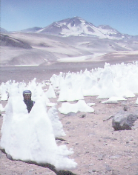
I should clarify that these day hikes were anything but exciting. The peaks were all 18k and higher, out of range for the kind of conditioning we were after. We just walked over sand and talus until the altimeter said to turn around. Ugh. This year, definitely due to El Nino, there were penitentes (spikes of melted ice up to 2 meters high) as low as 15k. These could have provided good drinking water, but we just used them as backdrops for pictures.
Penitentes at 15k
Andino Hut 17k
We moved up to the Andino Refuge (about 17k, see waypoint HUT17K) on day 7, then dayhiked up to about 18k. This hut is also referred to as Ruda Camp and the Atacama Refuge - it was where everyone started to feel like we were really at high altitude. No one could hike fast and escape a headache. At sea level, many of us were capable of 3000 ft/hr climb rates. My plan had been to make sure we could climb at least 1000 ft/hr without feeling bad before moving camp up, but that plan was now totally shot. Several people were worried about "intestinal looseness", there were increasingly heavy clouds each day, and the group was in danger of splitting up. Some felt vague AMS symptoms, others felt that they were going to weaken if we waited any longer.
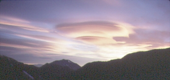
Back at the 14k waterfall, we had been warned about a weather front moving in from Peru. The clouds were now lasting most of the day, in deep lenticular stacks, but we never saw any precipitation. There were some nice sunsets, however.
Sunset at 17k
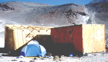
Tejos Hut 19k, by Marcus
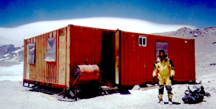
Since there was nothing we could do about the weather, we carried water and fuel up to the Tejos Refuge (at about 19k, see waypoint HUT19K) on day 8. This 2000' climb takes about 3 hours up and one hour down, and some people wanted to turn around right away because they felt worse after resting than when they first arrived (another sign of incomplete acclimatization - you should feel fine resting at whatever altitude you climb to). This L- shaped hut is constructed from very solid steel shipping containers welded together. It once had solar cells, fluorescent lights, a shower fired by a fuel oil heater, etc., but the fancy stuff has all broken since it was built in the 1980s. The windows are intact, and there is often silty water within walking distance.
I will always remember the carry day: I was trying to lobby people to slow down the pace of the trip, and I was being told (specifically) that I did not belong on high altitude trips. My thinking was that summitting on day 6 had caused a death one year ago, and 30% of a Chilean group trying to summit on day 8 was too sick to go above the 17k hut while we were there... so why take the risk? Why not slow the ascent? The downside of moving camp up slowly seemed to boredom, the downside of moving too quickly was serious illness or death. Those wanting to move faster would not tolerate a conversation phrased in these terms, and I was left muttering to myself. Just 7 months earlier I had done a 6000' dayhike to the summit of Denali (20k) after a long period of acclimatization, with no headache or other altitude symptoms. I was certainly not as well acclimatized on this trip.
On this trip we had to confront our own feelings about risk taking, especially when we helped keep someone from another group alive. The KJV Bible says "For what shall it profit a man, if he shall gain the whole world, and lose his own soul? Or what shall a man give in exchange for his soul?" (Mark 8:36-37) Please forgive an excess of editorializing, but my first priority is always coming home and I don't see why these trips have to be painful. No mountain is worth dying for. What does it profit you to make the summit and die on the way down?
It seems my concerns about ascending too fast were well founded. The night after our carry, the Chilean team returned to the high hut after a long day, and one person's lungs started filling up with pulmonary edema. The Belgian group had a doctor along, who gave the sick climber a shot and walked him down to the low hut (possibly ending the doctor's summit bid). We had rented a Gamow Bag (portable hyperbaric chamber) in which the Chilean spent half the night. The next morning we used one of our trucks to evacuate him to a mining hospital, since they had been dropped off and had no way to leave the mountain.
The Chilean schedule was just 2 days faster than ours. Other groups summitting on Day 6 or Day 8 seem to come back after dark, indicating they are climbing slowly due to lack of acclimatization. Some get lost trying to find the 19k hut after dark. Last year a frozen body was tied to a truck for the ride out. This year one person who misjudged himself cost many people many hours of effort. Too bad he was not more conservative, but he was indeed fortunate to have so many helpers around. We were alone on the mountain at the high hut, and would not have received such assistance.
We moved up to the 19k hut on day 9, planning to summit the next day instead of laying over as I had planned. Summit fever takes over, and tempers get short. I spent the afternoon eating and drinking, but my heart rate never fell below 110 and my blood oxygen was below 75%. Not encouraging. The same person who told me I did not belong at high altitude was now requesting an extra day in the schedule. We had supplies for 14 days, but we had to either split the group or climb on the compromise schedule of a summit attempt on Day 10. I mourned the loss of a comfortable schedule, but stuck with the plan. "Ready or not here we come."
Day 10, 4 Feb 1998, peak day: We were up at 0330 and climbing at 0430, with no moon and no scouting hike to figure out how to find the route. (That was something I wanted to do during the layover day we decided not to take.) Use the GPS waypoints HUT19K and PEAK1 through PEAK6 below to avoid the wasted time and effort we went through. Snow cover varies immensely from year to year, with the current El Nino snow providing lots more snow at low elevations but much less snow up high than 2 years earlier.
96/98 Routes
It was no surprise that we hit a penitentes field and got off route, but counting headlamps and finding one missing caught me off guard. We were losing people within the first 30 minutes of climbing?
We had previously decided as a group that anyone not getting from 19k to 21k in 4 hours should turn back, a pace of 500 ft/hr including stops and mistakes. One person had turned back, saying our 700 ft/hr initial pace was too fast. An hour or so later he caught up with us again, having returned to the hut and decided to give it a go anyway. The push of catching us brought on a fit of "technicolor yodeling", but he continued up for a while before turning around again. Meanwhile, another person was having trouble with the short and frequent stops required to keep everyone together prior to sunrise. He turned around with a headache and some frustration at the slow "death march" pace we were keeping. The loose pumice footing did not help any of us.
Summit day sunrise
This year there was a lot of ice on the peak, but none on the route. Two years ago we needed ice axe and crampons, this year we just used ski poles. Our oldest climber dropped back just before we crossed above the ice fields, and Warren Storkman slowed down shortly after that but continued to the crater rim at 22k. Looking over at the boulder field and short third class climb to the summit ridge, Storkman decided to call it a day. Now it was David Powers, the Belgian doctor, and me... slowly creeping around the inside edge of the crater toward the fixed rope. The crater is not as big as it looks from a distance, but you could probably build a football field in it. This trip was much warmer than the last one, with the lowest temp of the day around 10F (fully 20 degrees warmer than two years ago, and with less wind).
There is a good trail spiraling up and right inside the crater, and it leads to some large boulders just below the right-most notch in the ridge. Don't cross the center of the crater, which is supposed to have hollow breakthroughs. We could see a metal flag swinging back and forth on the summit, and eventually the fixed rope came into view. This 11mm climbing rope had been added to the route only a couple of weeks earlier, and the well-worn goldline it replaced was still there. The peak with a flag and register is on the far right of the rim (looking at the rim from inside the crater), but it's really hard to tell if it's the highest point along the ridge.
Summit Route
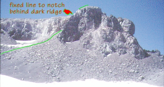
The "fixed" rope (free at one end) could be flipped onto a sheer face, or over onto easy 3rd class rock. There is about 50' of climbing, then another 50' of scrambling to the summit. I've heard reports that this is class 5.2 climbing, but either they were off route or too tired to rate it properly. We all agreed it would have been safe to climb with no rope (even in plastic boots) at lower elevation, but everyone ran an ascender or a prussik up the rope just in case. No one wanted a belay, but I rapped off to save time after watching the others downclimb while holding a prussik knot open with one hand. (I'm not sure the reflex to grab the rope would allow opening your hand in the event of a fall - cavers have tested "let go to lock up" safety devices and concluded that the urge to tighten your grip during a fall is too strong.)
Summit Team
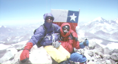
In our joy to be at the top, 22,600', we remembered to check the time (8.5 hrs up) but forgot to sign the register. Perhaps there was an oxygen deficit leading to a drop in IQ, but I prefer to call it "excitement" rather than "stoopidity". The doctor yodeled on the way down, and we slowed to watch for other signs of trouble after realizing he had not been eating or drinking enough. It took about 2 hours to descend to the high hut at our revised pace, following which most of us packed up and went to the lower hut for the night.
A common myth is that high altitude climbs in latitudes such as Nepal and northern Chile are less demanding than the same altitude further from the equator. I have now been over 20k in Nepal, Argentina, Chile, and Alaska, and 18k in Russia and Mexico. Each time, I set my altimeter at home (California) at sea level and find that it is accurate at airports along the way. I have observed "linear errors" in the Sierra Nevada, and Avocet confirms that +/- 10% errors can be expected due to temperature differences between winter and summer. These errors are due to the differences in the weight (and therefore the density) of the air above you. Re-calibrating your altimeter daily may NOT be a good idea, because it keeps you from accurately determining the percentage error in altitude gain from the start of your trip. Figuring out the percentage linear error and calculating projected elevation readings is often the better technique, especially when there are only a few "known" elevations on the trip.
I have never seen errors on foreign trips larger than errors on trips here in California. Rumors of Denali (at 20k) having air as thin as 24k in Nepal are false, at least in terms of the air pressure. The same is true of Chile and Nepal, where calibrating at sea level and calculating the error at a known point half way up allowed me to accurately predict what the altimeter would read at the summit. Even without adjusting for linear error, and without re-calibration after leaving my 450' home in California, my altimeter was off only 400' on Denali (20.2k), 600' on Aconcagua (22.8k), and 900' on Ojos (22.6k). Storms did produce 900' variations on Denali, but talk of 4000' variations with latitude seem to be nonsense. I have never been on a big peak where the altimeter read higher than expected!
Day 11 started with pancakes at 17k for me (Krusteaz pancake mix is amazingly tolerant of high-altitude cooking if your stove has an adjustable flame), then frantic packing and a drive back to Laguna Verde. We were looking for the rest of the Belgian group (who had summitted without their doctor, then went down without him, since he was welcome to climb with us). We finally found them at the OLD Carabineros station, and tore off down the international highway back to Copiapo. Staying north of Laguna Santa Rosa is a faster way back (see the Route 4 waypoints), but not as good for acclimatization hikes on the way up. It's about 300km either way, so take at least 40 liters of fuel in addition to the 65 liters in the gas tank.
We only got 2 people out of 6 to the summit, but we got everyone home without injury. Several people set personal altitude records on peak day. On the other hand, no one really wanted to hang around for an attempt at Tres Cruces or Pissis. The Belgians found a duffel bag that bounced off our truck on the way back, the Chileans got written up as heroes in the local paper (apparently with little mention of the rescue by two other nations), and we found that Becker beer tastes better than Cristal. We all headed home the next day, arriving in San Francisco with a major storm in progress. One week later I heard that Peru has bad flooding, and that it rained in the desert town of Copiapo, so perhaps our timing was good after all! No on ever "conquers" a mountain, and El Nino is real: you must sneak up between tantrums.
> Can you tell me more about the rock section below the
> summit?  Before reading your 1998 trip report, I was planning on
> bringing rope and rock pro based on my guide book that rates the rock at
> 5.4!  Your account of 3rd class rock with a fixed line has me
> re-thinking how much rock climbing gear to bring (if any).
> If you were returning to Ojos, would you expect to find a fixed line?
> Can you tell me more about the rock quality?  Will it take pro?  What kind?
The rock is, well, basically shit. It's an old volcano. I remember thinking that in the Sierras or Rockies, the climbing at the summit would be considered a minor scramble. The only need for a rope comes from being weak and having bad judgement/coordination at almost 7000 meters (22600' = 6890m).
The fixed line was only used for about 50'. My memory isn't all that clear but I don't think slings would be very useful in the middle, but nothing OTHER than slings would work at the top. Wide cams might be better midway. Chocks and nuts I wouldn't take at all.
It was only last year, but I was kind of fuzzy at the top.
I went up the fixed rope and didn't search for pro locations at all. If the rope had been missing, I would have felt OK climbing without it (and I don't do much technical climbing). It was nice to rap down on... but my partners didn't think it was worth the risk and just slid an ascender down it while downclimbing. I trusted it. Bad judgement?
By the time you get there, let's hope the rope has been replaced. If not, it will be deteriorated and shouldn't be trusted. I think it was tied off to a large boulder on the ridge, so perhaps one long sling to anchor your rap line would be good.
>I climbed Ojos del Salado in 97 and I am planning to climb Tres Cruces next
>year. I saw your Ojos report and found it very helpful. Could you tell me if
>the Lamas River, the river just under Tres Cruces, has water good to drink??
We took bottled water. Hiking above the waterfall reveals dead animals in the drainage... probably not from the water itself, but the water was far from clear and we didn't risk it despite the mine truck. Great place to camp, however!
> do I have to do something with the car, change something at the engine
> when we want to drive to Refugio Atacama because of the 5000m?
No, the vehicles there are set up for the area already. It would be best to let the rental company know how high you are going, and ask them if the truck has an altitude compensator on it, but there's really nothing you can change yourself. You will notice a lack of power up high, but by then you're going so slow due to rocks in the road that you can just use a very low gear.
Distances are from start of trip, not per leg. NO SERVICES ANYWHERE! Distances in parentheses are what we saw on a road sign, not verified! GPS waypoints are shown in square [brackets].
0km: start from near Copiapo town center
5km: filled with gas at Shell station on main drag (250 pesos/liter)
13km: turned left (NE) at large sign over road (all paved), waypoint [13KM] - go toward Paipote (Almagro is further in same direction)
29km: turned right (E) onto dirt road marked LaCoipa (110km), waypoint [29KM] - also marked Mina Marte (169km) and Paso de San Francisco (256km)
64km: passed by mine ruins (Pucios), did NOT turn left, waypoint [64KM] - left turn keeps you on international highway, this was our return route - right turn takes you over the 13.5k pass near Laguna Santa Rosa, shorter
82km: turned right (E) following sign for Mina Marte (97km), waypoint [82KM]
89km: passed by spring on left near rough farm house, waypoint [89KM] - just past spring is a fine place to have lunch under a shade tree
101km: took left branch of "Y" (NE), again toward Mina Mart (78km), waypoint [101KM]
125km: camp along road at about 9k elevation, waypoint [CAMP1] - there is also camping near a spring with pipe at about 10k, waypoint [WATER2]
150km: went over pass at 13,500', 2.5 hr from Copiapo, waypoint [PASS] - from pass you can see Laguna Santa Rosa and snowy mountains (Tres Cruces) - our route goes left of Tres Cruces, which obscure Ojos del Salado
156km: go straight past left turn marked Laguna Santa Rosa, waypoint [CAMP2] - left turn takes you to camping area (hut and huge rock are both options) - our route goes around right side of lake to pick up power lines
176km: turned left (NW), away from Mina Marte, waypoint [176KM] - follow sign to Paso de San Francisco (111km) - do NOT follow sign to Mina Marte (5km)
179km: did NOT turn right toward Rio Lamas, continue (NW) toward Control Fronterizo - this is the turn to take if you are heading for Tres Cruces
191km: turned right (N) to parallel power lines (vague intersection), waypoint [191KM]
201km: turned right (E) away from sign for Control Fronterizo, waypoint [201KM] - this is where you re-join the International Highway - 11km from junction to agricultural checkpoint? (no idea what the station is checking)
2xxkm: Rio Lamas drainage forms green valley south of highway, waypoint [WATER3] - look carefully for road down to parking and waterfall campsite, waypoint [CAMP3]
225km: short XC drive to eastern end of Rio Lamas road, waypoint [LAMASE]
272km: ABANDONED carabineros station and ruins of Hosteria L Murray at 14,600' - the International Highway has been re-routed to avoid this area - to reach this point, turn south just after dropping through a band of light cliffs - 4WD road goes south from old highway about 50m west of old gate and stop sign [CARABA] - approaching from the west: Turn off Intl Hwy at waypoint [269KM] - approaching from Laguna Verde: Turn off Intl Hwy at waypoint [274KM]
274km: junction between old (south) and new (north) international highways, waypoint [274KM]
284km: Laguna Verde - drive along lake [VERDEW] for a ways, follow good road to shore - turn left and go down to hot springs [VERDEH] and new carabineros station [VERDEC] - need to show climbing permit here, and leave passport
299km: back to old carabineros station, waypoint [CARABA]
305km: campsite in wash at about 15k (6 hr from Copiapo), waypoint [CAMP4]
314km: campsite in broad valley at about 16k, waypoint [CAMP5]
320km: first hut (Refugio Andino, aka. Ruda or Atacama, 17k) small wood shelter, waypoint [HUT17K] - old 4WD road had some soft sand approx 3km before hut, apparently washed out now - new 4WD road approaches hut from the north, goes through boulder fields - some running water in the afternoon, definitely fouled by human waste!
Possible to drive to second hut, waypoint [HUT19K], but deep sand drifts near the first hut make this impractical. Once up the first several hundred feet, however, the driving would be pretty easy. Need very wide tires, and need to let the air out (bring a pump?), and there is a big risk of rolling over sideways (unlike the lower portion of road).
Returning to Copiapo, stay on the International Highway by going straight at the intersection with waypoint [201KM]. This will take you to the Control Fronterizo [INSPCT], where the most important thing you must convey is that you have NOT been to Argentina. Say things like "alpinistas" and "ojos del salado" if you don't speak Spanish, and have your climbing permit handy. Just after this checkpoint, turn left at the Y intersection [RETJCT] and head (SW) across the flats. You'll enter a narrow canyon and climb to a 14.5k pass {RETPAS] with many switchbacks before dropping back into the drainage you started in. Your route will rejoin the roads above at the intersection with waypoint [64KM], where the distinctive mud brick ruins should look familiar.
There are four routes in the waypoints below:
I left my GPS set for NAD83 datum, since I was not using a good local map. You will get really bad results if you use some other datum, or if you try to match these coordinates up with a good map.
NOTE: The interactive map link below is auto-generated, and by default it uses a map overlay only availble in the USA. Pull down the menu in the upper right corner of the map and choose 'terrain' for Google Map elevation lines.
![]() Download the Waypoint+ data below as a GPX file for your GPS.
Download the Waypoint+ data below as a GPX file for your GPS.
Datum,North America 1983,GRS 80,0,-1.6E-7,0,0,0
RN,1 ,IN COPIAPO
RP,D,CARAB , -27.360543693, -70.3237385396,02/12/1998,00:13:04,CARABINEROS-CPO
RP,D,WATER1, -27.372645820, -70.3264422063,02/12/1998,00:00:27,BURBUJITAS-CPO
RP,D,HERTZ , -27.362651910, -70.3469181899,02/11/1998,23:53:05,TRUCK RENTAL
RP,D,HRDWRE, -27.372951592, -70.3360981587,02/11/1998,23:53:38,SODIMAC HARDWARE
RP,D,MARKET, -27.378385664, -70.3142810706,02/11/1998,23:53:54,GROCERIES
RP,D,INGLES, -27.365479042, -70.3381204605,02/11/1998,23:54:21,HOTEL 337 ATACAMA
RN,2 ,COPIAPO TO HUT19K
RP,D,13KM , -27.419123138, -70.2745307330,02/11/1998,23:55:00,PAIPOTE TURNOFF
RP,D,29KM , -27.317290391, -70.1630527619,02/11/1998,23:55:28,LACOIPA DIRT ROAD
RP,D,64KM , -27.159571136, -69.8885233048,02/11/1998,23:56:22,RUINS-INTL HWY JCT
RP,D,82KM , -27.108802284, -69.7243666649,02/11/1998,23:57:06,MINA MARTE TURN
RP,D,89KM , -27.121687616, -69.6712911967,02/11/1998,23:57:47,SPRING AT 1800M
RP,D,101KM , -27.147211517, -69.5900900010,02/11/1998,23:58:15,MINA MARTE TURN
RP,D,CAMP1 , -27.073429311, -69.3901635054,02/11/1998,23:59:38,CAMP AT 9K
RP,D,WATER2, -27.054680670, -69.2955941800,02/12/1998,00:03:30,SPRING-PIPE AT 10K
RP,D,PASS , -27.077195133, -69.2274016980,02/12/1998,00:04:31,13.5K W OF LSROSA
RP,D,CAMP2 , -27.088787640, -69.1790200118,02/12/1998,00:05:09,LAG SANTA ROSA JCT
RP,D,176KM , -27.127631391, -69.0107329376,02/12/1998,00:06:44,AWAY FROM MINA MARTE
RP,D,191KM , -27.009104575, -69.0649563912,02/12/1998,00:07:07,FOLLOW POWER LINES
RP,D,201KM , -26.930805529, -69.0200293902,02/12/1998,00:08:04,E INTL HWY JCT
RP,D,WATER3, -27.081572498, -68.9304167870,02/12/1998,00:08:49,TURN TO WATERFALL
RP,D,CAMP3 , -27.081915821, -68.9334047679,02/12/1998,00:08:59,RIO LAMAS WATERFALL
RP,D,LAMASE, -26.996653761, -68.8771695737,02/12/1998,00:27:48,E RIO LAMAS ROAD
RP,D,CARABA, -26.932844008, -68.5967285279,02/12/1998,00:22:56,ABANDONED CARABINERO
RP,D,VERDEW, -26.890111138, -68.4925192595,02/12/1998,00:12:40,W END LAG VERDE
RP,D,VERDEH, -26.891302039, -68.4861356858,02/12/1998,00:14:37,LAG VERDE HOT SPR
RP,D,VERDEC, -26.893324341, -68.4701658133,02/12/1998,00:14:44,CARABINEROS-VERDE
RP,D,269KM , -26.911960329, -68.6101556662,02/12/1998,00:24:01,BLUFF OJOS SHORTCUT
RP,D,274KM , -26.917464222, -68.5622889642,02/12/1998,00:13:55,OLD-NEW INTL HWY JCT
RP,D,CAMP4 , -26.969697560, -68.5874588136,02/12/1998,00:15:17,CAMP AT 15K
RP,D,CAMP5 , -27.013390661, -68.5505408887,02/12/1998,00:15:45,CAMP AT 16K
RP,D,HUT17K, -27.059792961, -68.5469465610,02/12/1998,00:16:19,ANDINO REFUGE
RP,D,HUT19K, -27.087349976, -68.5371459369,02/12/1998,00:16:44,TEJOS REFUGE
RN,3 ,HUT19K TO CRATER
RP,D,HUT19K, -27.087349976, -68.5371459369,02/12/1998,00:16:44,TEJOS REFUGE
RP,D,PEAK1 , -27.092451538, -68.5397476796,02/12/1998,00:18:14,ROAD END-SHOULDER
RP,D,PEAK2 , -27.093932117, -68.5409224872,02/12/1998,00:18:39,ACROSS DRAINAGE
RP,D,PEAK3 , -27.096367563, -68.5417807940,02/12/1998,00:18:56,BOTTOM SWITCHBACKS
RP,D,PEAK4 , -27.104752065, -68.5429448728,02/12/1998,00:19:16,TOP SWITCHBACKS
RP,D,PEAK5 , -27.104478563, -68.5432613734,02/12/1998,00:19:42,TOP OF ICE FIELD
RP,D,PEAK6 , -27.106833459, -68.5445059184,02/12/1998,00:20:01,CRATER ENTRANCE
RN,4 ,INTL HWY RETURN
RP,D,HUT17K, -27.059792961, -68.5469465610,02/12/1998,00:16:19,ANDINO REFUGE
RP,D,CARABA, -26.932844008, -68.5967285279,02/12/1998,00:22:56,ABANDONED CARABINERO
RP,D,269KM , -26.911960329, -68.6101556662,02/12/1998,00:24:01,BLUFF OJOS SHORTCUT
RP,D,201KM , -26.930805529, -69.0200293902,02/12/1998,00:08:04,E INTL HWY JCT
RP,D,INSPCT, -26.841053535, -69.0451724175,02/12/1998,00:29:27,CONTROL FRONTERIZO
RP,D,RETJCT, -26.835694398, -69.0527361631,02/12/1998,00:31:43,LEFT TURN TO COPIAPO
RP,D,RETPAS, -26.823157837, -69.2123168707,02/12/1998,00:31:48,14K PASS TO COPIAPO
RP,D,64KM , -27.159571136, -69.8885233048,02/11/1998,23:56:22,RUINS-INTL HWY JCT
RP,D,29KM , -27.317290391, -70.1630527619,02/11/1998,23:55:28,LACOIPA DIRT ROAD
RP,D,13KM , -27.419123138, -70.2745307330,02/11/1998,23:55:00,PAIPOTE TURNOFF
WP,D,CARAB , -27.360543693, -70.3237385396,02/12/1998,00:13:04,CARABINEROS-CPO
WP,D,WATER1, -27.372645820, -70.3264422063,02/12/1998,00:00:27,BURBUJITAS-CPO
WP,D,HERTZ , -27.362651910, -70.3469181899,02/11/1998,23:53:05,TRUCK RENTAL
WP,D,HRDWRE, -27.372951592, -70.3360981587,02/11/1998,23:53:38,SODIMAC HARDWARE
WP,D,MARKET, -27.378385664, -70.3142810706,02/11/1998,23:53:54,GROCERIES
WP,D,INGLES, -27.365479042, -70.3381204605,02/11/1998,23:54:21,HOTEL 337 ATACAMA
WP,D,13KM , -27.419123138, -70.2745307330,02/11/1998,23:55:00,PAIPOTE TURNOFF
WP,D,29KM , -27.317290391, -70.1630527619,02/11/1998,23:55:28,LACOIPA DIRT ROAD
WP,D,64KM , -27.159571136, -69.8885233048,02/11/1998,23:56:22,RUINS-INTL HWY JCT
WP,D,82KM , -27.108802284, -69.7243666649,02/11/1998,23:57:06,MINA MARTE TURN
WP,D,89KM , -27.121687616, -69.6712911967,02/11/1998,23:57:47,SPRING AT 1800M
WP,D,101KM , -27.147211517, -69.5900900010,02/11/1998,23:58:15,MINA MARTE TURN
WP,D,CAMP1 , -27.073429311, -69.3901635054,02/11/1998,23:59:38,CAMP AT 9K
WP,D,WATER2, -27.054680670, -69.2955941800,02/12/1998,00:03:30,SPRING-PIPE AT 10K
WP,D,PASS , -27.077195133, -69.2274016980,02/12/1998,00:04:31,13.5K W OF LSROSA
WP,D,CAMP2 , -27.088787640, -69.1790200118,02/12/1998,00:05:09,LAG SANTA ROSA JCT
WP,D,176KM , -27.127631391, -69.0107329376,02/12/1998,00:06:44,AWAY FROM MINA MARTE
WP,D,191KM , -27.009104575, -69.0649563912,02/12/1998,00:07:07,FOLLOW POWER LINES
WP,D,201KM , -26.930805529, -69.0200293902,02/12/1998,00:08:04,E INTL HWY JCT
WP,D,WATER3, -27.081572498, -68.9304167870,02/12/1998,00:08:49,TURN TO WATERFALL
WP,D,CAMP3 , -27.081915821, -68.9334047679,02/12/1998,00:08:59,RIO LAMAS WATERFALL
WP,D,LAMASE, -26.996653761, -68.8771695737,02/12/1998,00:27:48,E RIO LAMAS ROAD
WP,D,CARABA, -26.932844008, -68.5967285279,02/12/1998,00:22:56,ABANDONED CARABINERO
WP,D,VERDEW, -26.890111138, -68.4925192595,02/12/1998,00:12:40,W END LAG VERDE
WP,D,VERDEH, -26.891302039, -68.4861356858,02/12/1998,00:14:37,LAG VERDE HOT SPR
WP,D,VERDEC, -26.893324341, -68.4701658133,02/12/1998,00:14:44,CARABINEROS-VERDE
WP,D,269KM , -26.911960329, -68.6101556662,02/12/1998,00:24:01,BLUFF OJOS SHORTCUT
WP,D,274KM , -26.917464222, -68.5622889642,02/12/1998,00:13:55,OLD-NEW INTL HWY JCT
WP,D,CAMP4 , -26.969697560, -68.5874588136,02/12/1998,00:15:17,CAMP AT 15K
WP,D,CAMP5 , -27.013390661, -68.5505408887,02/12/1998,00:15:45,CAMP AT 16K
WP,D,HUT17K, -27.059792961, -68.5469465610,02/12/1998,00:16:19,ANDINO REFUGE
WP,D,HUT19K, -27.087349976, -68.5371459369,02/12/1998,00:16:44,TEJOS REFUGE
WP,D,PEAK1 , -27.092451538, -68.5397476796,02/12/1998,00:18:14,ROAD END-SHOULDER
WP,D,PEAK2 , -27.093932117, -68.5409224872,02/12/1998,00:18:39,ACROSS DRAINAGE
WP,D,PEAK3 , -27.096367563, -68.5417807940,02/12/1998,00:18:56,BOTTOM SWITCHBACKS
WP,D,PEAK4 , -27.104752065, -68.5429448728,02/12/1998,00:19:16,TOP SWITCHBACKS
WP,D,PEAK5 , -27.104478563, -68.5432613734,02/12/1998,00:19:42,TOP OF ICE FIELD
WP,D,PEAK6 , -27.106833459, -68.5445059184,02/12/1998,00:20:01,CRATER ENTRANCE
WP,D,INSPCT, -26.841053535, -69.0451724175,02/12/1998,00:29:27,CONTROL FRONTERIZO
WP,D,RETJCT, -26.835694398, -69.0527361631,02/12/1998,00:31:43,LEFT TURN TO COPIAPO
WP,D,RETPAS, -26.823157837, -69.2123168707,02/12/1998,00:31:48,14K PASS TO COPIAPO