Shepherd Pass, Symmes Creek
Revised 11 Jun 2012 - please send updates to the webmaster
WARNING: Bears have been seen at low-elevation trailheads in this area (Shepherd Pass in particular) so don't assume your car is safe with food in it.
Shepherd Pass provides direct access to Williamson and Tyndall, in addition to the abandoned Junction Pass trail, as it crosses into the Kern drainage. The trailhead (waypoint SHPRDT) was accessible to regular passenger cars as of June 2001, with careful driving, but some may choose to leave their car at the stock trailhead (waypoint SHPRDH) and walk a bit further to avoid the roughest road. The driving directions in Secor's book are fairly accurate, but the mileage seems a bit high in places.
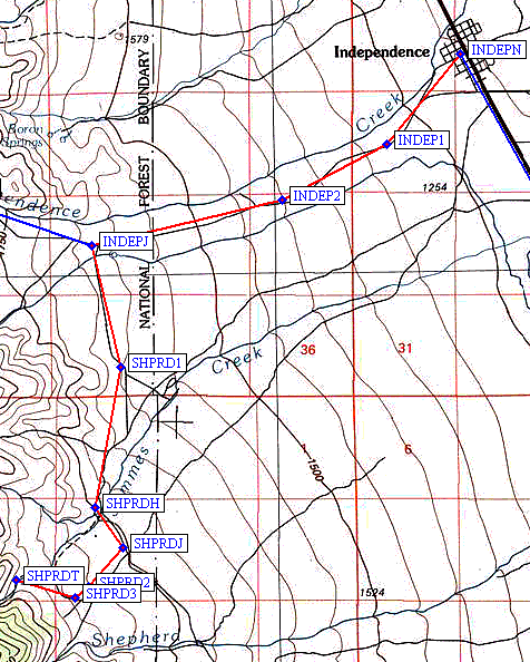
Take the Onion Valley Road (aka Market Street) west from the center of Independence (waypoint INDEPN and the only traffic light in town), but don't go all the way to Onion Valley! Turn south (left) onto unpaved Foothill Road, at the signed turn-off to Shepherd Pass (waypoint INDEPJ) about 4.5 miles from town.
Turn right at the SHPRD1 fork where the road becomes very winding and you should ignore side roads, turn hard left at SHPRDH just BEFORE the sign for Symmes Creek. Waypoint SHPRDH is at the horse trailhead, and you can park your car here if the road ahead gets too rough. This part of the road was apparently graded in 2009, so old instructions to turn AFTER the sign put you on a worse road.
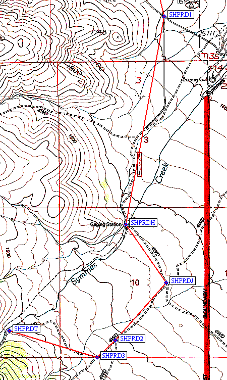
Hikers should continue (3.3 miles from the Onion Valley Road junction) past the stock trailhead, and turn right (southwest) at waypoint SHPRDJ where there is a wooden sign marked (for the first time) 'Shepherd Pass Hiker Trail'. On the way out, this junction has a wooden sign marked 'Onion Valley Road.' Beyond this junction, small cars used to need caution for rocks and high center clearance between ruts, but as of 2009 passenger cars should have no trouble reaching the trailhead. (If you don't make this turn, you'll be headed for Bairs Creek and/or George Creek.)
Take the righ fork at SHPRD2, and turn right again at SHPRD3. Both of these turns are marked by small wooden 'TRAIL' signs. The trailhead is at SHPRDT, including a nice sign about when the area is closed for bighorn sheep and a pit toilet that no one seems to use. Access to the stream is possible, but keep in mind that it's downstream of FIVE stock trail crossings. (Probably not the best place to fill up on water.)
The trail starts in the Symmes Creek drainage, climbs over a saddle and drops 600' into the Shepherd Creek drainage, goes past a year-round stream before reaching Mahogany Flat, then switchbacks up to Anvil Camp before reaching 'alpine terrain.' This is a hot trailhead, and some people do 1500-2000' of climbing (with a dry bivy) after dinner to escape the mid-day heat below Anvil. Shepherd Pass is over-used and the lake has filled with yellow algae in the last few years. Water filters clog with a one-night stay. Camp somewhere else, like the high lakes in Williamson Bowl or along the stream that forms to the west of the pass.
FOOTNOTE FROM KEN: On page 32, Secor says that it's 6 miles to Anvil Camp, but actually it's at least 7.5 miles (Sierra South, Winnett) and 8+ miles based on my hike out in Sep 2009. Total distance to the pass is at least 9.5 miles (not 8), also as per Sierra South.
Useful Links: