San Francisco Area Trailheads
Revised 23 Apr 2012 - please send updates to the webmaster
Coastal California trailheads:
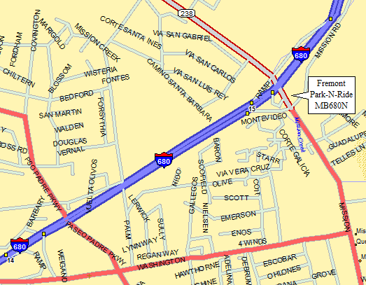
WARNING: This is the NORTHERN of two Mission Blvd exits from 680,
NOT the one people use to climb Mission Peak! (Two demerits for
the highway engineer who decided we should have two nearby exits
from the same freeway to the same surface street.)
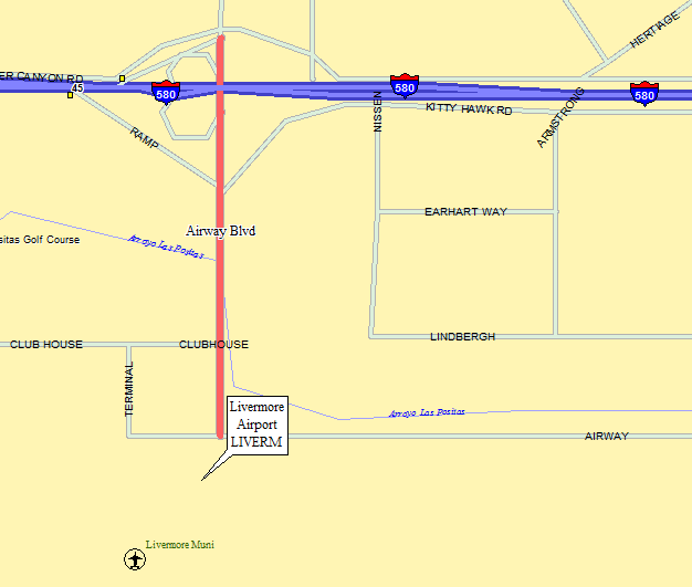
Take 580 east about 6 miles from the 680 intersection, then go south on
Airway Blvd in Livermore. As the road bends left there is an air traffic
control tower and a parking lot on your right (waypoint LIVERM).
The road between the tower and the lot is Terminal Circle:
it's the one right AFTER (south of) Clubhouse.
The map shows Airway (Blvd) turning east at Terminal (Circle),
which is almost what happens. Newer construction made the corner
less sharp, but it's still there.
The traffic control tower is NOT a biggie, since this is a one-gate local
airport, but it has a mailbox just outside and a restroom available inside.
You should ask at the counter inside for a FREE permit so they know when
you will return. The lot is across the street to the north.
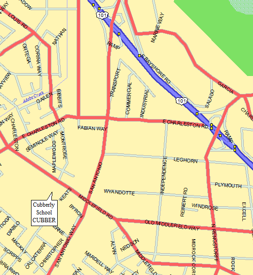
Get on San Antonio Road. From US-101, there is a San Antonio exit.
El Camino Real and Central Expressway also intersect with San Antonio.
Take San Antonio to Middlefield Road, and turn towards Palo Alto.
US-101 drivers turn right onto Middlefield, but El Camino and Central
drivers turn left. Cubberley Community Center is a large complex
about 1/4 mile north of the San Antonio/Middlefield intersection,
on your left. The driveway is opposite Montrose Street, try to
park where you won't be in the way (waypoint CUBBER).
An alternative is to use the same exit, then turn left at the first light.
Go one block, turn left and park on the street across from the Mercedes Benz
dealer.
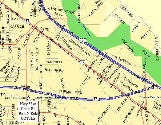
Meet at the park'n'ride at the Cottle Road off ramp of Hwy 85, south of the 101/85
intersection (waypoint COTTLE).
There is a station for the San Jose light rail within walking distance of that intersection.
Useful Links:
Fremont - park'n'ride - GPS Route CARPOOL BAY AREA
Use the park'n'ride at I-680 and Mission Blvd, across from MacDonalds (waypoint MB680N).
Livermore Airport - GPS Route CARPOOL BAY AREA
Milpitas - misc parking lots
The Bank of America lot at 237 and 680. Or better yet,
WalMart at McCarthy Ranch shopping center couple of lights west on 237.
Palo Alto - Cubberley School - GPS Route CARPOOL BAY AREA
Pleasanton - parking lots
Turn right from first exit on 580 east of 680 (Hopyard).
Turn right at first light, then right into restaurant parking lot (Denny's?).
Park in the paved circle in the back.
South San Jose - Cottle Road & Hwy 85 - GPS Route CARPOOL BAY AREA
Singles Carpool Spots - multiple standard locations
The Singles section of the Loma Prieta chapter does carpools very well.
They have a standard set of rendezvous points, so frequently used that
they just refer to them by number. (Like the prisoners who have heard
all the same jokes so many times that they just call them out by number...)