Old Woman Mountain
Revised Jan 2009 - please send updates to the webmaster
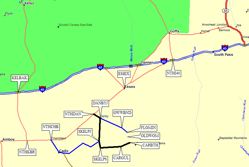
West of Needles, the National Trails Highway (aka Historic Route 66) runs south of I-40 through the towns of Essex, Amboy, etc. The interstate more or less killed these towns, and the turn we're looking for is in between what's no longer there. Danby is more an intersection of dirt roads and railroad tracks than an actual town. It doesn't even have ruins!
From the west, like coastal CA, leave I-40 at Kelbaker Road (waypoint KELBAK) and go south to the National Trails Highway (waypoint NTHKBR). Follow that pavement east and then northeast to the signed Danby turnoff (waypoint NTHDAN). There is a DPS Guide route through Cadiz, shown in blue on the map, but I haven't personally driven it and I'm betting this route has better roads.
From the east, like from the Chemehuevi Valley peaks, leave I-40 at Summit Springs (waypoint NTHJ40) where the National Trails Highway goes southwest from the interstate. Drive through Essex to the signed Danby turnoff (waypoint NTHDAN).
However you get to Danby, leave the National Trails Highway pavement at a small green sign for Danby (waypoint NTHDAN) and go southeast on a wide but washboarded dirt road until you cross the railroad tracks. It's interesting to note that the signs indicate a different number of tracks depending on which side you're on. Just over the tracks there are two dirt roads that appear to parallel the railroad tracks southwest. Waypoint DANBYJ is at the SECOND parallel dirt road, which takes you due south through waypoint SKELPR on the Skeleton Pass Road (which is never signed as that, but appears in mapping databases with that label). If you stay next to the tracks, you're on the wrong road.
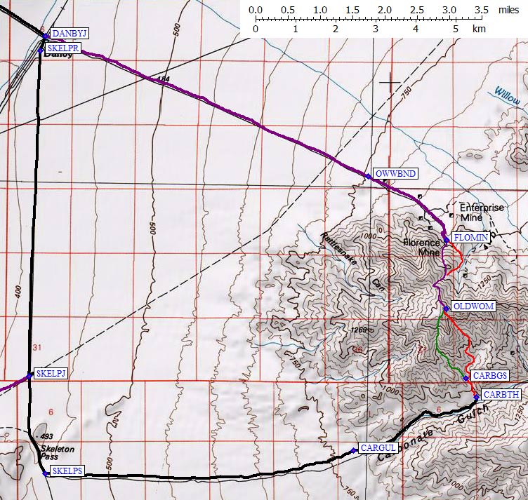
The DPS Guide has a route to the north side of Old Woman, but the road has been closed at a new wilderness boundary which makes that approach a longer walk than the Guide indicates. I haven't done that side of the mountain, and would appreciate details from anyone who has. The driving route should go from DANBYJ southeast to the Old Woman Wilderness boundary (waypoint OWWBND), after which you walk up the road to the Florence Mine (waypoint FLOMIN).
This driving route goes to Skeleton Pass for the southern approach to Old Woman, via Carbonate Gulch. (GPS routes OLD WOMAN WEST and OLD WOMAN EAST, not the other two routes!) Go south from Danby, past the Cadiz route junction (waypoint SKELPJ). Ignore the big road going east from here, ignore the big fenced enclosure, just continue south as the road becomes rougher and climbs more steeply to Skeleton Pass itself (waypoint SKELPS). High clearance would be good, but passenger cars should make it if they have skilled drivers.
There's a vague and unmarked junction at the pass, where the road levels out a bit. Turn east (left) on an even fainter and rougher two-track 4WD road. 4WD is not yet required, but passenger cars should stop here. The road parallels Carbonate Gulch on the north rim. At waypoint CARGUL you will drop into wash. Now it's a very bad road: slow going, some risk of cutting a tire, potential washouts, etc. We didn't need 4WD, but we did need to pay attention and have high clearance.
The trailhead (waypoint CARBTH) is a narrow steep canyon cut into
the north wall of the wash. You can drive only a short distance up the
side canyon before being blocked by boulders. The canyon here is a
flat sandy surface, with apparent shelter from the wind... but when
it's really windy it can whip sand up after all. (We learned that
as we were packing up to go.)
Detailed Map, see also area map above:
Labels here, and on the overall map above, are in the waypoint file.
Useful Links: