Fallen Leaf Lake And Mt Tallac
Revised 19 Jan 2015 - please send updates to the webmaster
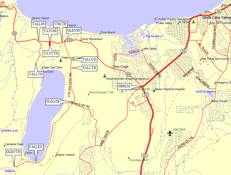
Fallen Leaf Lake is near the southwest corner of Lake Tahoe, between Emerald Bay and South Lake Tahoe. These trailheads are usually used to reach Mt Tallac, Dicks Peak, and Jacks Peak. Permits are technically required year round (even for day use). The visitor center is just over 3 miles northwest of where Hwy 89 and Hwy 50 split (50 goes up the east short of Lake Tahoe, 89 goes up the west shore).
Dayhike permits can be filled out at the trailhead if there are any in the box, overnight requires a visit to an open ranger station. As of 2015 the trailhead sign says nearby year-round permit offices are in Pollock Pines (530-647-5415) and South Lake Tahoe (530-543-2694). There is a Forest Service Visitor Center (530-543-2736, waypoint VISCTR) on the north side of Hwy 89 where you can get wilderness permits, but it's only open in the summer.

Fallen Leaf Road follows the east shore of Fallen Leaf Lake. There are brown 'Fallen Leaf Lake' signs north and south of the intersection with Hwy 89, but no big sign right at the intersection itself (waypoint GLEN89). After you're on Fallen Leaf Rd, there is a sign that says Notice! This road not subject to snow removal. Use at your own risk. I met a local with a key to the gate (at waypoint FLGATE, described below) who says the road IS currently being plowed in winter because a snowplow driver has elderly parents living at the south end of the lake.
Follow the road south past the Fallen Leaf Campground (waypoint FALLCG) which is open May-September. Just beyond the campground is a Fallen Leaf Trail sign (waypoint FALLTH) where several cars were parked in December. This trail goes around the north end of the dam and follows the east shore of the lake, but in winter that snow slope is very steep and the trail isn't very usable. There is unofficial road-side parking in the general campground area, but only the main road is plowed and 4WD or chains would be advisable.
Continuing south, just before a road intersection (marked as elevation 6502 on the USGS topo maps) there is a gate (waypoint FLGATE). This is the end of public access in the winter. Locals have a key but the rest of us will have to wedge our cars off the side of the road here. There is no parking lot as such, but there is room to turn around. Be careful not to block the gate if you park here.
In the summer you can drive all the way to the south end of the lake, through quite a few houses and the city of Fallen Leaf (waypoint FALLEN), eventually arriving at the Glen Alpine trailhead (waypoint GLENTH) which sports some bathrooms but no running water. Not bad for a free trailhead! In the summer or late spring Glen Alpine is a great place to start, with a nice walk to Gilmore or Half Moon lakes on your way to a one-day loop of Jack, Dick, and Tallac.

The official Mt Tallac trailhead is 1 mile south of Hwy 89 at waypoint TALLTH. See the note at the top of this page about wilderness permits!
There are brown 'Mt Tallac' signs north and south of where you leave Hwy 89 (waypoint TALL89), which is 4 miles northwest on Hwy 89 from the junction where it leaves Hwy 50 (waypoint 089050 in South Lake Tahoe). This trailhead is well marked, including the two turns you have to make between the highway and the trailhead. It used to be open in winter and did not appear to require Sno-Park permits, but as of Jan 2015 the road is gated at the highway and it's not clear whether parking by that gate is legal. The road is paved, a lot closer to the mountain, and about 100' elevation higher than the Taylor Creek Sno-Park... but if it is closed you can walk to this trailhead from the Sno-Park (see below).
There is a Sno-Park near Taylor Creek (waypoint TAYCTH), halfway between the Mt Tallac trailhead turnoff and the visitor center. That's 3.5 miles northwest on Hwy 89 from the junction where it leaves Hwy 50 (waypoint 089050 in South Lake Tahoe). The road to the Sno-Park has no signs at all southbound on Hwy 89, but there is one small sign visible when driving north (waypoint TAYC89). It is across from small building and an 'End 35mph' sign, just north of the visitor center (waypoint VISCTR).
This former gravel pit is now a large parking area with several loops, so it might be hard to find people here. Once you are back from the highway, in the parking loop, there is a portable toilet, Sno-Park permit-only signs, but no signs about overnight parking. Sno-Park Permits are probably available many places, but I often buy mine at the Meyers Chevron station (waypoint MEYERS).
There is a gate across the road which goes from the Sno-Park turnoff to homes along the west shore of Fallen Leaf Lake. To reach the trail up Mt Tallac, follow that paved road about 1.2 miles past a large meadow to another small meadow where the road turns sharply left. Here there is a small post and an unmarked use trail (waypoint TAYXRD) which leads you up to the trail (waypoint TAYXTR) just above the Mt Tallac trailhead (waypoint TALLTH).
Useful Links: