Brewer Creek
(Hotlum-Wintun on Mt Shasta)
Revised 24 Jun 2012 - please send updates to the webmaster
The Brewer Creek trailhead gives you access to the Hotlum and Wintun glaciers, and to the straightforward (crevasse-free) Hotlum-Wintun Ridge route. North Gate will also provide access to the Hotlum Glacier via the Hotlum-Bolam Ridge and might be a more direct line to the upper glacier. Please send waypoints or a track log for North Gate! Brewer Creek can easily be used to reach the Hotlum Glacier, and it's more accessible for passenger cars, but I'd like to add the North Gate trailhead.
More Mountain Info:
Two miles south of the village of Mount Shasta, leave I-5 toward McCloud on Hwy 89 (waypoint 5JCT89). Hwy 89 goes over Snowmans Hill Summit (waypoint SKIJCT) 5 miles from the freeway, where there is a signed intersection for the local ski area (Ski Park Hwy). Others have said there is a way to Brewer Creek from the Ski Park, but also said it was very winding and not well maintained (not recommended). 10 miles from the freeway Hwy 89 goes past the McCloud Ranger Station (waypoint MCLOUD) where you can get summit passes ($20 per person) and wilderness permits. Permits are free but separate permits are required for each person. You can also get summit passes at the Fifth Season store in Mt Shasta, and many trailheads around the peak have self-payment envelopes.
Overall Map: (see below for details near trailhead)
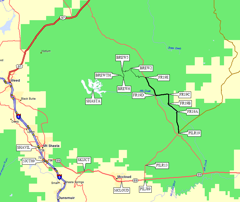
13 miles from the freeway, 3 miles east of McCloud (waypoint MCLOUD), turn left (north) on the well-signed Pilgrim Creek Road (waypoint PILJ89). The road sign says Pilgrim Creek Road, Shasta Wilderness Trailheads, and Snowmobile Park, and immediately after the turn you'll see a sign saying Military Pass Road is 7 miles away.
Follow paved Pilgrim Creek Road due north, and stay on the pavement as it bends northeast less than 2 miles from Hwy 89 (waypoint PILR13). Some maps show Pilgrim Creek Road going north and it looks like this is an intersection with Forest Road 13, but when you're driving it's just a bend in the road, not like an intersection at all. My Garmin GPS labels three different roads with the same name, so don't bet on street-level routing here!
Just over 20 miles from the freeway turn left (north) on Military Pass Road (waypoint PILR19) at a sign that also says Brewer Creek Trailhead and Forest Road 19. I'll call it FR19 since that's the way it's consistently signed from here on. FR19 is the heavy black line on the map above, and may or may not be the same as what used to be called Military Pass Road! You're still on pavement here and none of the side roads are paved so it's easy to stay on the correct road.
Take FR19 north about 2.5 miles (almost 23 miles from I-5) and turn left at a fork with a sign saying 13 miles to Brewer Creek Trailhead (waypoint FR19A). The pavement ends just before this fork. Follow FR19 northwest up Ash Creek 1.5 miles to the base of Sugar Pine Butte. Here (waypoint FR19B) another road comes in from the left which means you take the left fork on the way out, but it's fairly obvious which is the main road. Continue north on FR19, which is a great dirt road, until you see another sign saying Brewer Creek to the left (west) almost 26 miles from the freeway (waypoint FR19C). FR19 apparently turns west here, so look for a small sign after the intersection!
My software shows Military Pass Road on the other side of Sugar Pine Butte, which may explain the contradictory driving directions on other websites. I think the signs for Brewer Creek may have been moved around to route you on the best roads, and if you follow these directions and the road signs you will bypass parts of Military Pass Road.
There's another sign for Brewer Creek in another 1.5 miles (waypoint FR19D) where you turn right (northwest) just over 27 miles from the freeway. The next Brewer Creek sign is where the road changes color from red to gray (waypoint FR19E) about 30 miles from the freeway. I think going straight here takes you to North Gate and Military Pass, but I'm not sure! Turn left (west) off FR19 onto a road signed as 42N02 (waypoint FR19E) to reach the Brewer Creek trailhead. This road is not as good as FR19, with some erosion ditches, washboards, and more rocks.
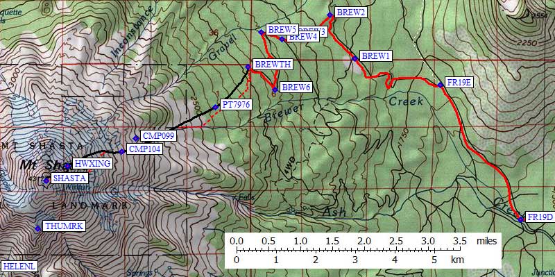
2.7 miles from FR19 (32.6 miles from the freeway) there is a Brewer Creek sign, near Point 6465, BEFORE an intersection is even in view. Turn left onto 42N10 when you get there (waypoint BREW2), basically doing a u-turn from northbound to southbound. The road soon turns southwest as it deteriorates, but it remains passable for any passenger car. There are several signs about permits and trailheads, long before you get to the actual trailhead! Keep driving. Turn left (south) 33.4 miles from the freeway (waypoint BREW3), then turn right a third of a mile later when you intersect what might be an older route to the trailhead (waypoint BREW4).
34 miles from I-5 is a sharp left turn (to the south) with a large flat area which could serve as an early spring trailhead (waypoint BREW4). Above here the terrain is steeper and the road has more snow drifts that last into early summer.
The official Brewer Creek Trailhead (waypoint BREWTH) is at 7300', almost 36 miles from the freeway, not quite at the end of the road switchbacks shown on the USGS topo map. There is an obvious trail from the trailhead information sign going up the road shown on the topo, but it soon vanishes in forest duff or volcanic dirt or snow. If not for minimizing damage to the terrain it would not be worth following, and we did not manage to follow it for more than half a mile mid-June in 2012. Take a GPS, and know how to use it, because it's easy to walk cross-country past your car on the way down.
Here, as at all self-service Mt Shasta trailheads, each person needs to fill out their own wilderness permit, pick up human waste pack-out bags, and buy a summit pass. Waste bags and summit passes are also available at ranger stations and the Fifth Season (waypoint 5THSEA, a wonderful climbing store in the village of Mt Shasta). You can drop your full waste bags at the trailhead outhouse on the way down.
Trailhead Details Map: (see below for overall route)
Useful Links: